Area is the quantity that expresses the extent of a two-dimensional figure or shape, or planar lamina, in the plane. Surface area is its analog on the two-dimensional surface of a three-dimensional object. Area can be understood as the amount of material with a given thickness that would be necessary to fashion a model of the shape, or the amount of paint necessary to cover the surface with a single coat. It is the two-dimensional analog of the length of a curve or the volume of a solid.

The United States Air Force facility commonly known as Area 51 is a highly classified remote detachment of Edwards Air Force Base, within the Nevada Test and Training Range. According to the Central Intelligence Agency (CIA), the correct names for the facility are Homey Airport and Groom Lake, though the name Area 51 was used in a CIA document from the Vietnam War. The facility has also been referred to as Dreamland and Paradise Ranch, among other nicknames. USAF public relations has referred to the facility as "an operating location near Groom Dry Lake". The special use airspace around the field is referred to as Restricted Area 4808 North (R-4808N).
A ZIP Code is a postal code used by the United States Postal Service (USPS) in a system it introduced in 1963. The term ZIP is an acronym for Zone Improvement Plan; it was chosen to suggest that the mail travels more efficiently and quickly when senders use the code in the postal address. The basic format consists of five digits. An extended ZIP+4 code was introduced in 1983 which includes the five digits of the ZIP Code, followed by a hyphen and four additional digits that reference a more specific location.

A metropolitan area, sometimes referred to as a metro area or commuter belt, is a region consisting of a densely populated urban core and its less-populated surrounding territories, sharing industry, infrastructure, and housing. A metro area usually comprises multiple jurisdictions and municipalities: neighborhoods, townships, boroughs, cities, towns, exurbs, suburbs, counties, districts, states, and even nations like the eurodistricts. As social, economic and political institutions have changed, metropolitan areas have become key economic and political regions. Metropolitan areas include one or more urban areas, as well as satellite cities, towns and intervening rural areas that are socioeconomically tied to the urban core, typically measured by commuting patterns. In the United States, the concept of the metropolitan statistical area has gained prominence.

Population density is a measurement of population per unit area or unit volume; it is a quantity of type number density. It is frequently applied to living organisms, and most of the time to humans. It is a key geographical term. In simple terms population density refers to the number of people living in an area per kilometer square.

In law, an unincorporated area is a region of land that is not governed by a local municipal corporation; similarly an unincorporated community is a settlement that is not governed by its own local municipal corporation, but rather is administered as part of larger administrative divisions, such as a township, parish, borough, county, city, canton, state, province or country. Occasionally, municipalities dissolve or disincorporate, which may happen if they become fiscally insolvent, and services become the responsibility of a higher administration. Widespread unincorporated communities and areas are a distinguishing feature of the United States and Canada. In most other countries of the world, there are either no unincorporated areas at all, or these are very rare; typically remote, outlying, sparsely populated or uninhabited areas.

Petroglyphs are images created by removing part of a rock surface by incising, picking, carving, or abrading, as a form of rock art. Outside North America, scholars often use terms such as "carving", "engraving", or other descriptions of the technique to refer to such images. Petroglyphs are found worldwide, and are often associated with prehistoric peoples. The word comes from the Greek prefix petro-, from πέτρα petra meaning "stone", and γλύφω glýphō meaning "to carve", and was originally coined in French as pétroglyphe.

The Chicago metropolitan area, or Chicagoland, is the metropolitan area that includes the city of Chicago, Illinois, and its suburbs. With an estimated CSA population of 9.9 million people and an MSA population of 9.5 million people, it is the third largest metropolitan area in the United States.
A telephone numbering plan is a type of numbering scheme used in telecommunication to assign telephone numbers to subscriber telephones or other telephony endpoints. Telephone numbers are the addresses of participants in a telephone network, reachable by a system of destination code routing. Telephone numbering plans are defined in each of administrative regions of the public switched telephone network (PSTN) and they are also present in private telephone networks. For public number systems, geographic location plays a role in the sequence of numbers assigned to each telephone subscriber.

Telephone numbers in the United Kingdom are administered by the UK government's Office of Communications (Ofcom). For this purpose Ofcom established a telephone numbering plan, known as the National Telephone Numbering Plan, which is the system for assigning telephone numbers to subscriber stations.

An urban area or urban agglomeration is a human settlement with high population density and infrastructure of built environment. Urban areas are created through urbanization and are categorized by urban morphology as cities, towns, conurbations or suburbs. In urbanism, the term contrasts to rural areas such as villages and hamlets and in urban sociology or urban anthropology it contrasts with natural environment. The creation of early predecessors of urban areas during the urban revolution led to the creation of human civilization with modern urban planning, which along with other human activities such as exploitation of natural resources leads to human impact on the environment.
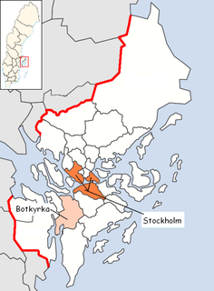
Norra Botkyrka usually refers to the northern residential areas of Botkyrka Municipality near Stockholm in Sweden.

The Schengen Area is an area comprising 26 European states that have officially abolished passport and all other types of border control at their mutual borders. The area mostly functions as a single jurisdiction for international travel purposes, with a common visa policy. The area is named after the 1985 Schengen Agreement.

The San Francisco Bay Area is a populous region surrounding the San Francisco, San Pablo and Suisun estuaries in the northern part of the U.S. state of California. Although the exact boundaries of the region vary depending on the source, the Bay Area is generally accepted to include the nine counties that border the aforementioned estuaries: Alameda, Contra Costa, Marin, Napa, San Mateo, Santa Clara, Solano, Sonoma, and San Francisco. Other sources may exclude parts of or even entire counties, or expand the definition to include neighboring counties that don't border the bay such as San Benito, San Joaquin, and Santa Cruz.