Norsborg

Last updated
Norsborg
Residential district
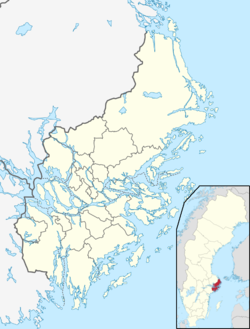
Location map Sweden Stockholm County.png
Red pog.svg
Norsborg
Location in Stockholm County
Coordinates: 59°15′06″N17°48′35″E / 59.25167°N 17.80972°E / 59.25167; 17.80972
CountryFlag of Sweden.svg  Sweden
County Stockholm County
Municipality Botkyrka Municipality
Time zone UTC+1 (CET)
  Summer (DST) UTC+2 (CEST)

Norsborg is a part of Botkyrka Municipality in Stockholm County, Sweden. Norsborg consists of the residential areas Hallunda, Eriksberg and Slagsta. Norsborg and Hallunda are contiguous suburbs.

Contents

History

Norsborg was previously a country estate in the Botkyrka parish, situated on a bay of Vårbyfjärden and with some of the property facing Bornsjön, as well as Kärsby and Tomtberga with an area of 350 hectares.

The area, which was originally called Borg and was part of the village of Hundhamra, but in the late 1700s the property was named Norsborg after the owner Count Johan Liljencrantz's wife Eleonora Stjernstedt. [1] Liljencrantz also owned Sturehov, Slagsta farm and Fittja in the same parish and had Norsborg's manor built. From his time a significant part of the garden and the large English-style park originate with a gazebo by Olof Tempelman and a view tower that long adorned Norsborg. [1]

Norsborg was purchased in 1900 for SEK 185,000 by the City of Stockholm for its water pipeline from Bornsjön. The city built their main station of the management, Norsborg waterworks, with filtration basins, pumping stations, electricity plants, residential buildings and more, and in 1912 the city council decided to place the entire water main plant there. The waterworks has a yearly capacity of 80,000,000 m³ of drinking water and is the largest fresh water plant serving Stockholm.

Modern development

The area consists largely of high-rise areas built under the Million Programme and several are located near the E4 / E20 motorway, but the development also includes a large area with townhouses and semi-detached houses, which are characterized by well-preserved nature areas. There are also several churches in the area.

The population is about 17,000 people, of which 81.2 per cent with foreign background in 2017. [2] According to police, Norsborg is a problem area from a crime point of view, which is classified as a particularly vulnerable area. [3]

Norsborg has the south-western terminus of the Stockholm metro system's red line. It was opened in 1975 and is the westernmost of all Stockholm metro stations.

View from Eriksberg over Norsborg, September 2014. Hallunda fran Eriksberg 2014.jpg
View from Eriksberg over Norsborg, September 2014.

Related Research Articles

<span class="mw-page-title-main">Botkyrka Municipality</span> Municipality in Stockholm County, Sweden

Botkyrka Municipality is a municipality in Stockholm County in east central Sweden, not far from the capital Stockholm. Its seat is located in the town of Tumba.

<span class="mw-page-title-main">Ekerö Municipality</span> Municipality in Stockholm County, Sweden

Ekerö Municipality is a municipality in the province of Uppland in Stockholm County in east central Sweden. The name derives from the name of the main island within the municipality whose name is Ekerön, and literally means "Oak Island". Its seat is located in the town of Ekerö.

<span class="mw-page-title-main">Sundbyberg Municipality</span> Municipality in Stockholm County, Sweden

Sundbyberg Municipality is a municipality in Stockholm County in east central Sweden, just north of the capital Stockholm. Sundbyberg is wholly within the Stockholm urban area and has a 100% urban population.

<span class="mw-page-title-main">Salem Municipality</span> Municipality in Stockholm County, Sweden

Salem Municipality is a municipality in Stockholm County in east central Sweden. The name traces its origins from Slæm in the 13th century, but was changed to Salem in the 17th century, inspired by the Biblical name of Jerusalem. Its seat is located in Salem.

<span class="mw-page-title-main">Märsta</span> Place in Uppland, Sweden

Märsta is a suburb of Metropolitan Stockholm, a locality and the seat of Sigtuna Municipality, Stockholm County, Sweden with 27,034 inhabitants in 2015. The town is situated close to Stockholm's main international airport, Arlanda. Even though its origins go back to around 500 AD, Märsta is a widespread modern residential area. Märsta has a mix of multi-storey dwellings and smaller houses. It is in a phase of expansion and new residential areas are built both in central parts of Märsta and in the surrounding areas like for instance Steningehöjden. Märsta can be reached by Stockholm commuter rail trains running at quarterly intervals during daytime and by bus from Stockholm Arlanda Airport. The central parts of Märsta has a shopping area "Märsta Centrum" with various shops, pub and restaurants. Another smaller shopping area is "Valsta Centrum". East of the central parts of Märsta there is an industrial area and a bit further east close to the airport a shopping mall "Eurostop". Most parts of Märsta and the municipality of Sigtuna can be reached with local bus services originating at the Märsta Railway Station and also connecting with commuter trains.

<span class="mw-page-title-main">Million Programme</span> Swedish housing programme

The Million Programme was an ambitious public housing program implemented in Sweden between 1965 and 1974 by the governing Swedish Social Democratic Party to ensure the availability of affordable, high quality housing to all Swedish citizens. The program sought to construct one million new housing dwellings over a ten-year period, which it accomplished. As part of its intention to modernize Swedish housing, it also demolished many older buildings that national and local governments considered obsolescent, unhealthy or derelict.

<span class="mw-page-title-main">Kungsholmen</span> Island in the Lake Mälaren in Stockholm, Sweden

Kungsholmen is an island in Lake Mälaren in Sweden, part of central Stockholm, Sweden. It is situated north of Riddarfjärden and considered part of the historical province Uppland. Its area is 3.9 km2 (1.5 sq mi) with a perimeter of 8.9 km (5.5 mi). The highest point is at Stadshagsplan at 47 metres (154 ft). The total population is 71,542.

Norra Botkyrka usually refers to the northern residential areas of Botkyrka Municipality near Stockholm in Sweden.

<span class="mw-page-title-main">Alby, Botkyrka</span>

Alby is a suburb in Botkyrka Municipality within Stockholm.

<span class="mw-page-title-main">Saint Botvid</span>

Saint Botvid was a Christian missionary in Sweden during the 11th and early 12th centuries.

<span class="mw-page-title-main">Hallunda</span> Human settlement in Sweden

Hallunda is a part of Botkyrka Municipality, Stockholm County, Sweden. Hallunda and Norsborg are continuous suburbs. Around 79% of the population of Hallunda are of Non-Swedish descent.

Vårbyfjärden is a strait in south-eastern Lake Mälaren south-west of Stockholm in Sweden.

<span class="mw-page-title-main">Empresas Públicas de Medellín</span>

Empresas Públicas de Medellín (EPM) was established on 18 November 1955 as a residential public utilities company which, initially, only served the inhabitants of Medellin, Colombia its hometown.

<span class="mw-page-title-main">Norsborg metro station</span> Stockholm Metro station

Norsborg metro station is the end station on the red line of the Stockholm metro, located in Norsborg, Botkyrka Municipality. The distance to Slussen is 20.8 km. The station was opened on 12 January 1975 as the southwestern terminus of the extension from Fittja.

<span class="mw-page-title-main">Hallunda metro station</span> Stockholm Metro station

Hallunda metro station is a station on the red line of the Stockholm metro, located in Hallunda, Botkyrka Municipality. The station was opened on 12 January 1975 as part of the extension from Fittja to Norsborg. The distance to Slussen is 20.1 km (12.5 mi).

<span class="mw-page-title-main">Alby metro station</span> Stockholm Metro station

Alby metro station is a station characterized by the colorful art work inspired by the local petroglyphs. The station is located in Alby, Botkyrka Municipality, on the red line of the Stockholm metro. The station was opened on 12 January 1975 as part of the extension from Fittja to Norsborg. It is 19 km away from Slussen.

<span class="mw-page-title-main">Fittja metro station</span> Stockholm Metro station

Fittja metro station is a station on the red line of the Stockholm metro, located in Fittja, Botkyrka Municipality, Sweden. The outdoor station was opened on 1 October 1972 as the south-western terminus of the extension from Vårberg. On 12 January 1975 the line was extended further to Norsborg.

<span class="mw-page-title-main">Slagsta</span> Residential district in Stockholm County, Sweden

Slagsta is a municipal district and a residential area of Botkyrka Municipality, Stockholm County, southeastern Sweden. It is located between the E4 south and part of Lake Mälaren in the north. The area is named after Slagsta farm.

<span class="mw-page-title-main">Fittja gård</span>

Fittja gård is a former manor, coaching inn and station for post riders in Fittja, Botkyrka Municipality, Stockholm County, east-central Sweden. Fittja Värdshus, attached to it, was one of the largest travellers' hostels in Sweden during the 17th and 18th centuries. From 1660 to 1916 the Tingsrätt for the Svartlösa Hundred was located on the estate, and the present Fittja gård dates to 1812. According to the Stockholm County Museum, the buildings are well-preserved and valued as a cultural heritage. Fittja gård is the headquarters of a mångkulturellt centrum founded in 1987.

<span class="mw-page-title-main">Red line (Stockholm metro)</span> Metro line in Stockholm, Sweden

The Red line, is one of the three Stockholm metro lines. It has a total of 36 stations, of which four are cut and cover, 16 are tunneled, and 15 are on the surface. The line is a total of 41.238 kilometres (25.624 mi) long. It consists of four branches with terminals in Fruängen and Norsborg in the southwest and Mörby center and Ropsten in the northeast.

References

  1. 1 2 "Cultural History of Norsborg" . Retrieved 2020-01-01.
  2. "Områdesfakta Botkyrka kommun" [Census data of Botkyrka municipality]. Retrieved 2020-01-01.
  3. "Utsatta omraden - sociala risker kollektiv formaga o oonskade handelser" [Vulnerable areas - social risks collectively shape undesirable behaviour](PDF). Archived from the original (PDF) on 2016-08-19. Retrieved 2020-01-01.