
Rønde is a town on the southern part of the peninsula, Djursland in Denmark, Northern Europe, 23 kilometers north-east of the north end of Denmark's second largest city, Aarhus. It is in part a commuter town to Aarhus, with a motorway entering Aarhus from the north. Rønde is located between Aarhus, and Aarhus Airport with a 12 kilometer drive from Rønde to the airport.
Mols is a small Danish gathering of hilly peninsulas in the southern part of the larger peninsula of Djursland on the east coast of Jutland. The largest peninsulas of Mols comprise Skødshoved to the west, and Helgenæs to the east.

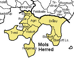
Until 1 January 2007, Ebeltoft municipality was a municipality in Aarhus County on the east coast of the Jutland peninsula in central Denmark. The region lies in a geographic region known as southern Djursland, and more specifically Mols. The municipality covered an area of 276 km2, and had a total population of 14.997 (2003). Its last mayor was Jørgen Brøgger. The main town and the site of its municipal council was the town of Ebeltoft.

Syddjurs Municipality is a municipality in Region Midtjylland in Denmark just north of Aarhus and is a part of the Aarhus area. It covers an area of 696.7 km² and has a population of 44,076.

Djursland is a 1,417 km2 hilly lowland peninsula in Denmark at the entrance to the Baltic Sea, between Denmark and Sweden in Northern Europe. Djursland protrudes into the Kattegat sea, as part of the larger peninsula of Jutland, which itself extends from the Central European continent. Djursland comprises the two municipalities of Norddjurs and Syddjurs.

Helgenæs is a peninsula, approximately twenty square kilometres in size, stretching out from Mols in Denmark. Mols is itself part of the large peninsula of Djursland, in the middle of the Kattegat sea between Denmark and Sweden.

Grenaa is a Danish town and seaport on the east coast of the Jutlandic peninsula. Tourism, education and commerce are important sectors in the economy of Grenaa. It is the only larger town on Djursland. Grenaa is the municipal seat, and the largest town, in Norddjurs Municipality, which covers the northern half of Djursland.

Sjællands Odde is a 15-kilometre-long (9.3 mi) peninsula on the northwest coast of Zealand between the Kattegat and Sejerø Bay. From the outermost point of the peninsula, Gniben, a reef juts some 10 kilometres (6.2 mi) out into the Kattegat.

Mols Bjerge National Park or Nationalpark Mols Bjerge is a Danish national park in the area known as Mols Bjerge in Syddjurs Municipality, Central Jutland, inaugurated on 29 August 2009. The protected area, measures 180 square kilometres (69 sq mi) in size. The Mols Hills, reaching a height of 137 metres (449 ft), are centrally located in the park, and take up 2,500 ha. "More than half of all wild Danish plant species" can be found at Mols Bjerge.

Glatved Beach is a coastline 10 km south of the town Grenaa in Denmark. The 5 km long beach is part of a stony coastline with fairly deep water close to the shore, spanning the 50 km long eastern shore of the peninsula, Djursland, and situated by the Kattegat sea. This stony coast starts at The Cliffs of Gjerrild to the north on Djursland, and ends 50 km to the south on Mols at the southern tip of the peninsula.
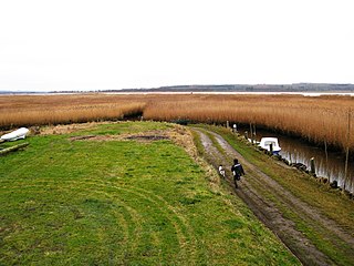
Randers Fjord is a 30 km (19 mi) long Danish fjord in Northern Europe leading to the sea of Kattegat, between Denmark and Sweden. The fjord is the outlet from Denmark's longest river, Gudenå. The upper 13 km (8.1 mi), starting at the town Randers, looks more like a broad river than a fjord. The lower 17 km (11 mi) have extensive reed plains bordering the shores To some extent this inhibits the recreational use of and access to the fjord. In some places, the reed beds are harvested for traditional roof thatching. The shallow eastern part of the fjord is known as Grund Fjord, being an extension of Alling Å.

Trehøje is a Danish vista point with a view of the sea to the east, south and west, located in the Mols Bjerge National Park on the peninsula Djursland between Denmark and Sweden. Three large bronze-age barrows close to each other 127 meters above the sea, have given their name to the place, which contains a group of 22 barrows. "Trehøje" meaning three mounds, is one of four major vista points in the hills of Mols, each with a barrow on top. The others are Ellemandsbjerg, Stabelhøje and Agri Baunehøj.

Jernhatten is a protected hill and view point on the peninsula, Djursland, in Denmark protruding into the sea, Kattegat between Denmark and Sweden. From the top of the hill, 49 meters above sea level, there is a view up and down the coast including and the island Hjelm as well as an inland view over the hilly southern Djursland area, called Mols.

Fornæs Lighthouse in Denmark is located on the eastern tip of the Danish peninsula, Djursland by the sea, Kattegat between Denmark and Sweden, 6 kilometers north of the town Grenaa.

Stabelhøje or Stabel Høje are two Bronze Age Mounds 135 meters and 133 meters above sea level by the village Agri in Mols Bjerge on the peninsula Djursland in Denmark at the entrance to The Baltic Sea in Northern Europe. The burial mounds date back to the early Bronze Ages 1800–1000 years B.C. These hills are some of the more known view points in Mols Bjerge National Park. Other view points in the area are Agri Baunehøj, Trehøje, Ellemandsbjerg and Jernhatten.

Karlsladen is a barn built in 1727 in the Syddjurs Municipality of Denmark that was made into a visitors centre for Mols Bjerge National Park in 2013. The thatched and timbered building covers 1,000 square meters. Access to the visitors centre is free, and it is open 7 days a week all year. Before restoration, the barn was a dilapidated farm building as part of the now publicly owned Kalø Estate.

Ryomgård is a Danish country town with a population of 2,729 located 29 kilometers north east of to the country’s second largest city Aarhus. As such Ryomgård is in part a pendler town to Aarhus.

Agri Bavnehøj is a Danish hill and vista point with a bronze age burial mound, located 137 meters above sea level. It is close to the village of Agri, in Mols Bjerge National Park on the southern part of the Djursland peninsula, 40 kilometres (25 mi) northeast of Denmark’s second largest city, Aarhus. The mound was built 1800 – 1000 years BC. Agri Bavnehøj is the least known of four vista points and burial mounds on southern Djursland, despite being the highest. The others are Stabelhøje, Trehøje and Ellemandsbjerg.

The coastline of Djursland in Denmark is 260 kilometers long as measured from the ferry berth in Voer in the middle of Randers Fjord ending at Avlsgård in Aarhus Bay to the south. There are 18 sandy beaches for swimming along the coastline according to the folder, Kystkort Djursland published by the peninsula's two municipalities, Norddjurs and Syddjurs. These beaches cover 15 – 20%. of the total coastline. The remaining 200 plus kilometres are mostly unspoiled coastal nature.

Isgård is a Danish manor house and farm close to the sea on the hilly southern part of the peninsula Djursland in the Kattegat Sea between Denmark and Sweden at the entrance to the Baltic Sea in Northern Europe. Isgård is located on the Tved peninsula flanking the east coast of Århus Bugt to the west and Begtrup Vig to the east. Isgård lies 10 kilometers from the city Århus in a straight line across Århus Bugt, but 47 kilometers by road around the bay.


