
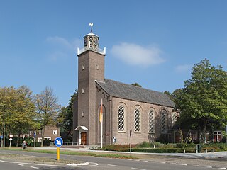
Oostburg is a town in the south-western Netherlands. It is the largest town in the municipality of Sluis, in the province of Zeeland. As of 1 January 2015, its population is 4731, down from 5008 in January 2005. It received city rights in 1237. Before 1 January 2003, Oostburg was also the name of a municipality. It merged with Sluis-Aardenburg to form the new municipality of Sluis. The municipality covered an area of 224.93 km², of which 1.05 km² was water. As well as the town of Oostburg, the former municipality also included the following towns, villages and townships:

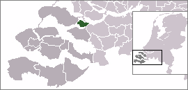
Sluis is a town and municipality located in the west of Zeelandic Flanders, in the south-western Dutch province of Zeeland.

Zeelandic Flanders is the southernmost region of the province of Zeeland in the south-western Netherlands. It lies south of the Western Scheldt that separates the region from the remainder of Zeeland and the Netherlands to the north. Zeelandic Flanders is bordered to the south and to the east by Belgium.

Breskens is a harbour town on the Westerschelde in the municipality of Sluis in the province of Zeeland, in the south-western Netherlands. Its population is 4,787.

Aardenburg is a small city close to the Dutch border with Belgium. It is part of the Sluis Municipality, located in the province of Zeeland in the Netherlands. Its medieval name was Rodenburgh.

Sint Anna ter Muiden is a Dutch town in the province of Zeeland. It is administratively a part of municipality of Sluis, and the town of Sluis lies about 1 km east. It is located on the westernmost point of the Netherlands. It has a population of 50.

IJzendijke is a city in the municipality of Sluis, about 10 km east of Oostburg, in the Dutch province of Zeeland. Its population in 2001 was 1,780.

Cadzand is a town in the Dutch province of Zeeland. It is located in the municipality of Sluis, about 8 km northwest of Oostburg. The village contains 790 inhabitants (2010). Better known to many visitors is the nearby beach at Cadzand-Bad.
Eede is a village in the Dutch province of Zeeland. It is located close on the Belgian border about 3 km south of Aardenburg, in the municipality of Sluis.

Groede is a village in the Dutch province of Zeeland. It is located about 5 km north of Oostburg in the municipality of Sluis.

Heille is a hamlet in the Dutch province of Zeeland. It is located on the Belgium border, about 2 km west of Aardenburg in the municipality of Sluis.

Hoofdplaat is a village in the Dutch province of Zeeland. It is located on the Westerschelde, about 7 km east of Breskens, in the municipality of Sluis.
Nieuwvliet is a village in the Dutch province of Zeeland. It is located about 5 km north of Oostburg, in the municipality of Sluis

Retranchement is a village in the Dutch province of Zeeland. It is located on the Belgian border, about 9 km northwest of Oostburg, in the municipality of Sluis.
Schoondijke is a village in the Dutch province of Zeeland. It is located in the municipality of Sluis, about 5 km south of Breskens.
Sint Kruis is a village in the Dutch province of Zeeland. It is located about 4 km east of Aardenburg, in the municipality of Sluis.

Sint Laurens is a village in the Dutch province of Zeeland. It is located in the municipality of Middelburg, about 3 km north of the city.

Zuidzande is a village in the Dutch province of Zeeland. It is located in the municipality of Sluis.
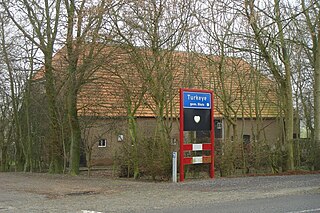
Turkeye is a village of Sluis, a municipality located in the west of Zeelandic Flanders, in the south-western part of the Netherlands. Even though the village is regular village in the province of Zeeland, the name Turkeye is probably an old spelling for Modern Dutch Turkije (Turkey. The name supposedly derives from relations between the Ottoman Turks and the Netherlands. However, depending on the age of the name, there could be a strange anachronism, since the Ottomans never referred to their Empire as Türkiye. Its coordinates are 51°19′N3°35′E. The name of the road to this village is Turkijeweg which means Turkey Road in Dutch.
Sint Philipsland is a former island in the Dutch province of Zeeland. Nowadays it is part of the municipality of Tholen.
