The Great Library of Alexandria in Alexandria, Egypt, was one of the largest and most significant libraries of the ancient world. The library was part of a larger research institution called the Mouseion, which was dedicated to the Muses, the nine goddesses of the arts. The idea of a universal library in Alexandria may have been proposed by Demetrius of Phalerum, an exiled Athenian statesman living in Alexandria, to Ptolemy I Soter, who may have established plans for the Library, but the Library itself was probably not built until the reign of his son Ptolemy II Philadelphus. The Library quickly acquired many papyrus scrolls, owing largely to the Ptolemaic kings' aggressive and well-funded policies for procuring texts. It is unknown precisely how many scrolls were housed at any given time, but estimates range from 40,000 to 400,000 at its height.

Claudius Ptolemy was an Alexandrian mathematician, astronomer, astrologer, geographer, and music theorist who wrote about a dozen scientific treatises, three of which were important to later Byzantine, Islamic, and Western European science. The first was his astronomical treatise now known as the Almagest, originally entitled Mathematical Treatise. The second is the Geography, which is a thorough discussion on maps and the geographic knowledge of the Greco-Roman world. The third is the astrological treatise in which he attempted to adapt horoscopic astrology to the Aristotelian natural philosophy of his day. This is sometimes known as the Apotelesmatika but more commonly known as the Tetrábiblos, from the Koine Greek meaning "Four Books", or by its Latin equivalent Quadripartite.

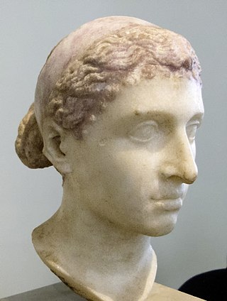
Cleopatra VII Thea Philopator was Queen of the Ptolemaic Kingdom of Egypt from 51 to 30 BC, and its last active ruler. A member of the Ptolemaic dynasty, she was a descendant of its founder Ptolemy I Soter, a Macedonian Greek general and companion of Alexander the Great. After the death of Cleopatra, Egypt became a province of the Roman Empire, marking the end of the last Hellenistic-period state in the Mediterranean and of the age that had lasted since the reign of Alexander. Her first language was Koine Greek, and she was the only known Ptolemaic ruler to learn the Egyptian language.

In Gallo-Roman religion, Rosmerta was a goddess of fertility and abundance, her attributes being those of plenty such as the cornucopia. Rosmerta is attested by statues and by inscriptions. In Gaul she was often depicted with the Roman god Mercury as her consort, but is sometimes found independently.

Cleopatra V was a Ptolemaic Queen of Egypt. She is the only surely attested wife of Ptolemy XII. Her only known child is Berenice IV, but she was also probably the mother of Cleopatra VII. It is unclear if she died around the time of Cleopatra VII's birth in 69 BC, or if it was her or a daughter named Cleopatra VI who co-ruled Ptolemaic Egypt with Berenice IV in 58–57 BC during the political exile of Ptolemy XII to Rome. No written records about Cleopatra V exist after 57 BC and two years later Berenice IV was overthrown by Ptolemy XII, his throne restored with Roman military aid.

Coele-Syria, alternatively Coelo-Syria or Coelosyria, was a region of Syria in classical antiquity. The term originally referred to the "hollow" Beqaa Valley between the Lebanon and the Anti-Lebanon mountain ranges, but sometimes it was applied to a broader area of the region of Syria. The area is now part of the modern-day Syria and Lebanon.

The Epidii were a people of ancient Britain, known from a mention of them by the geographer Ptolemy c. 150. Epidion has been identified as the island of Islay in modern Argyll. Ptolemy does not list a town for the Epidii, but the Ravenna Cosmography mentions Rauatonium, which is assumed to be Southend.
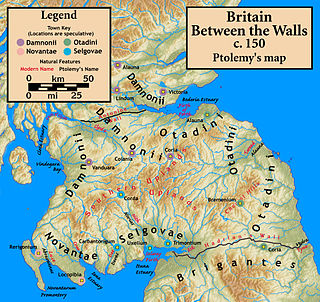
The Novantae were a people of the late 2nd century who lived in what is now Galloway and Carrick, in southwesternmost Scotland. They are mentioned briefly in Ptolemy's Geography, and there is no other historical record of them. Excavations at Rispain Camp, near Whithorn, show that it was a large fortified farmstead occupied between 100 BC and 200 AD, indicating that the people living in the area at that time were engaged in agriculture.

The Geography, also known by its Latin names as the Geographia and the Cosmographia, is a gazetteer, an atlas, and a treatise on cartography, compiling the geographical knowledge of the 2nd-century Roman Empire. Originally written by Claudius Ptolemy in Greek at Alexandria around AD 150, the work was a revision of a now-lost atlas by Marinus of Tyre using additional Roman and Persian gazetteers and new principles. Its translation into Arabic in the 9th century was highly influential on the geographical knowledge and cartographic traditions of the Islamic world. Alongside the works of Islamic scholars – and the commentary containing revised and more accurate data by Alfraganus – Ptolemy's work was subsequently highly influential on Medieval and Renaissance Europe.

The Damnonii were a Brittonic people of the late 2nd century who lived in what became the Kingdom of Strathclyde by the Early Middle Ages, and is now southern Scotland. They are mentioned briefly in Ptolemy's Geography, where he uses both of the terms "Damnonii" and "Damnii" to describe them, and there is no other historical record of them, except arguably by Gildas three centuries later. Their cultural and linguistic affinity is presumed to be Brythonic. However, there is no unbroken historical record, and a partly Pictish origin is not precluded.

The Venicones were a people of ancient Britain, known only from a single mention of them by the geographer Ptolemy c. 150 AD. He recorded that their town was 'Orrea'. This has been identified as the Roman fort of Horrea Classis, located by Rivet and Smith as Monifieth, six miles east of Dundee. Therefore, they are presumed to have lived between the Tay and the Mounth, south of Aberdeen. Andrew Breeze has suggested that the tribal name probably means "hunting hounds". A slightly differing etymology, "kindred hounds", identifies the name with Maen Gwyngwn, a region mentioned in the Gododdin.

The Taexali or Taezali were people on the eastern coast of Britannia Barbara in ancient Scotland, known only from a single mention of them by the geographer Ptolemy c. 150. From his general description and the approximate location of their town or principal place that he called 'Devana', their territory was along the northeastern coast of Scotland and is known to have included Buchan Ness, as Ptolemy refers to the promontory as 'Taexalon Promontory'.

The Lugi were a people of ancient Britain, known only from a single mention of them by the geographer Ptolemy c. 150. from his general description and the approximate locations of their neighbors their territory was along the western coast of the Moray Firth. Ptolemy does not provide them with a town or principal place.

The Cornovii were a people of ancient Britain, known only from a single mention of them by the geographer Ptolemy c. 150. From his description, their territory is reliably known to have been at the northern tip of Scotland, in Caithness. Ptolemy does not provide them with a town or principal place.

Manaw Gododdin was the narrow coastal region on the south side of the Firth of Forth, part of the Brythonic-speaking Kingdom of Gododdin in the post-Roman Era. It is notable as the homeland of Cunedda prior to his conquest of North Wales, and as the homeland of the heroic warriors in the literary epic Y Gododdin. Pressed by the Picts expanding southward and the Northumbrians expanding northward, it was permanently destroyed in the 7th century and its territory absorbed into the then-ascendant Kingdom of Northumbria.

The Carnonacae were a people of ancient Britain, known only from a single mention of them by the geographer Ptolemy c. 150. From his general description and the approximate locations of their neighbors, their territory was along the western coast of modern Ross-shire. Ptolemy does not provide them with a town or principal place.

The Decantae were a people of ancient Britain, known only from a single mention of them by the geographer Ptolemy c. 150. From his general description and the approximate locations of their neighbors, their territory was along the western coast of the Moray Firth, in the area of the Cromarty Firth. Ptolemy does not provide them with a town or principal place.

The Caereni were a people of ancient Britain, known only from a single mention of them by the geographer Ptolemy c. 150. From his general description and the approximate locations of their neighbours, their territory was along the western coast of modern Sutherland. Ptolemy does not provide them with a town or principal place.

The Creones were a people of ancient Britain, known only from a single mention of them by the geographer Ptolemy c. 150. From his general description and the approximate locations of their neighbors, their territory was along the western coast of Scotland, south of the Isle of Skye and north of the Isle of Mull. Ptolemy does not provide them with a town or principal place.

The Vacomagi were a people of ancient Britain, known only from a single mention of them by the geographer Claudius Ptolemy. Their principal places are known from Ptolemy's map c.150 of Albion island of Britannia – from the First Map of Europe.


