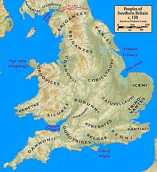
The Damnonii (also referred to as Damnii) were a Brittonic people of the late 2nd century who lived in what became the Kingdom of Strathclyde by the Early Middle Ages, and is now southern Scotland. They are mentioned briefly in Ptolemy's Geography, where he uses both of the terms "Damnonii" and "Damnii" to describe them, and there is no other historical record of them, except arguably by Gildas three centuries later.[1] Their cultural and linguistic affinity is presumed to be Brythonic. However, there is no unbroken historical record, and a partly Pictish origin is not precluded.
The Romans under Agricola had campaigned in the area in 81, and it was Roman-occupied (at least nominally) between the time that Hadrian's Wall was built (c. 122), through the building of the Antonine Wall (c. 142), until the pullback to Hadrian's Wall in 164. Ptolemy's Geography was written within this timeframe, so his account is contemporary.
Etymology
The tribe's name is nearly identical to that of the Dumnonii, a fellow British tribe who lived in Cornwall and Devon. The name is also similar to the Fir Domnann, a tribe who lived in Ireland. So far, no evidence point to the Damnonii, Dumnonii and Domnann being the same people or sharing a unique, common descent, and their similarities are likely to be based on their descriptive etymologies. Both the Dumnonii and the Domnann derive their name from the Celtic root *dumno- which means "the deep" or "inner earth". The Damnonii name could then be taken to mean "the deep ones", or the "deep valley dwellers", probably referring to their homeland being the valley of the Clyde and those of Ayrshire. A less likely theory states that the Damnonii were noted for their mining, which is where they got their names as "the deep ones" as the Clyde area has large amounts of natural ore deposits.[2]
Historiography
A medieval artist's rendition of Claudius Ptolemaeus.
The sole record of the Damnonii and their towns is their mention by Ptolemy (c. 80 – c. 168). They are found in no other source.
Ptolemy says that the towns of the Damnonii were Vanduara, Colania, Coria, Alauna, Lindum, and Victoria. However, there were no towns as such in the area at that time, so he was likely referring to Roman military camps and native strong points such as duns. Efforts have been made to determine the locations of the towns, but there is not enough information available to reach any degree of certainty, and the locations suggested are little more than guesswork.
Reflecting the lack of evidence, there is little agreement on assigning modern locations to the towns. Among the assignments made by those whose work is considered to be authoritative (to varying degrees) are those of William Baxter (1719, Glossarium Antiquitatum Britannicum),[3]William Camden (1607, Britannia),[4]John Horsley (1732, Britannia Romana),[5]William Forbes Skene (1880, Celtic Scotland, a History of Ancient Alban),[6]George Chalmers (c. 1820, Caledonia),[7] and William Roy (1793, Military Antiquities of the Romans in Britain).[8] Other historians either quote one of these as the authority for assigning locations to Ptolemy's towns, or simply assert a location in passing. A few offer lists of the assertions of the above authorities.[9]
Alauna is suggested to be the Camelon that is near and to the west of Falkirk, or at Stirling, or Kier (about 4 miles (6.4km) NNW of Stirling, on the Allan Water), or the island of Inchkeith. Colania is suggested to be Lanark or Carstairs (about 5 miles (8.0km) NE of Lanark), or some other place on the east side of Clydesdale. Coria is suggested to be Lynekirk (about 4 miles (6.4km) WNW of Peebles, or some other place on the east side of Clydesdale. Lindum is suggested to be Kirkintilloch (about 16 miles (26km) NE of Glasgow), or Linlithgow, or near Ardoch (the one about 10 miles (16km) NNW of Stirling). Victoria is suggested to be Dalginross (about 5 miles (8.0km) W of Crieff, or Abernethy (about 5 miles (8.0km) SE of Perth). Vanduara is suggested to be Paisley or Renfrew (both about 6 miles (9.7km) to the west of Glasgow), or some 20 miles south of Glasgow at Loudoun Hill.
From 1757, initial studies of the Damnonii were heavily influenced by the literary forgeryThe Description of Britain (De Situ Britanniae). The work was considered the only authoritative record of Britannia Inferior, the northern part of Roman Britain. Throughout the latter part of the 18th century until it was debunked as a forgery in 1845, it purportedly contained a lost contemporary account of the province of Britannia from a Romangeneral, new details about Roman roads in Britain in the style of the Antonine Itinerary, and an improved version of Ptolemy's map. Its credibility was such, that even after it was proven to be fake, it was still cited as a historical source until the end of the 19th century. Even Chalmers and Roy believed in its authenticity at the time they wrote.[10]De Situ Britanniae generally followed Ptolemy's map but made novel assertions regarding Damnonii towns.
Later history
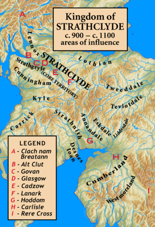
After the final retreat of Rome from Scotland in the year 210 AD, the Damnonii disappear from history, it is unknown when they centralised to form Strathclyde. Letters by Saint Patrick write of the "king of Altclut" (Ceretic Guletic) in the early 400s, with his ancestors being Damnonii leaders with Romanised names, suggesting that there was some degree of Romanisation among the elite Damnonii or renewed contact with the Empire. From this point on the Kingdom of Strathclyde seems to take the place of the Damnonii in history.
Relations with Rome
No evidence, either literary or archaeological points to any battle between the Damnonii and the Romans, suggesting then that the two co-operated. However the large surge in forest cover over Scotland in the 2nd century does point to a drop in the native population, most likely due to disease. Southern Scotland essentially acted as a frontier zone between Britannia Inferior and the Caledonians to the north. However, attacks on Hadrian's Wall later in the 2nd century may show a change in relations between the two. In 364, a people known as the Attacotti despoiled Roman Britain, along with the Irish, Picts and Saxons. It is possible the Damnonii were a part of this mysterious people.
↑ De Excidio 28: inmundae leaenae damnoniae tyrannicus catulus constantinus "Constantine, the tyrannical whelp of the unclean lioness of Damnonia". Gildas' reference is sometimes taken as referring to the Dumnonii of southwestern Britain, but for a northwestern origin argument, see for example Lloyd Laing (1975) The Archaeology of Late Celtic Britain and Ireland c.400-1200 AD, London, p102
The Dumnonii or Dumnones were a British tribe who inhabited Dumnonia, the area now known as Cornwall and Devon in the further parts of the South West peninsula of Britain, from at least the Iron Age up to the early Saxon period. They were bordered to the east by the Durotriges tribe.
The River Clyde is a river that flows into the Firth of Clyde in Scotland. It is the ninth-longest river in the United Kingdom, and the second-longest in Scotland. It runs through the major city of Glasgow. Historically, it was important to the British Empire because of its role in shipbuilding and trade. To the Romans, it was Clota, and in the early medieval Cumbric language, it was known as Clud or Clut. It was central to the Kingdom of Strathclyde.
Strathclyde was a Brittonic kingdom in northern Britain during the Middle Ages. It comprised parts of what is now southern Scotland and North West England, a region the Welsh tribes referred to as Yr Hen Ogledd. At its greatest extent in the 10th century, it stretched from Loch Lomond to the River Eamont at Penrith. Strathclyde seems to have been annexed by the Goidelic-speaking Kingdom of Alba in the 11th century, becoming part of the emerging Kingdom of Scotland.
There are many Roman sites in Great Britain that are open to the public. There are also many sites that do not require special access, including Roman roads, and sites that have not been uncovered.
Dumnonia is the Latinised name for a Brythonic kingdom that existed in Sub-Roman Britain between the late 4th and late 8th centuries CE in the more westerly parts of present-day South West England. It was centred in the area of modern Devon, but also included modern Cornwall and part of Somerset, with its eastern boundary changing over time as the gradual westward expansion of the neighbouring Anglo-Saxon kingdom of Wessex encroached on its territory. The spelling Damnonia is sometimes encountered, but that spelling is also used for the land of the Damnonii, later part of the Kingdom of Strathclyde, in present-day southern Scotland. The form Domnonia also occurs and shares a linguistic relationship with the Breton region of Domnonée.
The Durotriges were one of the Celtic tribes living in Britain prior to the Roman invasion. The tribe lived in modern Dorset, south Wiltshire, south Somerset and Devon east of the River Axe and the discovery of an Iron Age hoard in 2009 at Shalfleet, Isle of Wight gives evidence that they may also have lived in the western half of the island. After the Roman conquest, their main civitates, or settlement-centred administrative units, were Durnovaria and Lindinis. Their territory was bordered to the west by the Dumnonii; and to the east by the Belgae.
The Caledonians or the Caledonian Confederacy were a Brittonic-speaking (Celtic) tribal confederacy in what is now Scotland during the Iron Age and Roman eras. The Greek form of the tribal name gave rise to the name Caledonia for their territory. The Caledonians were considered to be a group of Britons, but later, after the Roman conquest of the southern half of Britain, the northern inhabitants were distinguished as Picts, thought to be a related people who would have also spoken a Brittonic language. The Caledonian Britons were thus enemies of the Roman Empire, which was the state then administering most of Great Britain as the Roman province of Britannia.
The Selgovae were a Celtic tribe of the late 2nd century AD who lived in what is now the Stewartry of Kirkcudbright and Dumfriesshire, on the southern coast of Scotland. They are mentioned briefly in Ptolemy's Geography, and there is no other historical record of them. Their cultural and ethnic affinity is commonly assumed to have been Brittonic.
Quintus Lollius Urbicus was a Berber governor of Roman Britain between the years 139 and 142, during the reign of the Emperor Antoninus Pius. He is named in the Historia Augusta, although it is not entirely historical, and his name appears on five Roman inscriptions from Britain; his career is set out in detail on a pair of inscriptions set up in his native Tiddis near Cirta, Numidia.
Isca Dumnoniorum, also known simply as Isca, was originally a Roman legionary fortress for the Second Augustan Legion in the Roman province of Britannia at the site of present-day Exeter in Devon.
Ardoch Roman Fort is an archaeological site just outside the village of Braco in Perthshire, Scotland, about seven miles south of Crieff.
The Novantae were a people of the late 2nd century who lived in what is now Galloway and Carrick, in southwesternmost Scotland. They are mentioned briefly in Ptolemy's Geography, and there is no other historical record of them. Excavations at Rispain Camp, near Whithorn, show that it was a large fortified farmstead occupied between 100 BC and 200 AD, indicating that the people living in the area at that time were engaged in agriculture.
The names of the Celtic Iron Age tribes in Britain were recorded by Roman and Greek historians and geographers, especially Ptolemy. Information from the distribution of Celtic coins has also shed light on the extents of the territories of the various groups that occupied the island.
The Venicones were a people of ancient Britain, known only from a single mention of them by the geographer Ptolemy c. 150 AD. He recorded that their town was 'Orrea'. This has been identified as the Roman fort of Horrea Classis, located by Rivet and Smith as Monifieth, six miles east of Dundee. Therefore, they are presumed to have lived between the Tay and the Mounth, south of Aberdeen. Andrew Breeze has suggested that the tribal name probably means "hunting hounds". A slightly differing etymology, "kindred hounds", identifies the name with Maen Gwyngwn, a region mentioned in the Gododdin.
Damnonia may refer to:
Manaw Gododdin was the narrow coastal region on the south side of the Firth of Forth, part of the Brythonic-speaking Kingdom of Gododdin in the post-Roman Era. It is notable as the homeland of Cunedda prior to his conquest of North Wales, and as the homeland of the heroic warriors in the literary epic Y Gododdin. Pressed by the Picts expanding southward and the Northumbrians expanding northward, it was permanently destroyed in the 7th century and its territory absorbed into the then-ascendant Kingdom of Northumbria.
Hadrian's Wall is a former defensive fortification of the Roman province of Britannia, begun in AD 122 in the reign of the Emperor Hadrian. Running from Wallsend on the River Tyne in the east to Bowness-on-Solway in the west of what is now northern England, it was a stone wall with large ditches in front of it and behind it that crossed the whole width of the island. Soldiers were garrisoned along the line of the wall in large forts, smaller milecastles, and intervening turrets. In addition to the wall's defensive military role, its gates may have been customs posts.
Scotland during the Roman Empire refers to the protohistorical period during which the Roman Empire interacted within the area of modern Scotland. Despite sporadic attempts at conquest and government between the 1st and 4th centuries AD, most of modern Scotland, inhabited by the Caledonians and the Maeatae, was not incorporated into the Roman Empire with Roman control over the area fluctuating.
The Vacomagi were a people of ancient Britain, known only from a single mention of them by the geographer Claudius Ptolemy. Their principal places are known from Ptolemy's map c.150 of Albion island of Britannia – from the First Map of Europe.
The architecture of Scotland in the Roman era includes all building within the modern borders of Scotland, from the arrival of the Romans in northern Britain in the first century BCE, until their departure in the fifth century CE. Ptolemy indicated that there were 19 "towns" in Caledonia, north of the Roman province of Britannia, but no clear evidence of urban settlements has been found and these were probably hillforts. There is evidence of over 1,000 such forts, most south of the Clyde-Forth line, but the majority seem to have been abandoned in the Roman period. There is also evidence of distinctive stone wheelhouses and small underground souterrains.
This page is based on this Wikipedia article Text is available under the CC BY-SA 4.0 license; additional terms may apply. Images, videos and audio are available under their respective licenses.