Smithton Company members
- Lilburn Boggs, sixth Governor of Missouri
- Richard Gentry, politician and military officer
- William Jewell, politician, physician, educator, minister
The Smithton Land Company was a group of American pioneers who in 1818 established the frontier village of Smithton, Missouri in the Boonslick region of Missouri, then the Missouri Territory. [1] In 1821 the settlement was renamed Columbia, Missouri and relocated slightly East of its original location. Smithton was the first county seat of Boone County. [2] [3] The company and town were named after Thomas Adams Smith, the receiver of the land office in Franklin, Missouri. [4]
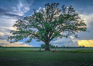
Smithton’s origin begins with the settlement of American pioneers from Kentucky and Virginia in an early 1800s region known as the Boonslick. Before 1815 settlement in the region was confined to small log forts because of the threat of Native American attack during the War of 1812. When the war ended settlers came on foot, horseback, and wagon, often moving entire households along the Boone's Lick Road and often bringing enslaved African Americans. By 1818 it was clear that the increased population would necessitate a new county be created from territorial Howard County. The Mouniteau Creek on the west and Cedar Creek on the east were obvious natural boundaries. [5]
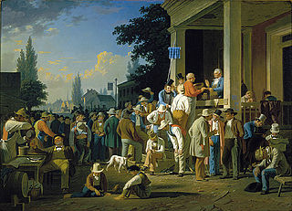
Believing it was only a matter of time before a county seat was chosen, the Smithton Land Company was formed to purchase over 2,000 acres (8.1 km2) to established the village of Smithton near the present-day intersection of Walnut and Garth. In 1819 Smithton was a small cluster of log cabins in an ancient forest of oak and hickory; chief among them was the cabin of Richard Gentry, a trustee of the Smithton Company who would become first mayor of Columbia. [6] In 1820 Boone County was formed and named after the recently deceased explorer Daniel Boone. The Missouri Legislature appointed John Gray, Jefferson Fulcher, Absalom Hicks, Lawrence Bass, and David Jackson as commissioners to select and establish a permanent county seat. [7] Smithton never had more than twenty people, and it was quickly realized that well digging was difficult because of the bedrock. Springs were discovered across the Flat Branch Creek, so in the Spring of 1821 Columbia was laid off and the inhabitants of Smithton moved their cabins to the new town. The first house in Columbia was built by Thomas Duly in 1820 at what would become Fifth and Broadway. They renamed the settlement Columbia—a historical name for the United States. [5] Columbia's permanence was ensured when it was chosen as county seat in 1821 and the Boone's Lick Road was rerouted down Broadway.
A mural in the Missouri State Capitol commemorates the first Circuit Court of Boone County in Smithton. [8] There are also murals in the Boone County Courthose and Columbia Municipal Building. A historical marker at the site of Smithton was announced in 2018. [3] There is a maker placed by the Daughters of the American Revolution commemorating Smithtons place on the Boone's Lick Road.
Smithton Middle School in Columbia is named after the village.

Columbia is a city in the U.S. state of Missouri. It is the county seat of Boone County and home to the University of Missouri. Founded in 1821, it is the principal city of the five-county Columbia metropolitan area. It is Missouri's 4th most populous with an estimated 128,555 residents in 2022.

Pettis County is a county located in west central U.S. state of Missouri. As of the 2020 census, the population was 42,980. Its county seat is Sedalia. The county was organized on January 24, 1833, and named after former U.S. Representative Spencer Darwin Pettis.
Boone County is located in the U.S. state of Missouri. Centrally located in Mid-Missouri, its county seat is Columbia, Missouri's fourth-largest city and location of the University of Missouri. As of the 2020 census, the population was 183,610, making it the state's eighth-most populous county. The county was organized November 16, 1820 and named for the then recently deceased Daniel Boone, whose kin largely populated the Boonslick area, having arrived in the 1810s on the Boone's Lick Road. Boone County comprises the Columbia Metropolitan Area. The towns of Ashland and Centralia are the second and third most populous towns in the county.

Nicholas County is a county located in the U.S. state of Kentucky. As of the 2020 census, the population was 7,537. Its county seat is Carlisle, which is also the only incorporated community in the county. Founded in 1799, the county is named for Col. George Nicholas, the "Father of the Kentucky Constitution."

The Territory of Kansas was an organized incorporated territory of the United States that existed from May 30, 1854, until January 29, 1861, when the eastern portion of the territory was admitted to the Union as the free state of Kansas.
William Becknell was an American soldier, politician, and freight operator who is credited by Americans with opening the Santa Fe Trail in 1821. He found a trail for part of the route that was wide enough for wagon trains and draft teams, making it easier for trader and emigrants along this route. The Santa Fe Trail became an early major transportation route through central North America that connected Franklin, Missouri with Santa Fe, New Mexico, serving both trading and emigrant parties. It served as a vital commercial highway from the 1820s until 1880, when the railroad was introduced to Santa Fe. Becknell made use of long-established trails made by Native Americans, and Spanish and French colonial explorers and traders for centuries before his trip.
The Columbia metropolitan area is the region centered around the City of Columbia in the U.S. state of Missouri. Located in Mid-Missouri, it consists of five counties: Boone, Audrain, Randolph, Cooper, and Howard. The population was estimated at 256,640 in 2017, making it the 4th largest metropolitan area in Missouri. Columbia is home to the University of Missouri, and is Missouri's fourth most-populous and fastest growing city, with an estimated 121,717 residents as of 2017. Other significant cities in the area include Moberly, Mexico, Boonville, Vandalia, Centralia, and Fayette.

The history of Columbia, Missouri as an American city spans two hundred years. Founded by pioneers from Kentucky in 1821 to be the county seat of Boone County. Its position astride the Boone's Lick Road led to early growth as settlers flooded into the Boonslick and eventually the West. In the 21st century Columbia is Missouri's fourth largest city and educational center.
The Boonslick, or Boone's Lick Country, is a cultural region of Missouri along the Missouri River that played an important role in the westward expansion of the United States and the development of Missouri's statehood in the early 19th century. The Boone's Lick Road, a route paralleling the north bank of the river between St. Charles and Franklin, Missouri, was the primary thoroughfare for settlers moving westward from St. Louis in the early 19th century. Its terminus in Franklin marked the beginning of the Santa Fe Trail, which eventually became a major conduit for Spanish trade in the Southwestern United States. Later it connected to the large emigrant trails, including the Oregon and California Trails, used by pioneers, gold-seekers and other early settlers of the West. The region takes its name from a salt spring or "lick" in western Howard County, used by Nathan and Daniel Morgan Boone, sons of famed frontiersman Daniel Boone.

The Boone's Lick Road or Boonslick Trail was an early 1800s transportation route from eastern to central Missouri in the United States. Running east-west on the North side and roughly parallel to the Missouri River the trail began in the river port of St. Charles. The trail played a major role in the westward expansion of the United States and the development of Missouri's statehood. The trail's eventual terminus at Franklin was the start of the better-known Santa Fe Trail. First traced by the sons of Daniel Boone, the path originally ended at a salt lick in Howard County used by the pair to manufacture salt. Today the lick is maintained as Boone's Lick State Historic Site.
Perche Township is one of ten townships in Boone County, Missouri, USA. As of the 2012, its population was 4,037. The village of Harrisburg is the only incorporated settlement inside the township.

Rocky Fork Township is one of ten townships in Boone County, Missouri, USA. The city of Hallsville is the largest settlement in the township.
Millersburg is an unincorporated community in Callaway County, in the U.S. state of Missouri. It is located near the Boone-Callaway county line on the Owl Creek tributary of Cedar Creek. The Little Dixie Lake and Little Dixie Wildlife Management Area lie on Owl Creek just north of the community. It is on Missouri Route J about four miles south of I-70.
Boone County Historical Society was established in 1924. Located in Columbia, Missouri, United States, the Boone County Historical Museum has been collecting, preserving and exhibiting artifacts and records of the people of Boone County, Missouri.
Flat Branch is a stream in Columbia, Missouri. It was the original water source for the town of Columbia and its forerunner Smithton. It is a branch of Hinkson Creek and begins Northwest of Downtown Columbia. Flat Branch Park straddles the creek between 4th Street and Providence. Flat Branch was so named on account of its low riverbanks.

Hinkson Creek is a stream in Boone County in the U.S. state of Missouri. Its middle section runs through the city of Columbia, Missouri It was named after Robert Hinkson, a pioneer citizen who lived along its banks. Several trails, conservation areas, and parks are along its path. it eventually empties into Perche Creek southwest of Columbia. The MKT Trail follows the creek in Boone County.
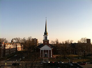
First Baptist Church is a historic Baptist church in Columbia, Missouri. In 1823, at the time of its founding, it was the first and only church in Columbia. The Church and its members have played a prominent role in civic and religious affairs in Missouri. The church's Georgian Revival style sanctuary sits conspicuously on Broadway in Downtown Columbia; it is the fourth church building and second at that location. Stephens College, formerly a baptist institution founded by church members, is across the street. First Baptist has both a traditional and contemporary Sunday services, and formerly hosted a Swahili-language congregation. The church is affiliated with the American Baptist Churches USA. In 2001, the congregation joined the Cooperative Baptist Fellowship and its longtime affiliation with the Southern Baptist Convention was ended. In 2004, the Odyssey Chamber Music Series was founded as part of a community outreach effort. In addition, the Plowman Chamber Music Competition, Columbia Handbell Ensemble, Esterhazy Quartet, and the University of Missouri School of Music utilize the sanctuary as a performance venue. William Jewell, namesake of William Jewell College in Liberty, Missouri, has been described as the leading force behind the creation of the church. The first meeting took place in the home of Charles Hardin, father of Charles Henry Hardin governor of Missouri.
Ann Hawkins Gentry was the second woman in the United States to become a postmistress as well as a leading pioneer in Columbia, Missouri. She was the wife of American politician and military officer Richard Gentry who became Columbia's first mayor.
Daniel Morgan Boone was the son of Daniel Boone and a significant American pioneer, explorer, and frontiersman in his own right. Daniel Morgan Boone was a particularly key player in the early American exploration and settlement of Missouri.

Stephens Lake Park is a park located in Columbia, Missouri, dating back to the early 19th century.
{{cite book}}: CS1 maint: location missing publisher (link){{cite web}}: CS1 maint: multiple names: authors list (link)