Related Research Articles

Smolensk is a city and the administrative center of Smolensk Oblast, Russia, located on the Dnieper River, 360 kilometers (220 mi) west-southwest of Moscow. First mentioned in 863, it is one of the oldest cities in Russia. It has a population of 316,570 (2021 Census).
Petrovichi is a rural locality in Shumyachsky District of Smolensk Oblast, Russia, located about 400 kilometers (250 mi) southwest of Moscow, 668 kilometers (415 mi) south of St Petersburg, 100 kilometers (62 mi) south of Smolensk, and 16 kilometers (9.9 mi) east of the border between Belarus and Russia. Its population in 1998 was 215.
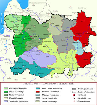
Smolensk Voivodeship was a unit of administrative division and local government in the Grand Duchy of Lithuania and later the Polish–Lithuanian Commonwealth.

Smolensk Governorate was an administrative-territorial unit (guberniya) of the Tsardom of Russia, the Russian Empire, and the Russian SFSR. It existed, with interruptions, between 1708 and 1929.

The second Smolensk operation was a Soviet strategic offensive operation conducted by the Red Army as part of the Summer-Autumn Campaign of 1943. Staged almost simultaneously with the Lower Dnieper Offensive, the offensive lasted two months and was led by General Andrei Yeremenko, commanding the Kalinin Front, and Vasily Sokolovsky, commanding the Western Front. Its goal was to clear the German presence from the Smolensk and Bryansk regions. Smolensk had been under German occupation since the first Battle of Smolensk in 1941.
Minitonas is an unincorporated urban community in the Municipality of Minitonas – Bowsman, Manitoba, Canada. It is surrounded by the Swan Valley and is located 15 km east of the Town of Swan River. The community is close to the Duck Mountain Provincial Park.

Gnyozdovo is a village in Smolensky District, Smolensk Oblast, Russia, located on the right bank of the Dnieper River twelve kilometers downstream from Smolensk, in the proximity of Katyn. The village is noted for its extensive remains of a Slavic-Varangian settlement which flourished in the 10th century as a major trade station on the trade route from the Varangians to the Greeks, see Gnezdovo for details.

Shatalovo is an air base in Pochinok, Pochinkovsky District, Smolensk Oblast of the Russian Aerospace Forces. It was part of the 6th Air and Air Defence Forces Army, Western Military District.
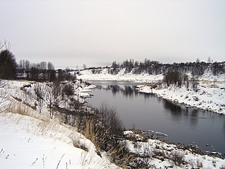
The Vazuza, a river in the Novoduginsky and Sychyovsky districts of Smolensk Oblast and in the Zubtsovsky District of Tver Oblast, Russia, becomes a right tributary of the Volga. It is 162 kilometres (101 mi) long, and its drainage basin covers 7,120 square kilometres (2,750 sq mi). Soviet engineers flooded the lower part of the river to form the Vazuza Reservoir. The towns of Sychyovka and Zubtsov are located on the banks the Vazuza. The main tributaries of the Vazuza are the Kasnya, the Gzhat, the Losmina and the Osuga (left).

The siege of Smolensk lasted almost a year between 1632 and 1633, when the Muscovite army besieged the Polish–Lithuanian city of Smolensk during the war named after that siege. Russian forces of over 25,000 under Mikhail Borisovich Shein began the siege of Smolensk on 28 October. The Polish garrison under Samuel Drucki-Sokoliński numbered about 3,000. The fortress held out for nearly a year, and in 1633 the newly-elected Polish king Władysław IV organised a relief force. In a series of fierce engagements, Commonwealth forces gradually overran the Russian field fortifications, and by 4 October the siege had broken. Shein had become besieged in his camp, and began surrender negotiations in January 1634, capitulating around 1 March.
Bibishki is a rural locality in Safonovsky District of Smolensk Oblast, Russia, located 7 kilometers (4.3 mi) southeast of Safonovo and 12 kilometers (7.5 mi) south of the M1 "Belarus" Highway, on the right bank of the Vopets River. Population: 16 ; area: 0.34 square kilometers (0.13 sq mi)
Pechersk, also spelled Pechyorsk (Печёрск), is a rural locality in Smolensky District of Smolensk Oblast, Russia, located 7 kilometers (4.3 mi) north of Smolensk. Population: 3,884 (2010 Census); 3,750 (2002 Census); 4,067.
Krasatinka is a rural locality in Krasninsky District of Smolensk Oblast, Russia. As of 2007, the population is four residents, in an area of 1.3 square kilometers (0.50 sq mi).

The Smolensk Kremlin is a fortified complex (kremlin) enclosing the center of the city of Smolensk in western Russia. The partially preserved fortress wall was built between 1595 and 1602, during the reigns of the tsars Feodor I and Boris Godunov. The length of the walls is about 6.5 kilometres (4.0 mi), of which less than the half was preserved. The fortifications were built under the supervision of the architect Fyodor Kon. The Smolensk Kremlin is classified as an architectural monument protected at the federal level, and also has a great historical significance, in particular, as the fortress protecting the Russian state from the west over centuries.

Ugransky District is an administrative and municipal district (raion), one of the twenty-five in Smolensk Oblast, Russia. It is located in the east of the oblast. The area of the district is 2,868.52 square kilometers (1,107.54 sq mi). Its administrative center is the rural locality of Ugra. Population: 8,916 ; 11,022 (2002 Census); 14,005 (1989 Soviet census). The population of Ugra accounts for 48.0% of the district's total population.
Pechersk, also spelled Pechyorsk (Печёрск), is the name of three rural localities in Smolensk Oblast, Russia:
Sloboda is the name of several rural localities in Russia.
Ray is a village in Smolensk region of Russia. Located in the central part of region, 1.5 km to the south of the motorway A141[ru], and 6 km to the south-west of Smolensk.

Talashkino is a selo in Smolensky District, Smolensk Oblast, Russia, located 18 kilometres (11 mi) southeast of Smolensk. Talashkino is notable because in the end of the 19th and in the beginning of the 20th century it belonged to Princess Maria Tenisheva, who created here an artistic colony. The buildings of the estate are currently split between Talashkino and a nearby village, Flyonovo.

Agaponovo is a rural locality in Smolensky District of Smolensk Oblast, Russia, located 30 kilometers (19 mi) north-west of Smolensk. Population of Agaponovo is 133. Anatoly Ivanovich Mishnev, a Russian politician, is a native of this village.
References
- ↑ http://admin.smolensk.ru/~monast/sels_pos/Barsukovskoe/adm/nasel_punkt.doc%5B%5D
- ↑ "-Ов-". Archived from the original on 2012-04-22. Retrieved 2012-09-08.