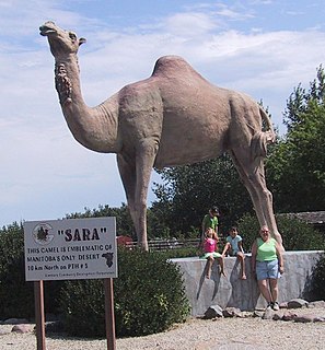
Westman is a region in the southwestern area of Manitoba, Canada. The region's urban centre is Brandon. The region comprises four of Statistics Canada's census divisions of Canada, Manitoba Census Divisions No. 5, No. 6, No. 7, and No. 15. Together they have a land area of 27,242.06 km² and had a population of 108,868 at the 2011 census.

Bítovany is a village in the Pardubice Region of the Czech Republic. It has around 400 inhabitants.

Pasieka-Kolonia is a village in the administrative district of Gmina Kraśnik, within Kraśnik County, Lublin Voivodeship, in eastern Poland.
Gabrysin is a village in the administrative district of Gmina Poświętne, within Białystok County, Podlaskie Voivodeship, in north-eastern Poland.

Nowa Trzcianna is a village in the administrative district of Gmina Nowy Kawęczyn, within Skierniewice County, Łódź Voivodeship, in central Poland. It lies approximately 3 kilometres (2 mi) north-west of Nowy Kawęczyn, 9 km (6 mi) south-east of Skierniewice, and 55 km (34 mi) east of the regional capital Łódź.

Samotnik is a village in the administrative district of Gmina Zgierz, within Zgierz County, Łódź Voivodeship, in central Poland. It lies approximately 6 kilometres (4 mi) north-east of Zgierz and 11 km (7 mi) north of the regional capital Łódź.

Tuczępy is a village in the administrative district of Gmina Grabowiec, within Zamość County, Lublin Voivodeship, in eastern Poland. It lies approximately 26 kilometres (16 mi) north-east of Zamość and 79 km (49 mi) south-east of the regional capital Lublin.
Kawęczyn-Kolonia is a village in the administrative district of Gmina Sułów, within Zamość County, Lublin Voivodeship, in eastern Poland.
Fałkowice is a village in the administrative district of Gmina Gdów, within Wieliczka County, Lesser Poland Voivodeship, in southern Poland.

Sośnica-Brzeg is a village in the administrative district of Gmina Radymno, within Jarosław County, Subcarpathian Voivodeship, in south-eastern Poland, close to the border with Ukraine. It lies approximately 7 kilometres (4 mi) south-east of Radymno, 20 km (12 mi) south-east of Jarosław, and 65 km (40 mi) east of the regional capital Rzeszów.

Straszydle is a village in the administrative district of Gmina Lubenia, within Rzeszów County, Subcarpathian Voivodeship, in south-eastern Poland. It lies approximately 6 kilometres (4 mi) south-east of Lubenia and 15 km (9 mi) south of the regional capital Rzeszów.

Kożuchów is a village in the administrative district of Gmina Wiśniowa, within Strzyżów County, Subcarpathian Voivodeship, in south-eastern Poland. It lies approximately 7 kilometres (4 mi) west of Strzyżów and 29 km (18 mi) south-west of the regional capital Rzeszów.

Janówek is a village in the administrative district of Gmina Żelechów, within Garwolin County, Masovian Voivodeship, in east-central Poland. It lies approximately 4 kilometres (2 mi) south-west of Żelechów, 22 km (14 mi) south-east of Garwolin, and 78 km (48 mi) south-east of Warsaw.

Kosobudy is a village in the administrative district of Gmina Brusy, within Chojnice County, Pomeranian Voivodeship, in northern Poland. It lies approximately 3 kilometres (2 mi) south-east of Brusy, 24 km (15 mi) north-east of Chojnice, and 79 km (49 mi) south-west of the regional capital Gdańsk.

Danachowo is a village in the administrative district of Gmina Stężyca, within Kartuzy County, Pomeranian Voivodeship, in northern Poland. It lies approximately 7 kilometres (4 mi) north-west of Stężyca, 22 km (14 mi) south-west of Kartuzy, and 50 km (31 mi) west of the regional capital Gdańsk.

Stare Łosienice is a village in the administrative district of Gmina Stężyca, within Kartuzy County, Pomeranian Voivodeship, in northern Poland. It lies approximately 9 kilometres (6 mi) north of Stężyca, 21 km (13 mi) west of Kartuzy, and 49 km (30 mi) west of the regional capital Gdańsk.

Górki is a village in the administrative district of Gmina Kamień Pomorski, within Kamień County, West Pomeranian Voivodeship, in north-western Poland. It lies approximately 9 kilometres (6 mi) south of Kamień Pomorski and 57 km (35 mi) north of the regional capital Szczecin.

Bzová is a municipality and village in Beroun District in the Central Bohemian Region of the Czech Republic.

Selišta is a village in the municipality of Sokolac, Bosnia and Herzegovina.
Aney is a village and rural commune in Niger.


