Lake Kickapoo is a reservoir located on the North Fork Little Wichita River in the Red River Basin of Archer County, Texas. It is neighbored by Archer City, Texas and Wichita Falls, Texas which reside within the Central Great Plains ecoregion.

Pumped-storage hydroelectricity (PSH), or pumped hydroelectric energy storage (PHES), is a type of hydroelectric energy storage used by electric power systems for load balancing. The method stores energy in the form of gravitational potential energy of water, pumped from a lower elevation reservoir to a higher elevation. Low-cost surplus off-peak electric power is typically used to run the pumps. During periods of high electrical demand, the stored water is released through turbines to produce electric power. Although the losses of the pumping process make the plant a net consumer of energy overall, the system increases revenue by selling more electricity during periods of peak demand, when electricity prices are highest. If the upper lake collects significant rainfall or is fed by a river then the plant may be a net energy producer in the manner of a traditional hydroelectric plant.

Dravograd is a small town in northern Slovenia, close to the border with Austria. It is the seat of the Municipality of Dravograd. It lies on the Drava River at the confluence with the Meža and the Mislinja. It is part of the traditional Slovenian provinces of Carinthia and the larger Carinthia Statistical Region.
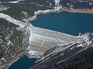
Mica Dam is a hydroelectric embankment dam spanning the Columbia River 135 kilometres north of Revelstoke, British Columbia, Canada. It was built as one of three Canadian projects under the terms of the 1964 Columbia River Treaty and is operated by BC Hydro. Completed in 1973, the Mica powerhouse had an original generating capacity of 1,805 megawatts (MW). Mica Dam, named after the nearby settlement of Mica Creek and its associated stream, in turn named after the abundance of mica minerals in the area, is one of the largest earthfill dams in the world. The reservoir created by the dam is Kinbasket Lake. Water from the dam flows south directly into Revelstoke Lake, the reservoir for the Revelstoke Dam. Mica Dam is the tallest dam in Canada and second tallest in North America after the Chicoasén Dam in Mexico and it is the farthest upstream dam on the Columbia River. The dam's underground powerhouse was the second largest in the world at the time of its construction, and was the first 500 kV installation of sulphur hexafluoride (SF6) insulated switchgear in the world.

The Fort Peck Dam is the highest of six major dams along the Missouri River, located in northeast Montana in the United States, near Glasgow, and adjacent to the community of Fort Peck. At 21,026 feet (6,409 m) in length and over 250 feet (76 m) in height, it is the largest hydraulically filled dam in the United States, and creates Fort Peck Lake, the fifth largest artificial lake in the U.S., more than 130 miles (210 km) long, 200 feet (61 m) deep, and it has a 1,520-mile (2,450 km) shoreline which is longer than the state of California's coastline. It lies within the Charles M. Russell National Wildlife Refuge. The dam and the 134-mile-long (216 km) lake are owned and operated by the U.S. Army Corps of Engineers and exist for the purposes of hydroelectric power generation, flood control, and water quality management.

Lake Oroville is a reservoir formed by the Oroville Dam impounding the Feather River, located in Butte County, northern California. The lake is situated 5 miles (8 km) northeast of the city of Oroville, within the Lake Oroville State Recreation Area, in the western foothills of the Sierra Nevada. Known as the second-largest reservoir in California, Lake Oroville is treated as a keystone facility within the California State Water Project by storing water, providing flood control, recreation, freshwater releases to assist in controlling the salinity intrusion into the Sacramento-San Joaquin Delta and protecting fish and wildlife.

The Schluchsee is a reservoir lake in the district of Breisgau-Hochschwarzwald, southeast of the Titisee in the Black Forest near Freiburg im Breisgau, Germany.

The Ilısu Dam is a concrete-face rock-fill dam on the Tigris near the village of Ilısu and along the border of Mardin and Şırnak Provinces in Turkey. It is one of the 22 dams of the Southeastern Anatolia Project and its purpose is hydroelectric power production, flood control and water storage. When operational, the dam will support a 1,200 MW power station and will form a 10.4 billion m3 reservoir. Construction of the dam began in 2006 and was originally expected to be completed by 2016. As part of the project, the much smaller Cizre Dam is to be constructed downstream for irrigation and power. The dam has drawn international controversy, because it will flood portions of ancient Hasankeyf and necessitate the relocation of people living in the region. Because of this, the dam lost international funding in 2008. Most historical structures in Hasankeyf were moved to the new Hasankeyf prior to the filling of the dam. The dam began to fill its reservoir in late July 2019. Due to rainfall, the dam has achieved water levels up to 100m above the river bed and stored 5 billion cubic meters of water. The water level had reached an elevation of 498.2m on 1 April 2020.

Carters Dam is an earthen embankment dam located south of Chatsworth in Murray County and west of Ellijay in northwestern Georgia, United States, that creates Carters Lake.

The Kajaki Dam is "an earth and rockfill embankment type dam" located on the Helmand River in the Kajaki District of Helmand Province in Afghanistan, about 161 km (100 mi) northwest of Kandahar. It has a hydroelectric power station, which is operated by the Helmand and Arghandab Valley Authority through the Ministry of Energy and Water.

The Bielerhöhe connects the Montafon valley in Vorarlberg with the Paznaun valley in Tirol. At 2,037 m above sea level, the Bielerhöhe lies in the Vorarlberg region, due north of the Silvretta Reservoir.

Lake Qaraoun is an artificial lake or reservoir located in the southern region of the Beqaa Valley, Lebanon. It was created near Qaraoun village in 1959 by building a 61 m-high (200 ft) concrete-faced rockfill dam in the middle reaches of the Litani River. The reservoir has been used for hydropower generation, domestic water supply, and for irrigation of 27,500 ha.

The Kaunertal is a municipality and alpine valley in the Landeck district in the Austrian state of Tyrol. The municipality is located about 15 km (9.3 mi) southeast of Landeck at the upper course of the Inn river.

Ranna Pumped Storage Power Station is a pumped-storage hydroelectricity power plant of Upper Austria. It is located at lake Ranna which is situated at the river Danube. The Ranna Pumped Storage Power Station uses the dammed water of the river Ranna which merges into the river Danube closely behind the power station. With its commissioning in 1925 it is one of the oldest power stations in the Austrian Mühlviertel region. As a Pumped Storage Power Station, it is able to pump water from the river Danube into the Ranna Valley storage tanks in times of weak consumer demand. This is possible because the tanks are located at a higher altitude than the river. In times of high consumer demand the water is released into the other direction where it produces electricity by running through turbines.

The Kölnbrein Dam is an arch dam in the Hohe Tauern range within Carinthia, Austria. It was constructed between 1971 and 1979 and at 200 metres (660 ft) high, it is the tallest dam in Austria. The dam's reservoir serves as the primary storage in a three-stage pumped-storage power system that consists of nine dams, four hydroelectric power plants and a series of pipeline and penstocks. The complex is owned by Verbund power company and is referred to as the Malta-Reisseck Power Plant Group. The installed capacity of the group is 1,028.5 MW and its annual generation is 1,216 gigawatt-hours (4,380 TJ).
The Markersbach Pumped Storage Power Plant is a hydroelectric power station utilizing pumped-storage technology in Markersbach, Saxony, Germany. The installed capacity of the power plant is 1,045 MW. It is Germany second largest Pumped Storage Power Plant.

The Linth–Limmern Power Stations are a system of hydroelectric power stations located south of Linthal in the canton of Glarus, Switzerland. The system uses five reservoirs and four power stations at steep variations in altitude.

The Edolo Pumped Storage Plant is located along the Oglio River just downstream of Edolo, Brescia Province in the Lombardy region of Italy. Using the pumped-storage hydroelectric method, it has an installed capacity of 1,000 megawatts (1,300,000 hp). Its generators were commissioned between April 1984 and November 1985. Lake Avio was previously completed in 1929 and Lake Benedetto completed in 1940.
The Shintoyone Pumped Storage Power Station is a large pumped-storage hydroelectric power plant in Toyone, Kitashitara, Aichi Prefecture, Japan. With an installed capacity of 1,125 megawatts (1,509,000 hp), the plant is one of the largest pumped-storage power stations in Japan.

The Handalm is a mountain located in the middle of Koralpe, standing at an elevation of 1853 meters. It is situated to the north of the Weinebene.
