Solakrossen

Last updated
Solakrossen
Sola
Village
Solakrossen.jpg
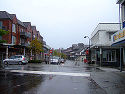
View of the village (looking northwards)
Norway Rogaland adm location map.svg
Red pog.svg
Solakrossen
Location in Rogaland county
Norway location map.svg
Red pog.svg
Solakrossen
Solakrossen (Norway)
Coordinates: 58°53′18″N05°38′57″E / 58.88833°N 5.64917°E / 58.88833; 5.64917
Country Norway
Region Western Norway
County Rogaland
District Jæren
Municipality Sola
Elevation
[1]
12 m (39 ft)
Population
c. 10,000
Time zone UTC+01:00 (CET)
  Summer (DST) UTC+02:00 (CEST)
Post Code
4050 Sola

Solakrossen or Sola is the administrative center of Sola municipality in Rogaland county, Norway. The village is located at the south end of the Hafrsfjorden on the Stavanger Peninsula, just northwest of the city of Sandnes. The large Stavanger Airport, Sola is located on the west side of the village. The village of Sørnes lies just to the north. Sola Church lies on the far western edge of Solakrossen. The population of Solakrossen is about 10,000, but the population is not separately tracked since it is part of the Stavanger/Sandnes urban area. [2] The newspaper Solabladet has been published in Solakrossen since 1991. [3] It is published in a paper edition on Thursdays and online every day. [4]

Climate

Climate data for Stavanger Airport, Sola 1991-2020 normals (7 m, extremes 1947–present, sunshine 1961-1990)
MonthJanFebMarAprMayJunJulAugSepOctNovDecYear
Record high °C (°F)12.4
(54.3)
13.9
(57.0)
17.7
(63.9)
25.2
(77.4)
29.4
(84.9)
30.5
(86.9)
32.5
(90.5)
33.5
(92.3)
29.3
(84.7)
22.3
(72.1)
16.2
(61.2)
12
(54)
33.5
(92.3)
Mean daily maximum °C (°F)4.8
(40.6)
4.6
(40.3)
6.5
(43.7)
10.4
(50.7)
13.8
(56.8)
16.3
(61.3)
18.6
(65.5)
19
(66)
16.1
(61.0)
11.9
(53.4)
8
(46)
5.6
(42.1)
11.3
(52.3)
Daily mean °C (°F)2.6
(36.7)
2.1
(35.8)
3.7
(38.7)
6.9
(44.4)
10.2
(50.4)
13
(55)
15.3
(59.5)
15.7
(60.3)
13.2
(55.8)
9.2
(48.6)
5.7
(42.3)
3.4
(38.1)
8.4
(47.1)
Mean daily minimum °C (°F)0
(32)
−0.4
(31.3)
0.9
(33.6)
3.6
(38.5)
6.8
(44.2)
9.9
(49.8)
12.4
(54.3)
12.7
(54.9)
10.3
(50.5)
6.4
(43.5)
3
(37)
0.6
(33.1)
5.5
(41.9)
Record low °C (°F)−19.8
(−3.6)
−19.2
(−2.6)
−16.2
(2.8)
−7.9
(17.8)
−2.5
(27.5)
0.6
(33.1)
4.3
(39.7)
1.2
(34.2)
−2.5
(27.5)
−5.2
(22.6)
−16.1
(3.0)
−16.1
(3.0)
−19.8
(−3.6)
Average precipitation mm (inches)118.5
(4.67)
99.6
(3.92)
80.5
(3.17)
62.5
(2.46)
62.1
(2.44)
67.3
(2.65)
91.2
(3.59)
126.5
(4.98)
132
(5.2)
148.3
(5.84)
135.2
(5.32)
132.4
(5.21)
1,256.1
(49.45)
Average precipitation days (≥ 1.0 mm)161413111010121415171617165
Average relative humidity (%)82817877757878808081828280
Mean monthly sunshine hours 48791401682262221971591418045331,538
Source 1: yr.no/met.no [5]
Source 2: NOAA - WMO averages 91-2020 Norway [6]

References

  1. "Solakrossen, Sola (Rogaland)" (in Norwegian). yr.no . Retrieved 2016-05-21.
  2. Statistisk sentralbyrå (1 January 2015). "Urban settlements. Population and area, by municipality".
  3. "Fakta om Solabladet" (in Norwegian). Solabladet.
  4. Smith-Meyer, Trond; Garvik, Olav (2024-07-04), "Solabladet", Store norske leksikon (in Norwegian), retrieved 2024-11-10
  5. https://www.yr.no/nb/historikk/graf/5-44560/Norge/Rogaland/Sola/Sola.{{cite web}}: Missing or empty |title= (help)
  6. "NOAA WMO normals Norway 1991-2020".