is a town in Drammen Municipality in Buskerud county, Norway. The town is located along the west shore of the Drammensfjorden, about 20 kilometres (12 mi) to the southeast of the town of Drammen and about 8 kilometres (5.0 mi) north of the village of Berger. The village of Klokkarstua lies about 2 kilometres (1.2 mi) to the east, across the fjord.
Luster is a municipality in Vestland county, Norway. It is located at the end of the Sognefjorden in the traditional district of Sogn. The administrative centre is the village of Gaupne. Other villages in Luster include Fortun, Hafslo, Indre Hafslo, Jostedal, Luster, Nes, Ornes, Skjolden, Solvorn, and Veitastrond.

The Sognefjord or Sognefjorden, nicknamed the King of the Fjords, is the largest and deepest fjord in Norway. Located in Vestland county in Western Norway, it stretches 205 kilometres (127 mi) inland from the ocean to the small village of Skjolden in the municipality of Luster.
Utne is a village in Ullensvang municipality in the Hardanger region of Vestland county, Norway. The village is located on the northern end of the Folgefonn Peninsula, at the confluence of the Sørfjorden and Hardangerfjorden. The village is the site of Utne Church. The village of Alsåker lies about 10 kilometres (6.2 mi) to the west on the northern shore of the peninsula and the village of Vikebygd lies about 20 kilometres (12 mi) to the south along the eastern shore of the peninsula.

The Nærøyfjord is a fjord in Aurland Municipality in Vestland county, Norway. The narrow fjord is a branch of the large Sognefjord. The 18-kilometre (11 mi) long fjord is only 500 metres (1,600 ft) wide in some parts.

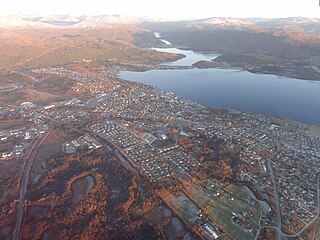
Ørnes is the administrative centre of Meløy Municipality in Nordland county, Norway. It is located along Norwegian County Road 17, about 6 kilometres (3.7 mi) south of the village of Reipå and about 5 kilometres (3.1 mi) north of the village of Eidbukta. The island of Mesøya lies just west of the village. Ørnes is a port of call along the Hurtigruten ferry route between Nesna and Bodø.

Hafslo is a former municipality in the old Sogn og Fjordane county, Norway. The 538-square-kilometre (208 sq mi) municipality existed from 1838 until its dissolution in 1963. It is located in the present-day Luster Municipality in the traditional district of Sogn. The former municipality included the villages of Kinsedalen, Ornes, and Kroken on the east side of the Lustrafjorden. It also included the villages of Solvorn, Hafslo, Joranger, and the whole Veitastrond valley on the west side of the Lustrafjorden. The municipality surrounded the lakes Hafslovatnet and Veitastrondvatnet. The administrative centre of the municipality was the village of Hafslo, where Hafslo Church was located.

Øksfjord (Norwegian), Ákšovuotna (Northern Sami), or Aksuvuono (Kven) is the administrative centre of Loppa Municipality in Finnmark county, Norway. The village is located on the east side of the Øksfjorden, just south of the mouth of the fjord. Øksfjord Church is located in the village. The village has one café and one pub, as of 2015. The village of Øksfjordbotn lies about 20 kilometres (12 mi) to the southeast, near the border with Alta Municipality.

Kjøpsvik (Norwegian) or Gásluokta (Lule Sami) is a village in Narvik Municipality in Nordland county, Norway. The village is located on the eastern shore of the Tysfjorden, north of the small village of Storå. The island of Hulløya lies off the coast of Kjøpsvik. The 0.97-square-kilometre (240-acre) village has a population (2023) of 780 and a population density of 894 inhabitants per square kilometre (2,320/sq mi).

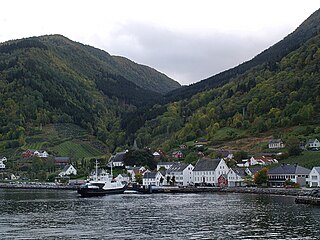
Kinsarvik is a village in the municipality of Ullensvang in Vestland county, Norway. The village is located at the end of a small bay at the confluence of the Sørfjorden and the Eid Fjord, where they join to form the main branch of the Hardangerfjorden. The village lies along the Norwegian National Road 13 and it has a ferry port with regular routes that connect it to Utne and Kvanndal across the fjord.

Bremangerlandet is an island in Bremanger Municipality in the traditional district of Nordfjord in Vestland county, Norway. The 153-square-kilometre (59 sq mi) island is one of the largest islands in the county. The highest point on the island is the 889-metre (2,917 ft) tall mountain Svartevassegga, however the cliff at Hornelen, located 1 kilometre (0.62 mi) to the east, is more well-known and has an elevation of 860 metres (2,820 ft). The 4-kilometre (2.5 mi) long lake Dalevatnet is located in the central part of the island.

Eidsdal is a village and valley in Fjord Municipality in Møre og Romsdal county, Norway. It is located along the south side of the Norddalsfjorden, about 7 kilometres (4.3 mi) southwest of the municipal centre of Sylte and the village of Norddal lies about 4 kilometres (2.5 mi) east of Eidsdal. The local church, Norddal Church is located in nearby Norddal village. Eidsdal has approximately 400 inhabitants.
Haus or Hausvik is a village in Osterøy municipality in Vestland county, Norway. The village is located on the southwestern coast of the island of Osterøy along the Sørfjorden. The village lies across the Sørfjorden from the villages of Ytre Arna and Garnes. The village of Valestrandfossen lies about 7 kilometres (4.3 mi) north along the fjord. The 0.37-square-kilometre (91-acre) village has a population (2019) of 601 and a population density of 1,624 inhabitants per square kilometre (4,210/sq mi).

Rørstad is a village in Sørfold Municipality in Nordland county, Norway. The village is located along the Sørfolda fjord, about 25 kilometres (16 mi) south of the village of Nordfold and about 15 kilometres (9.3 mi) northwest of the village of Røsvika. The historic Rørstad Church is located in the village, and worship services are held there twice each summer. The village area was located on a peninsula lying between the Nordfolda and Sørfolda fjords, just east of the uninhabited island, Prestmåsøya.

Utvik is a village in Stryn Municipality in Vestland county, Norway. The village is located on the southern shore of the Nordfjorden. The village lies about 7 kilometres (4.3 mi) southwest of the village of Innvik and about 10 kilometres (6.2 mi) north of the village of Byrkjelo. Utvik Church is located in this village. Historically, the village was an important trading post and ferry port with a regular route across the fjord. The ferry was stopped in 1936 when the new road was completed along the Nordfjorden connecting Utvik to the village of Stryn.

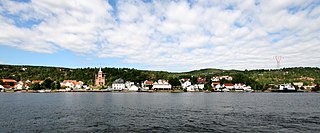
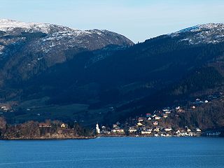
Balestrand is a village in Sogndal Municipality in Vestland county, Norway. The village is located on the northern shore of the Sognefjorden, at the mouth of the small Esefjorden. It sits about 20 kilometres (12 mi) west of the village area of Leikanger-Hermansverk and about 7 kilometres (4.3 mi) northwest of the village of Vangsnes. The small village of Tjugum lies less than 700 metres (2,300 ft) north of Balestrand, across the Esefjorden. The local Tjugum Church is located there, serving the people of the village of Balestrand.
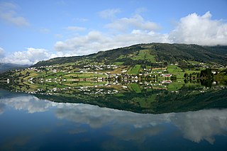
Hafslo is a village in Luster Municipality in Vestland county, Norway. The village is located on the northern shore of the lake Hafslovatnet, about 3 kilometres (1.9 mi) northwest of the village of Solvorn which sits on the shores of the Lustrafjorden. The lake Veitastrondvatnet is located to the northwest of Hafslo. The village of Sogndalsfjøra lies 15 kilometres (9.3 mi) to the south; the village of Gaupne lies about 15 kilometres (9.3 mi) to the north; and the village of Veitastrond lies about 25 kilometres (16 mi) to the northwest. The Norwegian County Road 55 runs through the village on its way from Sogndalsfjøra to Gaupne.
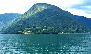
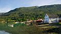
Ornes or Urnes is a village in Luster Municipality in Vestland county, Norway. The village is located on a small peninsula that juts out into the Lustrafjorden, the innermost part of the Sognefjorden. The village sits on the east side of the fjord, directly across the fjord from the village of Solvorn. Ornes is notable because it is the site of the 12th century Urnes Stave Church.

Skånevik is a village in Etne municipality in Vestland county, Norway. The village is located along the Skånevikfjorden, near the entrance to the Åkrafjorden. The village lies across the fjord from the village of Utåker in neighboring Kvinnherad municipality. The municipal centre of Etnesjøen lies about 8 kilometres (5.0 mi) straight south across a mountain, although one must drive about 22 kilometres (14 mi) around the mountain to get there.
(Norwegian) or Fuossko (Lule Sami) is a town in Fauske Municipality in Nordland county, Norway. It is also the administrative centre of Fauske Municipality. The town is located on the shore of the Skjerstad Fjord, about 60 kilometres (37 mi) east of the town of Bodø and about 40 kilometres (25 mi) west of the border with Sweden. The lake Nervatnet lies on the southeast side of the town.