Luster, Norway

Last updated
Luster Municipality
Luster kommune
Lyster herred  (historic name)
Luster sognefjord norway.jpg
View of the village of Luster
Flag of Luster.gif
Luster komm.svg
Norway Counties Vestland Position.svg
Vestland within Norway
NO 4644 Luster.svg
Luster within Vestland
Coordinates: 61°29′38″N07°19′46″E / 61.49389°N 7.32944°E / 61.49389; 7.32944
Country Norway
County Vestland
District Sogn
Established1 Jan 1838
  Created as Formannskapsdistrikt
Administrative centre Gaupne
Government
  Mayor (2023)Andreas Wollnick Wiese (Sp)
Area
  Total2,706.34 km2 (1,044.92 sq mi)
  Land2,596.74 km2 (1,002.61 sq mi)
  Water109.61 km2 (42.32 sq mi)  4.1%
  Rank#17 in Norway
Population
 (2023)
  Total5,302
  Rank#176 in Norway
  Density2/km2 (5/sq mi)
  Change (10 years)
Increase2.svg +5.2%
Demonym Lustring [1]
Official language
[2]
   Norwegian form Nynorsk
Time zone UTC+01:00 (CET)
  Summer (DST) UTC+02:00 (CEST)
ISO 3166 code NO-4644 [3]
Website Official website

Luster is a municipality in Vestland county, Norway. It is located at the end of the Sognefjorden in the traditional district of Sogn. The administrative centre is the village of Gaupne. Other villages in Luster include Fortun, Hafslo, Indre Hafslo, Jostedal, Luster, Nes, Ornes, Skjolden, Solvorn, and Veitastrond.

Contents

Luster is centered around the inner branch of the Sognefjord, which is called the Lustrafjorden. Its landscape includes fjords, steep mountains, water-abundant waterfalls, blue glaciers, and valleys. Both Jostedalsbreen National Park and Breheimen National Park are partially located in this municipality. The Sognefjellsvegen road goes over a mountain pass in eastern Luster.

The 2,706-square-kilometre (1,045 sq mi) municipality is the 17th largest by area out of the 356 municipalities in Norway. Luster is the 176th most populous municipality in Norway with a population of 5,302. The municipality's population density is 2 inhabitants per square kilometre (5.2/sq mi) and its population has increased by 5.2% during the previous 10-year period. [4] [5]

In 2016, the chief of police for Vestlandet formally suggested a reconfiguration of police districts and stations. He proposed that the police station in Luster be closed. [6]

General information

View of the Fortun area Fortun 2010.jpg
View of the Fortun area
Norwegian sheep and Luster landscape Norway sheep and landscape.jpg
Norwegian sheep and Luster landscape
Old Gaupne Church Gaupne gamle kirke.jpg
Old Gaupne Church

Lyster was established as a municipality on 1 January 1838 (see formannskapsdistrikt law). The original municipality was identical to the Lyster parish (prestegjeld) with the sub-parishes (sokn) of Fortun, Dale, Nes, and Gaupne. During the 1960s, there were many municipal mergers across Norway due to the work of the Schei Committee. On 1 January 1963, the neighboring municipalities of Hafslo and Jostedal were merged with Luster, forming a much larger municipality. After the merger, Luster had 5,854 residents. [7]

Since the consolidation of the three municipalities of Hafslo, Jostedal and Luster in 1963, the area has been characterized by scattered rural settlements and large distances between these settlements. Luster was the largest municipality by area in the old Sogn og Fjordane county. [8]

On 1 January 2020, the municipality became part of the newly created Vestland county after Sogn og Fjordane and Hordaland counties were merged.

Name

The municipality (originally the parish) is named after the Lustrafjorden (Old Norse : Lústr) and the village of Luster which grew up along the fjord. The name is derived from the word ljóss which means "light" or "bright", referring to the bright color of the water from the glaciers. [9] Historically, the name of the municipality was spelled Lyster. On 3 November 1917, a royal resolution changed the spelling of the name of the municipality to Luster. [10]

Coat of arms

The coat of arms was granted on 20 April 1990. The official blazon is "Azure, a tilia curled argent forming an annulet" (Norwegian : På blå grunn ein sølv linderanke lagt i sirkel). This means the arms have a blue field (background) and the charge is a tilia branch curled into a circle. The charge has a tincture of argent which means it is commonly colored white, but if it is made out of metal, then silver is used. The arms are inspired by an old woodcarving found in the Urnes Stave Church which is located in the municipality. The arms were designed by Inge Rotevatn from Nordfjordeid. The municipal flag has the same design as the coat of arms. [11] [12] [13]

Churches

The Church of Norway has eight parishes (sokn) within the municipality of Luster. It is part of the Sogn prosti (deanery) in the Diocese of Bjørgvin. [14]

Churches in Luster
Parish (sokn)Church nameLocation of the churchYear built
Dale Dale Church Luster 1250
Fet og Joranger Fet Church Fet 1894
Joranger Church Joranger 1660
Fortun Fortun Church Fortun 1879
Gaupne Gaupne Church Gaupne 1908
Old Gaupne Church 1647
Hafslo Hafslo Church Hafslo 1878
Veitastrond Chapel Veitastrond 1928
Jostedal Jostedal Church Jostedal 1660
Nes Nes Church Nes 1909
Solvorn Solvorn Church Solvorn 1883
Urnes Stave Church Ornes 1130

Government

Luster Municipality is responsible for primary education (through 10th grade), outpatient health services, senior citizen services, welfare and other social services, zoning, economic development, and municipal roads and utilities. The municipality is governed by a municipal council of directly elected representatives. The mayor is indirectly elected by a vote of the municipal council. [15] The municipality is under the jurisdiction of the Sogn og Fjordane District Court and the Gulating Court of Appeal.

Municipal council

The municipal council (Kommunestyre) of Luster is made up of 25 representatives that are elected to four year terms. The tables below show the current and historical composition of the council by political party.

Luster kommunestyre 20232027 [16]   
Party name (in Nynorsk)Number of
representatives
  Labour Party (Arbeidarpartiet)8
  Progress Party (Framstegspartiet)1
  Conservative Party (Høgre)3
  Christian Democratic Party (Kristeleg Folkeparti)2
  Centre Party (Senterpartiet)9
  Socialist Left Party (Sosialistisk Venstreparti)1
  Liberal Party (Venstre)1
Total number of members:25
Luster kommunestyre 20192023 [17]   
Party name (in Nynorsk)Number of
representatives
  Labour Party (Arbeidarpartiet)6
  Progress Party (Framstegspartiet)1
  Conservative Party (Høgre)3
  Christian Democratic Party (Kristeleg Folkeparti)1
  Centre Party (Senterpartiet)13
  Liberal Party (Venstre)1
Total number of members:25
Luster kommunestyre 20152019 [18]   
Party name (in Nynorsk)Number of
representatives
  Labour Party (Arbeidarpartiet)7
  Progress Party (Framstegspartiet)1
  Conservative Party (Høgre)2
  Christian Democratic Party (Kristeleg Folkeparti)1
  Centre Party (Senterpartiet)13
  Liberal Party (Venstre)1
Total number of members:25
Luster kommunestyre 20112015 [19]   
Party name (in Nynorsk)Number of
representatives
  Labour Party (Arbeidarpartiet)8
  Progress Party (Framstegspartiet)3
  Conservative Party (Høgre)3
  Christian Democratic Party (Kristeleg Folkeparti)2
  Centre Party (Senterpartiet)7
  Liberal Party (Venstre)2
Total number of members:25
Luster kommunestyre 20072011 [18]   
Party name (in Nynorsk)Number of
representatives
  Labour Party (Arbeidarpartiet)10
  Progress Party (Framstegspartiet)3
  Conservative Party (Høgre)2
  Christian Democratic Party (Kristeleg Folkeparti)4
  Centre Party (Senterpartiet)7
  Socialist Left Party (Sosialistisk Venstreparti)1
  Liberal Party (Venstre)2
Total number of members:29
Luster kommunestyre 20032007 [18]   
Party name (in Nynorsk)Number of
representatives
  Labour Party (Arbeidarpartiet)12
  Progress Party (Framstegspartiet)3
  Conservative Party (Høgre)1
  Christian Democratic Party (Kristeleg Folkeparti)4
  Centre Party (Senterpartiet)6
  Socialist Left Party (Sosialistisk Venstreparti)1
  Liberal Party (Venstre)2
Total number of members:29
Luster kommunestyre 19992003 [18]   
Party name (in Nynorsk)Number of
representatives
  Labour Party (Arbeidarpartiet)17
  Liberal Party (Venstre)1
 Joint list of the Conservative Party (Høgre), Christian Democratic Party (Kristeleg Folkeparti), and Centre Party  (Senterpartiet)11
Total number of members:29
Luster kommunestyre 19951999 [20]   
Party name (in Nynorsk)Number of
representatives
  Labour Party (Arbeidarpartiet)15
  Conservative Party (Høgre)1
  Christian Democratic Party (Kristeleg Folkeparti)4
  Centre Party (Senterpartiet)7
  Liberal Party (Venstre)2
Total number of members:29
Luster kommunestyre 19911995 [21]   
Party name (in Nynorsk)Number of
representatives
  Labour Party (Arbeidarpartiet)18
  Conservative Party (Høgre)2
  Christian Democratic Party (Kristeleg Folkeparti)5
  Centre Party (Senterpartiet)10
  Liberal Party (Venstre)1
  Local list for Hafslo (Bygdalista for Hafslo)1
Total number of members:37
Luster kommunestyre 19871991 [22]   
Party name (in Nynorsk)Number of
representatives
  Labour Party (Arbeidarpartiet)16
  Conservative Party (Høgre)3
  Christian Democratic Party (Kristeleg Folkeparti)5
  Centre Party (Senterpartiet)9
  Liberal Party (Venstre)2
  Local list for Hafslo (Bygdalista for Hafslo)2
Total number of members:37
Luster kommunestyre 19831987 [23]   
Party name (in Nynorsk)Number of
representatives
  Labour Party (Arbeidarpartiet)16
  Conservative Party (Høgre)4
  Christian Democratic Party (Kristeleg Folkeparti)5
  Centre Party (Senterpartiet)7
  Liberal Party (Venstre)2
  Local list for Hafslo (Bygdalista for Hafslo)3
Total number of members:37
Luster kommunestyre 19791983 [24]   
Party name (in Nynorsk)Number of
representatives
  Labour Party (Arbeidarpartiet)14
  Conservative Party (Høgre)3
  Christian Democratic Party (Kristeleg Folkeparti)6
  Centre Party (Senterpartiet)9
  Liberal Party (Venstre)2
  Local list for Hafslo (Bygdalista for Hafslo)3
Total number of members:37
Luster kommunestyre 19751979 [25]   
Party name (in Nynorsk)Number of
representatives
  Labour Party (Arbeidarpartiet)17
  Conservative Party (Høgre)1
  Christian Democratic Party (Kristeleg Folkeparti)6
  Centre Party (Senterpartiet)10
  Liberal Party (Venstre)1
  Cross-party common list (Tverrpolitisk Samlingsliste)2
Total number of members:37
Luster kommunestyre 19711975 [26]   
Party name (in Nynorsk)Number of
representatives
  Labour Party (Arbeidarpartiet)16
  Conservative Party (Høgre)1
  Christian Democratic Party (Kristeleg Folkeparti)6
  Centre Party (Senterpartiet)9
  Liberal Party (Venstre)3
  Joint List(s) of Non-Socialist Parties (Borgarlege Felleslister)2
Total number of members:37
Luster kommunestyre 19671971 [27]   
Party name (in Nynorsk)Number of
representatives
  Labour Party (Arbeidarpartiet)15
  Conservative Party (Høgre)1
  Christian Democratic Party (Kristeleg Folkeparti)5
  Centre Party (Senterpartiet)9
  Liberal Party (Venstre)5
  Local List(s) (Lokale lister)2
Total number of members:37
Luster kommunestyre 19631967 [28]   
Party name (in Nynorsk)Number of
representatives
  Labour Party (Arbeidarpartiet)16
  Joint List(s) of Non-Socialist Parties (Borgarlege Felleslister)19
  Local List(s) (Lokale lister)2
Total number of members:37
Luster heradsstyre 19591963 [29]   
Party name (in Nynorsk)Number of
representatives
  Labour Party (Arbeidarpartiet)12
  Conservative Party (Høgre)1
  Christian Democratic Party (Kristeleg Folkeparti)3
  Centre Party (Senterpartiet)7
  Liberal Party (Venstre)2
Total number of members:25
Luster heradsstyre 19551959 [30]   
Party name (in Nynorsk)Number of
representatives
  Labour Party (Arbeidarpartiet)11
  Conservative Party (Høgre)1
  Christian Democratic Party (Kristeleg Folkeparti)4
  Farmers' Party (Bondepartiet)7
  Liberal Party (Venstre)2
Total number of members:25
Luster heradsstyre 19511955 [31]   
Party name (in Nynorsk)Number of
representatives
  Labour Party (Arbeidarpartiet)17
  Liberal Party (Venstre)7
  Joint List(s) of Non-Socialist Parties (Borgarlege Felleslister)12
Total number of members:36
Luster heradsstyre 19471951 [32]   
Party name (in Nynorsk)Number of
representatives
  Labour Party (Arbeidarpartiet)16
  Farmers' Party (Bondepartiet)6
  Liberal Party (Venstre)3
  Joint List(s) of Non-Socialist Parties (Borgarlege Felleslister)10
  Local List(s) (Lokale lister)1
Total number of members:36
Luster heradsstyre 19451947 [33]   
Party name (in Nynorsk)Number of
representatives
  Labour Party (Arbeidarpartiet)6
  List of workers, fishermen, and small farmholders (Arbeidarar, fiskarar, småbrukarar liste)11
  Joint List(s) of Non-Socialist Parties (Borgarlege Felleslister)8
  Local List(s) (Lokale lister)11
Total number of members:36
Luster heradsstyre 19371941* [34]   
Party name (in Nynorsk)Number of
representatives
  Labour Party (Arbeidarpartiet)18
  Farmers' Party (Bondepartiet)7
  Liberal Party (Venstre)2
 Joint list of the Farmers' Party  (Bondepartiet) and the Liberal Party  (Venstre)6
  Joint List(s) of Non-Socialist Parties (Borgarlege Felleslister)2
  Local List(s) (Lokale lister)1
Total number of members:36
Note: Due to the German occupation of Norway during World War II, no elections were held for new municipal councils until after the war ended in 1945.

Mayors

The mayors of Luster: [35]

  • 1838-1841: Mons S. Fuhr
  • 1842-1843: Peder Lavold
  • 1844-1845: Hans Hanson Urdahl, Sr.
  • 1846-1853: Sølfest Urdahl
  • 1854-1861: Mons S. Fuhr
  • 1862-1863: Hans Hanson Urdahl, Sr.
  • 1864-1865: John Z. Næs
  • 1866-1866: Sølfest Urdahl
  • 1867-1867: John Z. Næs
  • 1868-1869: Sølfest Urdahl
  • 1870-1875: John Z. Næs
  • 1876-1877: Hans Hanson Urdahl, Jr.
  • 1878-1881: John Z. Næs
  • 1888-1893: Hans Hanson Urdahl, Jr.
  • 1894-1897: Sjur O. Fuhr
  • 1898-1898: Hans J. Næss
  • 1899-1900: Sjur T. Næss
  • 1901-1904: Sjur O. Fuhr
  • 1905-1906: Sjur T. Næss
  • 1907-1910: Per Urdahl
  • 1911-1916: Halvard Drægni
  • 1917-1919: Johannes Fladhammer
  • 1920-1921: Halvard Drægni
  • 1922-1922: Hermann Prestegård
  • 1923-1925: Jens Døsen
  • 1926-1927: Halvard Drægni
  • 1928-1928: Olav Tjønn
  • 1929-1931: Anders Molland
  • 1932-1934: Hermann Prestegård
  • 1935-1941: Anders Molland
  • 1942-1944: Eirik Weka
  • 1946-1947: Hans Prestegård
  • 1948-1959: Olav Listou
  • 1960-1975: Anders Bjørk (Sp)
  • 1976-1977: Kåre Øvregard (Ap)
  • 1978-1979: Knut P. Nes (KrF)
  • 1980-1989: Jan Haugen (Sp)
  • 1990-2003: Ernst Weum (Ap)
  • 2003-2011: Torodd Urnes (KrF)
  • 2011-2023: Ivar Kvalen (Sp)
  • 2023-present: Andreas Wollnick Wiese (Sp) [36]

Geography

Note people entering the ice cave in the glacier Nigardsbreen--this gives some perspective on the size of the glacier as the cave shows in the other picture. Nigardsbreen-Norway-close-up.jpg
Note people entering the ice cave in the glacier Nigardsbreenthis gives some perspective on the size of the glacier as the cave shows in the other picture.
The glacier Nigardsbreen and the lake Nigardsbrevatnet in Luster. Nigardsbreen-Norway.jpg
The glacier Nigardsbreen and the lake Nigardsbrevatnet in Luster.

Location

Luster, one of the largest municipalities in southern Norway, is located in the glacial mountains where the Sognefjorden begins its path to the North Sea. The fjord is fed by many large glaciers such as the Harbardsbreen, Holåbreen, Jostedalsbreen, Nigardsbreen, Spørteggbreen, and others. [37]

It is bordered by four municipalities in Vestland county: Stryn to the north, Sunnfjord to the west, Sogndal to the southwest, and Årdal to the southeast. It is also bordered by three municipalities in Innlandet county: Skjåk to the northeast and by Lom and Vang to the east.

Feigumfoss waterfall

With a vertical drop of 218 metres (715 ft), the Feigumfoss Waterfall is one of the highest in Scandinavia. [38]

Mountains

The Hurrungane, Breheimen, and Jotunheimen mountains cover parts of the municipality. Store Skagastølstind (or Storen) is the third highest mountain peak in Norway at 2,405 metres (7,890 ft) high, and it is located on the southern border of Luster and Årdal. It is part of the Hurrungane mountain range which contains some of the most alpine peaks in Norway.

Mountains of Luster over 2,000 metres (6,600 ft) [38]
MountainHeightMountainHeight
Store Skagastølstind 2,405 m (7,890 ft)Store Dyrhaugstind2,147 m (7,044 ft)
Store Styggedalstinden 2,387 m (7,831 ft)Mjølkedalstind2,137 m (7,011 ft)
Jervvasstind 2,351 m (7,713 ft)Store Ringstind2,124 m (6,969 ft)
Sentraltind 2,351 m (7,713 ft) Tverrådalskyrkja 2,088 m (6,850 ft)
Vetle Skagastølstind 2,340 m (7,680 ft) Lodalskåpa 2,083 m (6,834 ft)
Midtre Skagastølstind 2,284 m (7,493 ft)Store Soleiebotntind2,083 m (6,834 ft)
Store Austanbotntind 2,203 m (7,228 ft)Søre Dyrhaugstind2,072 m (6,798 ft)
Store Raudalseggi2,168 m (7,113 ft) Fannaråken 2,068 m (6,785 ft)
Store Raudalstind2,157 m (7,077 ft)Stetind i Jotunheimen2,020 m (6,630 ft)
Uranostind2,157 m (7,077 ft) Brenibba 2,018 m (6,621 ft)

Lakes and Rivers

There are notable lakes such as Veitastrondsvatnet, Austdalsvatnet, Styggevatnet, Tunsbergdalvatnet, Prestesteinsvatnet, and Hafslovatnet. There are also many big waterfalls such as the Feigumfoss waterfall at 218 metres (715 ft) tall. The river Jostedøla runs through the Jostedal valley and empties into the fjord at Gaupne.

Storelvi with Austerdalen (right) and Langedalen (left) Austerdalen LC0364.jpg
Storelvi with Austerdalen (right) and Langedalen (left)

Glaciers

The Jostedalsbreen glacier (including the arm called Nigardsbreen) is the biggest glacier in continental Europe, the highest point on it is Høgste Breakulen. It is located west of Jostedal, north of Gaupne, in Jostedalsbreen National Park, much of which is located in the municipality of Luster. [38] Other glaciers include the Austerdalsbreen, Harbardsbreen and Spørteggbreen.

Economy

The inhabitants of Luster make their living by farming, growing berries and fruit, tourism, and hydroelectricity. Jøstedal and Fortun have large hydroelectric power stations. Summer tourism is quite busy. Tourist activities include mountain climbing, skiing, fishing, hiking, and hunting. [38] The Sognefjellsvegen tourist road passes through Luster.

River fishing

Fishing permits (for salmon fishing) are sold for use on specific rivers, including Årøy-elva. [39]

Culture and education

Historic churches

Urnes Stave Church Urnes Stave Church 2.jpg
Urnes Stave Church
Urnes Stave Church

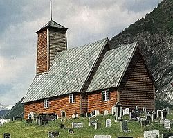
Urnes Stave Church was built around 1150 and is Norway's oldest Stave church. The Church lies majestically on the top of Urnes. The Stave church is one of four Norwegian Churches on UNESCO`s list of the most precious cultural monuments in the world.

The Stave churches are constructions of high quality, richly decorated with carvings. In virtually all of them the door frames are decorated from top to bottom with carvings. This tradition of rich ornamentation appears to go back to the animal carvings of the Viking age. The dragons are lovingly executed and transformed into long-limbed creatures of fantasy, here and there entwined with tendrils of vine, with winding stems and serrated leaves. The elaborate designs are executed with supreme artistic skill. The stave church doorways are, therefore, among the most distinctive works of art to be found in Norway. However, it is difficult to connect them with the Christian gospel. [38]

Old Gaupne Church

The Old Gaupne Church is a magnificent church that was built in 1647 on a hill directly opposite Gaupne centre. [38]

Dale Church

Dale Church is a stone church that was built in gothic style in the year 1250. [38]

Breheim center

The Breheim Center contains a comprehensive exhibition. A journey through 20,000 years - from the Ice age to the present day, an audio/visual show takes visitors inside the glacier. Glacier boat M/S "Jostedalsrypa" crosses the Nigard Glacier Lake. There are internationally approved guides, glacier and climbing courses, and ski-trips. [38]

Education

In 2020, 32% of the municipality's applicants for [secondary schooling] videregående skole , sought [non-vocational schooling], studiespesialisering; [67% or] the rest of the applicants sought vocational schooling. [40]

Notable people

Gerhard Munthe, 1817 Johannes Flintoe - Gerhard Munthe.png
Gerhard Munthe, 1817

Twin cities/towns

Luster has sister city agreements with the following places:

Related Research Articles

<span class="mw-page-title-main">Sogn og Fjordane</span> Former county of Norway

Sogn og Fjordane was, up to 1 January 2020, a county in western Norway, when it was merged to become part of Vestland county. Bordering previous counties Møre og Romsdal, Oppland, Buskerud, and Hordaland, the county administration was in the village of Hermansverk in Leikanger municipality. The largest town in the county was Førde.

<span class="mw-page-title-main">Gulen</span> Municipality in Vestland, Norway

is a municipality in the western part of Vestland county, Norway. It is part of the traditional district of Sogn. The administrative center of the municipality is the village of Eivindvik. Other villages in Gulen include Brekke, Byrknes, Dalsøyra, Dingja, Instefjord, Mjømna, Rutledal, and Ytre Oppedal.

<span class="mw-page-title-main">Vik, Sogn</span> Municipality in Vestland, Norway

Vik is a municipality in Vestland county, Norway. It is located on the southern shore of the Sognefjorden in the traditional district of Sogn. The administrative center of Vik is the village of Vikøyri. Other villages in the municipality include Feios, Fresvik, Nese, and Vangsnes.

<span class="mw-page-title-main">Balestrand</span> Former municipality in Sogn og Fjordane, Norway

Balestrand is a former municipality in Sogn og Fjordane county, Norway. It was located on the northern shore of the Sognefjorden in the traditional district of Sogn. The administrative center was the village of Balestrand. Other villages in the municipality included Ese, Kvamme, Låne, Sæle, Tjugum, and Vetlefjorden.

<span class="mw-page-title-main">Leikanger</span> Former municipality in Sogn og Fjordane, Norway

Leikanger is a former municipality in Sogn og Fjordane county, Norway. It was located on the northern shore of the Sognefjorden in the traditional district of Sogn. The administrative center was the village of Hermansverk, which also was the administrative center of the old Sogn og Fjordane county.

<span class="mw-page-title-main">Sogndal</span> Municipality in Vestland, Norway

Sogndal is a municipality in Vestland county, Norway. It is located on the northern shore of the Sognefjorden in the traditional district of Sogn. The village of Hermansverk is the administrative center of Sogndal municipality. Other villages include Kaupanger, Kjørnes, Fimreite, Nornes, and Fjærland. Sogndal Airport, Haukåsen is located 10 kilometres (6.2 mi) southwest of Kaupanger.

<span class="mw-page-title-main">Aurland</span> Municipality in Vestland, Norway

Aurland is a municipality in the county of Vestland, Norway. It is located on the south side of the Sognefjorden in the traditional district of Sogn. The administrative center is the village of Aurlandsvangen. Other villages include Bakka, Flåm, Undredal, and Gudvangen.

<span class="mw-page-title-main">Lærdal</span> Municipality in Vestland, Norway

Lærdal is a municipality in Vestland county, Norway. It is located on the south side of the Sognefjorden in the traditional district of Sogn. The administrative center of the municipality is the village of Lærdalsøyri. The old Filefjell Kongevegen road passes through Lærdal on its way to Valdres and later to Oslo.

<span class="mw-page-title-main">Askvoll</span> Municipality in Vestland, Norway

is a municipality in Vestland county, Norway. It is located in the traditional district of Sunnfjord. The administrative centre is the village of Askvoll. Other villages in the municipality include Holmedal, Kvammen, and Stongfjorden. The most important industries in Askvoll today are Helle Knivfabrikk, Bulandet Fiskeindustri, and Sigurd Løkeland Hermetikkfabrikk.

<span class="mw-page-title-main">Fjaler</span> Municipality in Vestland, Norway

Fjaler is a municipality in the county of Vestland, Norway. It is located in the traditional district of Sunnfjord. The administrative centre is the village of Dale. Other places in Fjaler include Espedal, Flekke, Folkestad, Guddal, and Hellevika.

<span class="mw-page-title-main">Jølster</span> Former municipality in Sogn og Fjordane, Norway

Jølster is a former municipality in Sogn og Fjordane county, Norway. It was located in the traditional district of Sunnfjord. The administrative centre was the village of Skei. Other villages in the municipality included Helgheim, Ålhus, Vassenden, and Langhaugane.

<span class="mw-page-title-main">Førde</span> Former municipality in Sogn og Fjordane county, Norway

Førde is a former municipality in the county of Sogn og Fjordane, Norway. It was located in the traditional district of Sunnfjord. The administrative center was the town of Førde which in 2016 had 10,255 inhabitants. Other villages in Førde municipality included Bruland, Holsen, Moskog, and Haukedalen. The Øyrane area in the town of Førde was a large industrial/commercial area for the region. The European Route E39 highway passed through the municipality, and it passed by the lake Holsavatnet.

<span class="mw-page-title-main">Bremanger</span> Municipality in Vestland, Norway

Bremanger is a municipality in Vestland county, Norway. The village of Svelgen is the administrative centre of the municipality. Other villages include Bremanger, Berle, Davik, Isane, Kalvåg, Svelgen, Rugsund, and Ålfoten. Bremanger is the only municipality in Vestland, which is located in two districts. The northern and eastern parts comprising the villages of Oldeide, Berle, Rugsund, Davik, Isane, and Ålfoten is located in the Nordfjord region, while the villages of Bremanger, Kalvåg, Svelgen, Sørgulen, and Botnane are located in the Sunnfjord region. Politically, the municipality works with the Nordfjord region in the council of Nordfjord municipalities.

<span class="mw-page-title-main">Selje</span> Former municipality in Sogn og Fjordane, Norway

Selje is a former municipality in the old Sogn og Fjordane county, Norway and was located in the traditional district of Nordfjord. The village of Selje was the administrative center this municipality. Other villages and neighborhoods in the municipality included Barmen, Ervik, Flatraket, Hoddevik, Hoddevika, Håvik, and Leikanger. On 1 January 2020 the municipality became part of the new Stad Municipality in the newly formed Vestland county.

<span class="mw-page-title-main">Gloppen</span> Municipality in Vestland, Norway

Gloppen is a municipality in the county of Vestland, Norway. It is located in the traditional district of Nordfjord. Gloppen is generally subdivided into three areas: Hyen in the west, Gloppen in the center, and Breim in the east.

<span class="mw-page-title-main">Stryn</span> Municipality in Vestland, Norway

Stryn is a municipality in the county of Vestland, Norway. It is located in the traditional district of Nordfjord. The administrative center of the municipality is the village of Stryn. The municipality is located along the innermost part of the Nordfjorden. Some of the main villages in Stryn include Loen, Innvik, Utvik, Randabygda, Olden, and Flo.

<span class="mw-page-title-main">Hafslo</span> Former municipality in Sogn og Fjordane county, Norway

Hafslo is a former municipality in the old Sogn og Fjordane county, Norway. The 538-square-kilometre (208 sq mi) municipality existed from 1838 until its dissolution in 1963. It is located in the present-day Luster Municipality in the traditional district of Sogn. The former municipality included the villages of Kinsedalen, Ornes, and Kroken on the east side of the Lustrafjorden. It also included the villages of Solvorn, Hafslo, Joranger, and the whole Veitastrond valley on the west side of the Lustrafjorden. The municipality surrounded the lakes Hafslovatnet and Veitastrondvatnet. The administrative centre of the municipality was the village of Hafslo, where Hafslo Church was located.

<span class="mw-page-title-main">Breim</span> Former municipality in Vestland, Norway

Breim is a former municipality in the old Sogn og Fjordane county, Norway. It is part of the traditional district of Nordfjord in the eastern part of the present-day Gloppen Municipality which is now in Vestland county. The 359-square-kilometre (139 sq mi) municipality existed from 1886 until 1964. The administrative center was the village of Reed.

<span class="mw-page-title-main">Jostedal</span> Former municipality in Sogn og Fjordane county, Norway

Jostedal is a former municipality in the old Sogn og Fjordane county in Norway. The 533-square-kilometre (206 sq mi) municipality existed from 1838 until its dissolution in 1963. It was located in the Jostedalen valley in the northern part of the present-day municipality of Luster, in Vestland county, north of the village of Gaupne. The administrative centre was also located near the Jostedal Church in the central part of the valley.

<span class="mw-page-title-main">Innvik</span> Former municipality in Sogn og Fjordane county, Norway

Innvik is a former municipality in the old Sogn og Fjordane county in Norway. The 511-square-kilometre (197 sq mi) municipality existed from 1838 until 1965. Innvik is located in the present-day Stryn Municipality in Vestland county, encompassing about the western third of the present municipality. Innvik included both sides of the Nordfjorden, from Randabygda in the west to just west of the village of Stryn. It stretched from the border with Hornindal Municipality in the north, through the Oldedalen valley all the way to the Jostedalsbreen glacier in the south.

References

  1. "Navn på steder og personer: Innbyggjarnamn" (in Norwegian). Språkrådet.
  2. "Forskrift om målvedtak i kommunar og fylkeskommunar" (in Norwegian). Lovdata.no.
  3. Bolstad, Erik; Thorsnæs, Geir, eds. (26 January 2023). "Kommunenummer". Store norske leksikon (in Norwegian). Kunnskapsforlaget.
  4. Statistisk sentralbyrå. "Table: 06913: Population 1 January and population changes during the calendar year (M)" (in Norwegian).
  5. Statistisk sentralbyrå. "09280: Area of land and fresh water (km²) (M)" (in Norwegian).
  6. Fjelltveit, Ingvild; Raunholm, Per Vidar (20 December 2016). "Foreslår å legge ned 17 lensmannskontor i Vest politidistrikt". NRK Hordaland (in Norwegian). Retrieved 20 October 2017.
  7. Jukvam, Dag (1999). Historisk oversikt over endringer i kommune- og fylkesinndelingen (PDF) (in Norwegian). Statistisk sentralbyrå. ISBN   9788253746845.
  8. Natvik, Oddvar (9 February 2005). "Some historical data on the 26 Kommunes". Archived from the original on 13 June 2008. Retrieved 23 June 2008.
  9. Rygh, Oluf (1919). Norske gaardnavne: Nordre Bergenhus amt (in Norwegian) (12 ed.). Kristiania, Norge: W. C. Fabritius & sønners bogtrikkeri. p. 8.
  10. "Norsk Lovtidende. 2den Afdeling. 1917. Samling af Love, Resolutioner m.m". Norsk Lovtidend (in Norwegian). Kristiania, Norge: Grøndahl og Søns Boktrykkeri: 1057–1065. 1917.
  11. "Civic heraldry of Norway - Norske Kommunevåpen". Heraldry of the World. 8 September 2022. Retrieved 13 May 2023.
  12. "Luster, Sogn og Fjordane (Norway)". Flags of the World. Retrieved 13 May 2023.
  13. "Godkjenning av våpen og flagg". Lovdata.no (in Norwegian). Norges kommunal- og arbeidsdepartementet. 30 May 1990. Retrieved 13 May 2023.
  14. "Alle kirker og kirkegårder i Norge" (in Norwegian). 2008. Archived from the original on 3 June 2008.
  15. Hansen, Tore; Vabo, Signy Irene, eds. (20 September 2022). "kommunestyre". Store norske leksikon (in Norwegian). Kunnskapsforlaget . Retrieved 14 October 2022.
  16. "Kommunestyrevalg 2023 - Vestland". Valgdirektoratet . Retrieved 21 January 2024.
  17. "Kommunestyrevalg 2019 – Vestland". Valgdirektoratet . Retrieved 29 October 2019.
  18. 1 2 3 4 "Table: 04813: Members of the local councils, by party/electoral list at the Municipal Council election (M)" (in Norwegian). Statistics Norway.
  19. "Kommunestyrevalg 2011 – Sogn og Fjordane". Valgdirektoratet . Retrieved 29 October 2019.
  20. "Kommunestyrevalget 1995" (PDF) (in Norwegian). Oslo-Kongsvinger: Statistisk sentralbyrå. 1996. Retrieved 18 February 2020.
  21. "Kommunestyrevalget 1991" (PDF) (in Norwegian). Oslo-Kongsvinger: Statistisk sentralbyrå. 1993. Retrieved 18 February 2020.
  22. "Kommunestyrevalget 1987" (PDF) (in Norwegian). Oslo-Kongsvinger: Statistisk sentralbyrå. 1988. Retrieved 18 February 2020.
  23. "Kommunestyrevalget 1983" (PDF) (in Norwegian). Oslo-Kongsvinger: Statistisk sentralbyrå. 1984. Retrieved 18 February 2020.
  24. "Kommunestyrevalget 1979" (PDF) (in Norwegian). Oslo: Statistisk sentralbyrå. 1979. Retrieved 18 February 2020.
  25. "Kommunevalgene 1975" (PDF) (in Norwegian). Oslo: Statistisk sentralbyrå. 1977. Retrieved 1 May 2020.
  26. "Kommunevalgene 1972" (PDF) (in Norwegian). Oslo: Statistisk sentralbyrå. 1973. Retrieved 1 May 2020.
  27. "Kommunevalgene 1967" (PDF) (in Norwegian). Oslo: Statistisk sentralbyrå. 1967. Retrieved 1 May 2020.
  28. "Kommunevalgene 1963" (PDF) (in Norwegian). Oslo: Statistisk sentralbyrå. 1964. Retrieved 1 May 2020.
  29. "Kommunevalgene og Ordførervalgene 1959" (PDF) (in Norwegian). Oslo: Statistisk sentralbyrå. 1960. Retrieved 1 May 2020.
  30. "Kommunevalgene og Ordførervalgene 1955" (PDF) (in Norwegian). Oslo: Statistisk sentralbyrå. 1957. Retrieved 1 May 2020.
  31. "Kommunevalgene og Ordførervalgene 1951" (PDF) (in Norwegian). Oslo: Statistisk sentralbyrå. 1952. Retrieved 1 May 2020.
  32. "Kommunevalgene og Ordførervalgene 1947" (PDF) (in Norwegian). Oslo: Statistisk sentralbyrå. 1948. Retrieved 1 May 2020.
  33. "Kommunevalgene og Ordførervalgene 1945" (PDF) (in Norwegian). Oslo: Statistisk sentralbyrå. 1947. Retrieved 1 May 2020.
  34. "Kommunevalgene og Ordførervalgene 1937" (PDF) (in Norwegian). Oslo: Statistisk sentralbyrå. 1938. Retrieved 1 May 2020.
  35. "Ordførarar i Luster". NRK Fylkesleksikonet (in Norwegian Nynorsk). Retrieved 13 May 2023.
  36. "Luster får ny ordførar frå Sp". NRK (in Norwegian). 13 September 2023. Retrieved 21 January 2024.
  37. Wobig, Andreas (2008). "Luster, Sogn og Fjordane". Archived from the original on 7 August 2007.
  38. 1 2 3 4 5 6 7 8 "Luster Kommune". GoNorway.no. 2008. Retrieved 24 June 2008.
  39. "Laksefiske for alle". Aftenposten. 19 July 2014. p. 11.
  40. https://klassekampen.no/utgave/2021-08-03/fokus. Klassekampen
  41. "Local History of Luster". 2008. Archived from the original on 2 February 2008.