Flora is a former municipality in Sogn og Fjordane county, Norway. It was located in the traditional district of Sunnfjord. The administrative centre was the town of Florø, which was founded in 1860. Florø has 8,957 inhabitants (2017) and the Eikefjord area in the east has 387 inhabitants (2017). Other village areas in the municipality included Rognaldsvåg, Stavang, Grov, Norddalsfjord, Nyttingnes, Steinhovden, and Brandsøy.

Bremanger is a municipality in Vestland county, Norway. The village of Svelgen is the administrative centre of the municipality. Other villages include Bremanger, Berle, Davik, Isane, Kalvåg, Svelgen, Rugsund, and Ålfoten. Bremanger is the only municipality in Vestland, which is located in two districts. The northern and eastern parts comprising the villages of Oldeide, Berle, Rugsund, Davik, Isane, and Ålfoten is located in the Nordfjord region, while the villages of Bremanger, Kalvåg, Svelgen, Sørgulen, and Botnane are located in the Sunnfjord region. Politically, the municipality works with the Nordfjord region in the council of Nordfjord municipalities.

Meldal is a former municipality in Trøndelag county, Norway. The municipality existed from 1838 until its dissolution in 2020 when it joined Orkland Municipality. It was part of the Orkdalen region. The administrative centre of the municipality was the village of Meldal. Other villages included Løkken Verk, Bjørnli, Å, and Storås.
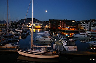
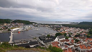
is a town and the administrative centre of the municipality of Kinn which is in Vestland county, Norway. The town was founded by royal decree in 1860 as a ladested on the island of Florelandet, located between the Botnafjorden and Solheimsfjorden. Florø is Norway's westernmost town. It is the most western town on the mainland in the Nordic countries.

Brevik is a town in Porsgrunn Municipality in Telemark county, Norway. The town is located where the Eidangerfjorden and Frierfjorden join together to form the Breviksfjorden. Brevik is regarded as one of the best preserved towns from the sailing ship era. The town is located on the far end of Eidanger peninsula, and was a former export centre for ice and timber. The last shipment of wood to the United Kingdom was around 1960.

Davik is a former municipality in the traditional district of Nordfjord in the old Sogn og Fjordane county, Norway. The 654-square-kilometre (253 sq mi) former municipality existed from 1838 until 1964 and it encompassed all the lands surrounding the outer part of the large Nordfjorden on both sides of the fjord. Davik was located in parts of the present-day municipalities of Kinn, Bremanger, and Stad. The administrative center of the former municipality was the village of Davik which is located on the southern shore of the Nordfjorden, although some of the municipal services were based out of the village of Bryggja on the north side of the fjord, since that village was the largest village in Davik municipality.
Skudenes is a former municipality in Rogaland county, Norway. It was part of the traditional district of Haugaland. The 68-square-kilometre (26 sq mi) municipality existed from 1838 until its dissolution in 1965. The administrative centre was the town of Skudeneshavn. The municipality originally encompassed land that is now part of the municipalities of Bokn and Karmøy. It included the southern part of the island of Karmøy and the three islands to the east: Vestre Bokn, Austre Bokn, and Ognøya. In 1849, the three smaller islands were separated to form Bokn municipality.
Vestre Moland is a former municipality in the old Aust-Agder county in Norway. The administrative centre of the municipality was the village of Møglestu where the Vestre Moland Church is located. The 103-square-kilometre (40 sq mi) municipality existed from 1838 until 1962 when it was merged into the municipality of Lillesand. Today, the area of Vestre Moland covers the northern part of the present-day municipality of Lillesand in Agder county.
Nord-Vågsøy is a former municipality in the old Sogn og Fjordane county, Norway. The municipality existed from 1910 until 1964, and it encompassed the northern part of the island of Vågsøy. The area of Nord-Vågsøy now makes up the northern part of the present-day Kinn Municipality in Vestland county. The administrative centre was the village of Raudeberg where the Nord-Vågsøy Church is located. Other villages in Nord-Vågsøy include Halsør, Vedvik, Refvik, Kvalheim, and Kråkenes.

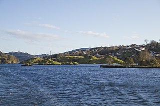
Bru is a former municipality in the old Sogn og Fjordane county, Norway. The 382-square-kilometre (147 sq mi) municipality existed from 1923 until 1964 and it included several islands including Svanøya, Askrova, and Stavøya as well as parts of the mainland including the Solheimsdalen valley, east of the village of Norddalsfjord. It is now part of the present-day Kinn Municipality which is in Vestland county in the traditional district of Sunnfjord. The administrative center of Bru was the village of Stavang.

Hosanger is a former municipality in the old Hordaland county, Norway. The municipality existed from 1838 until its dissolution in 1964. The municipality was located in what is now parts of Alver Municipality and Osterøy Municipality in Vestland county. It originally covered all the lands on both sides of the Osterfjorden-Romarheimsfjorden from the Lonevågen fjord all the way east to the county border at the end of the Modalen valley. Hosanger also included an exclave on the Lindås peninsula surrounding the village of Seim at the southern end of the Lurefjorden. Seim was separated from the rest of Hosanger by part of Lindås Municipality. Over time, the areas of Seim and Modalen were split off from Hosanger. The administrative centre of the municipality was the village of Hosanger on the island of Osterøy, where Hosanger Church is located.

Vevring is a former municipality in the old Sogn og Fjordane county, Norway. The municipality existed from 1838 until its dissolution in 1964. It encompassed the land surrounding the western part of the Førdefjorden on both the north and south shores of the fjord in what is now Kinn, Askvoll, and Sunnfjord municipalities in Vestland county. It stretched from the Ålasundet strait in the east to the mouth of the fjord in the west and from the Steindalen valley in the north to the mountains south of the fjord. The municipality was 120 square kilometres (46 sq mi) in 1964 when it was dissolved.

Sogndal is a former municipality and small seaport (ladested) in Rogaland county, Norway. The municipality is located on the coast in the traditional district of Dalane. The 19-hectare (47-acre) municipality existed from 1845 until its dissolution in 1944 when it was merged into the municipality of Sokndal. It comprised the two harbor villages: the 7-hectare (17-acre) Sogndalsstranda and the 12-hectare (30-acre) Rægefjord. The river Sogndalselva reaches the ocean at Songdalsstranda.
Torvastad is a former municipality in Rogaland county, Norway. The municipality existed from 1838 until 1965. The administrative centre was the village of Haugesund, and after that it was the village of Torvastad on the island of Karmøy. Today, the area of Torvastad refers to the northern part of the municipality of Karmøy.

Eikefjord is a former municipality in the Sunnfjord district in the old Sogn og Fjordane county, Norway. The 145-square-kilometre (56 sq mi) municipality existed from 1923 until 1964 when it joined Flora Municipality. The administrative center of the former municipality was the village of Eikefjord, where Eikefjord Church is located. The municipality of Eikefjord was located at the end of the Eikefjorden, about 30 kilometres (19 mi) east of the town of Florø. The lake Endestadvatnet was part of the municipality. The municipality encompassed the immediate area around the village of Eikefjord and to the east and south of the village.
Høyland is a former municipality in Rogaland county, Norway. The 170-square-kilometre (66 sq mi) municipality was located at the innermost end of the Gandsfjorden in the western part of the present-day municipality of Sandnes. The municipality existed from 1838 until its dissolution in 1965. The main church for the municipality was Høyland Church.
Alversund is a former municipality in the old Hordaland county, Norway. The municipality existed from 1885 until 1964. It was located in the southwestern part of the mainland portion of the present-day Alver Municipality in Vestland county. It originally included area on the island of Holsnøy as well, but that was later separated. Alversund covered 59 square kilometres (23 sq mi) upon its dissolution in 1964. The administrative centre of the municipality was the village of Alversund, where Alversund Church is located.
Mandal is a town in Lindesnes municipality in Agder county, Norway. Mandal is the fourth largest town in Agder as well as the administrative centre of Lindesnes municipality. It is located at the mouth of the river Mandalselva at the southern end of the Mandalen valley. The 6.63-square-kilometre (1,640-acre) town has a population (2019) of 11,053 and a population density of 1,667 inhabitants per square kilometre (4,320/sq mi). In Norway, Mandal is considered a by which can be translated as either a "town" or "city" in English.

Vemundvik is a former municipality in the old Nord-Trøndelag county, Norway. The 247-square-kilometre (95 sq mi) municipality existed from 1838 until its dissolution in 1964. By 1964, the municipality roughly corresponded to the mainland areas north of the river Namsen in what is now the municipality of Namsos in Trøndelag county. From 1838 until about 1942, the administrative centre was the village of Vemundvik where Vemundvik Church is located. After 1941, the municipal offices and administration was headquartered in the town of Namsos.
Kinn is a municipality in Vestland county, Norway. It was established on 1 January 2020. It is in the traditional districts of Nordfjord and Sunnfjord. The municipality is the only non-contiguous municipality in Norway since the municipality of Bremanger lies in between the north and south parts of Kinn. The administrative centres of the municipality is the two cities of Florø and Måløy. Some villages in the municipality include Rognaldsvåg, Stavang, Grov, Norddalsfjord, Nyttingnes, Steinhovden, Brandsøy, Deknepollen, Holvika, Kvalheim, Langeneset, Raudeberg, Refvika, Silda, Tennebø, Vedvika, and Vågsvåg.