Fjaler

Last updated
Fjaler Municipality
Fjaler kommune
Ytre Holmedal herred  (historic name)
Dalsfjorden Rivedal.jpg
View of Fjaler to the left of the fjord
Norway Counties Vestland Position.svg
Vestland within Norway
NO 4646 Fjaler.svg
Fjaler within Vestland
Coordinates: 61°18′22″N05°27′48″E / 61.30611°N 5.46333°E / 61.30611; 5.46333
Country Norway
County Vestland
District Sunnfjord
Established1 Jan 1838
  Created as Formannskapsdistrikt
Administrative centre Dale i Sunnfjord
Government
  Mayor (2023)Leif Jarle Espedal (Ap)
Area
  Total416.60 km2 (160.85 sq mi)
  Land390.09 km2 (150.61 sq mi)
  Water26.50 km2 (10.23 sq mi)  6.4%
  Rank#234 in Norway
Population
 (2023)
  Total2,913
  Rank#231 in Norway
  Density7.5/km2 (19/sq mi)
  Change (10 years)
Increase2.svg +1.5%
Demonyms Dalsfjording
Fjalerbu [1]
Official language
[2]
   Norwegian form Nynorsk
Time zone UTC+01:00 (CET)
  Summer (DST) UTC+02:00 (CEST)
ISO 3166 code NO-4646 [3]
Website Official website

Fjaler is a municipality in the county of Vestland, Norway. It is located in the traditional district of Sunnfjord. The administrative centre is the village of Dale. Other places in Fjaler include Espedal, Flekke, Folkestad, Guddal, and Hellevika.

Contents

Fjaler was the birthplace of famous Norwegian poet Jakob Sande. The UWC Red Cross Nordic at Haugland, one of the eighteen United World Colleges of the world is also located here, as well as the Nordic Art Centre at Dalsåsen. There is a bridge connecting Dale to Eikenes in Askvoll municipality, and buses depart from Dale to Førde, Rysjedalsvika, Hyllestad, and the western part of Fjaler. Førde Airport, Bringeland is located about 28 kilometres (17 mi) to the east, with flights to Oslo and Bergen.

The 417-square-kilometre (161 sq mi) municipality is the 234th largest by area out of the 356 municipalities in Norway. Fjaler is the 231st most populous municipality in Norway with a population of 2,913. The municipality's population density is 7.5 inhabitants per square kilometre (19/sq mi) and its population has increased by 1.5% over the previous 10-year period. [4] [5]

General information

Dale Church Dale kyrkjestad.jpg
Dale Church

Ytre Holmedal was established as a municipality on 1 January 1838 (see formannskapsdistrikt law). The original municipality was identical to the Ytre Holmedal parish (prestegjeld) with the sub-parishes (sokn) of Holmedal, Dale, and Fjaler. In 1912, the name Ytre Holmedal was changed to Fjaler. [6]

On 1 January 1990, some changes were made to the boundaries between the municipalities of Fjaler, Gaular, and Askvoll. The areas surrounding the villages of Fure, Folkestad, and Våge (population: 482) in Askvoll were transferred to Fjaler municipality. The areas surrounding the villages of Vårdal, Holmedal, Rivedal, and a part of Hestad (population: 731) in Fjaler were transferred to Askvoll municipality. The parts of Hestad that did not go to Askvoll (population: 90) were transferred to Gaular municipality. [7]

On 1 January 2020, the municipality became part of the newly created Vestland county after Sogn og Fjordane and Hordaland counties were merged.

Name

The municipality (originally the parish) was named Ytre Holmedal, after the old Holmedal farm (Old Norse : Hǫlmudalr) since the first Holmedal Church was built there. The meaning of the first element of Holmedal is uncertain, but it may have been an old name for a local river, Holma. It is unknown what the river name meant. The last element is dalr which means "valley" or "dale". The prefix ytre (which means "outer") was added to distinguish the area from its neighbor, Indre Holmedal. [8]

On 6 December 1912, a royal resolution changed the spelling of the name of the municipality to Fjaler. [9] This new name brought back a very old name for the area (Old Norse : Fjalir). The name was the ancient name for the fjord (now called the Dalsfjorden). The name comes from the plural form of the word fjǫl which means "board" or "table". Older forms of the name were Fjalir or Fjalar. [10] [11]

Coat of arms

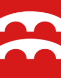
The coat of arms was granted on 8 February 1991. The official blazon is "Gules, two arched bridges argent" (Norwegian : På raud grunn to sølv kvelvingsbruer). This means the arms have a red field (background) and the charge is two arched stone bridges. The charge has a tincture of argent which means it is commonly colored white, but if it is made out of metal, then silver is used. The two bridges symbolize the old, historic bridges in the municipality that are part of the old post road that goes through Fjaler on its way to Trondheim. The arms were designed by Inge Rotevatn from Nordfjord. The municipal flag has the same design as the coat of arms. [12] [13] [14]

Churches

The Church of Norway has one parish (sokn) within the municipality of Fjaler. It is part of the Sunnfjord prosti (deanery) in the Diocese of Bjørgvin.

Churches in Fjaler
Parish (sokn)Church nameLocation of the churchYear built
Fjaler Dale Church Dale 1864
Folkestad Chapel Våge1913
Guddal Church Guddal 1870
Hellevik Chapel Hellevika 1978

Government

Fjaler Municipality is responsible for primary education (through 10th grade), outpatient health services, senior citizen services, welfare and other social services, zoning, economic development, and municipal roads and utilities. The municipality is governed by a municipal council of directly elected representatives. The mayor is indirectly elected by a vote of the municipal council. [15] The municipality is under the jurisdiction of the Sogn og Fjordane District Court and the Gulating Court of Appeal.

Municipal council

The municipal council (Kommunestyre) of Fjaler is made up of 23 representatives that are elected to four year terms. The tables below show the current and historical composition of the council by political party.

Fjaler kommunestyre 20232027 [16]   
Party name (in Nynorsk)Number of
representatives
  Labour Party (Arbeidarpartiet)5
  Green Party (Miljøpartiet Dei Grøne)2
  Conservative Party (Høgre)4
  Centre Party (Senterpartiet)6
  Socialist Left Party (Sosialistisk Venstreparti)2
  Liberal Party (Venstre)4
Total number of members:23
Fjaler kommunestyre 20192023 [17]   
Party name (in Nynorsk)Number of
representatives
  Labour Party (Arbeidarpartiet)4
  Progress Party (Framstegspartiet)1
  Green Party (Miljøpartiet Dei Grøne)2
  Conservative Party (Høgre)2
  Centre Party (Senterpartiet)7
  Socialist Left Party (Sosialistisk Venstreparti)2
  Liberal Party (Venstre)5
Total number of members:23
Fjaler kommunestyre 20152019 [18]   
Party name (in Nynorsk)Number of
representatives
  Labour Party (Arbeidarpartiet)7
  Green Party (Miljøpartiet Dei Grøne)1
  Conservative Party (Høgre)2
  Christian Democratic Party (Kristeleg Folkeparti)1
  Centre Party (Senterpartiet)8
  Socialist Left Party (Sosialistisk Venstreparti)1
  Liberal Party (Venstre)3
Total number of members:23
Fjaler kommunestyre 20112015 [19]   
Party name (in Nynorsk)Number of
representatives
  Labour Party (Arbeidarpartiet)11
  Conservative Party (Høgre)3
  Christian Democratic Party (Kristeleg Folkeparti)1
  Centre Party (Senterpartiet)4
  Socialist Left Party (Sosialistisk Venstreparti)1
  Liberal Party (Venstre)3
Total number of members:23
Fjaler kommunestyre 20072011 [18]   
Party name (in Nynorsk)Number of
representatives
  Labour Party (Arbeidarpartiet)11
  Progress Party (Framstegspartiet)2
  Conservative Party (Høgre)3
  Christian Democratic Party (Kristeleg Folkeparti)2
  Centre Party (Senterpartiet)3
  Socialist Left Party (Sosialistisk Venstreparti)1
  Liberal Party (Venstre)1
Total number of members:23
Fjaler kommunestyre 20032007 [18]   
Party name (in Nynorsk)Number of
representatives
  Labour Party (Arbeidarpartiet)6
  Conservative Party (Høgre)4
  Christian Democratic Party (Kristeleg Folkeparti)1
  Centre Party (Senterpartiet)5
  Socialist Left Party (Sosialistisk Venstreparti)3
  Liberal Party (Venstre)4
Total number of members:23
Fjaler kommunestyre 19992003 [18]   
Party name (in Nynorsk)Number of
representatives
  Labour Party (Arbeidarpartiet)7
  Conservative Party (Høgre)5
  Christian Democratic Party (Kristeleg Folkeparti)2
  Centre Party (Senterpartiet)6
  Socialist Left Party (Sosialistisk Venstreparti)1
  Liberal Party (Venstre)2
Total number of members:23
Fjaler kommunestyre 19951999 [20]   
Party name (in Nynorsk)Number of
representatives
  Labour Party (Arbeidarpartiet)7
  Conservative Party (Høgre)4
  Christian Democratic Party (Kristeleg Folkeparti)1
  Centre Party (Senterpartiet)7
  Socialist Left Party (Sosialistisk Venstreparti)2
  Liberal Party (Venstre)2
Total number of members:23
Fjaler kommunestyre 19911995 [21]   
Party name (in Nynorsk)Number of
representatives
  Labour Party (Arbeidarpartiet)8
  Conservative Party (Høgre)3
  Christian Democratic Party (Kristeleg Folkeparti)2
  Centre Party (Senterpartiet)11
  Socialist Left Party (Sosialistisk Venstreparti)3
  Liberal Party (Venstre)2
Total number of members:29
Fjaler kommunestyre 19871991 [22]   
Party name (in Nynorsk)Number of
representatives
  Labour Party (Arbeidarpartiet)10
  Conservative Party (Høgre)5
  Christian Democratic Party (Kristeleg Folkeparti)2
  Centre Party (Senterpartiet)7
  Socialist Left Party (Sosialistisk Venstreparti)3
  Liberal Party (Venstre)2
Total number of members:29
Fjaler kommunestyre 19831987 [23]   
Party name (in Nynorsk)Number of
representatives
  Labour Party (Arbeidarpartiet)12
  Conservative Party (Høgre)4
  Christian Democratic Party (Kristeleg Folkeparti)3
  Centre Party (Senterpartiet)7
  Socialist Left Party (Sosialistisk Venstreparti)1
  Liberal Party (Venstre)2
Total number of members:29
Fjaler kommunestyre 19791983 [24]   
Party name (in Nynorsk)Number of
representatives
  Labour Party (Arbeidarpartiet)9
  Conservative Party (Høgre)4
  Christian Democratic Party (Kristeleg Folkeparti)3
  Centre Party (Senterpartiet)9
  Socialist Left Party (Sosialistisk Venstreparti)1
  Liberal Party (Venstre)1
  Local list for the school district Rivedal-Holmedal-Vårdal
(Bygdeliste for skulekrinsane Rivedal-Holmedal-Vårdal)
2
Total number of members:29
Fjaler kommunestyre 19751979 [25]   
Party name (in Nynorsk)Number of
representatives
  Labour Party (Arbeidarpartiet)10
  Conservative Party (Høgre)2
  Christian Democratic Party (Kristeleg Folkeparti)4
  New People's Party (Nye Folkepartiet)1
  Centre Party (Senterpartiet)10
  Socialist Left Party (Sosialistisk Venstreparti)1
  Liberal Party (Venstre)1
Total number of members:29
Fjaler kommunestyre 19711975 [26]   
Party name (in Nynorsk)Number of
representatives
  Labour Party (Arbeidarpartiet)10
  Christian Democratic Party (Kristeleg Folkeparti)3
  Centre Party (Senterpartiet)9
  Socialist People's Party (Sosialistisk Folkeparti)1
  Liberal Party (Venstre)4
  Joint List(s) of Non-Socialist Parties (Borgarlege Felleslister)2
Total number of members:29
Fjaler kommunestyre 19671971 [27]   
Party name (in Nynorsk)Number of
representatives
  Labour Party (Arbeidarpartiet)11
  Christian Democratic Party (Kristeleg Folkeparti)3
  Centre Party (Senterpartiet)9
  Socialist People's Party (Sosialistisk Folkeparti)1
  Liberal Party (Venstre)5
Total number of members:29
Fjaler kommunestyre 19631967 [28]   
Party name (in Nynorsk)Number of
representatives
  Labour Party (Arbeidarpartiet)10
  Christian Democratic Party (Kristeleg Folkeparti)3
  Centre Party (Senterpartiet)9
  Liberal Party (Venstre)7
Total number of members:29
Fjaler heradsstyre 19591963 [29]   
Party name (in Nynorsk)Number of
representatives
  Labour Party (Arbeidarpartiet)9
  Centre Party (Senterpartiet)10
  Liberal Party (Venstre)7
  Local List(s) (Lokale lister)3
Total number of members:29
Fjaler heradsstyre 19551959 [30]   
Party name (in Nynorsk)Number of
representatives
  Labour Party (Arbeidarpartiet)10
  Farmers' Party (Bondepartiet)6
  Liberal Party (Venstre)6
  Local List(s) (Lokale lister)7
Total number of members:29
Fjaler heradsstyre 19511955 [31]   
Party name (in Nynorsk)Number of
representatives
  Labour Party (Arbeidarpartiet)11
  Farmers' Party (Bondepartiet)8
  Liberal Party (Venstre)8
  Local List(s) (Lokale lister)9
Total number of members:36
Fjaler heradsstyre 19471951 [32]   
Party name (in Nynorsk)Number of
representatives
  Labour Party (Arbeidarpartiet)12
  Farmers' Party (Bondepartiet)3
  Liberal Party (Venstre)6
  Joint List(s) of Non-Socialist Parties (Borgarlege Felleslister)8
  Local List(s) (Lokale lister)7
Total number of members:36
Fjaler heradsstyre 19451947 [33]   
Party name (in Nynorsk)Number of
representatives
  Labour Party (Arbeidarpartiet)11
  Joint List(s) of Non-Socialist Parties (Borgarlege Felleslister)11
  Local List(s) (Lokale lister)14
Total number of members:36
Fjaler heradsstyre 19371941* [34]   
Party name (in Nynorsk)Number of
representatives
  Labour Party (Arbeidarpartiet)9
  Farmers' Party (Bondepartiet)3
  Liberal Party (Venstre)6
  Joint List(s) of Non-Socialist Parties (Borgarlege Felleslister)9
  Local List(s) (Lokale lister)9
Total number of members:36
Note: Due to the German occupation of Norway during World War II, no elections were held for new municipal councils until after the war ended in 1945.

Mayors

The mayors (Nynorsk : ordførar) of Fjaler: [35]

  • 1838–1847: Johan Widing Heiberg Landmark
  • 1847–1847: Bertel Vonen
  • 1847–1855: Peder J. Fossedal
  • 1855–1860: P. J. Smith
  • 1860–1862: Ola Mathiasson Bakke
  • 1863–1868: Peder C. Mork
  • 1868–1868: J. Vonen
  • 1868–1872: J. Kalstad
  • 1872–1876: Mons Davidson Huustvedt
  • 1876–1880: P. J. Smith
  • 1880–1892: L. Larsen
  • 1892–1896: Mons Davidson Huustvedt
  • 1896–1898: David Olsen Bakke
  • 1899–1904: Ole A. Skarstein
  • 1904–1910: David Olsen Bakke
  • 1911–1913: Øystein Sørebø
  • 1914–1916: Andreas Sande
  • 1917–1919: Ola J. Espedal
  • 1920–1928: Andreas Sande
  • 1929–1934: Knut Bakkelid
  • 1935–1940: Ragnvald Fagerheim
  • 1941–1942: Søren K. Hauge
  • 1945–1945: David M. Hustveit
  • 1945–1947: Ragnvald Fagerheim
  • 1948–1959: Søren K. Hauge
  • 1960–1961: Jonas Mork
  • 1961–1963: Aksel Hovland (V)
  • 1964–1965: Gustav Stavøstrand (V)
  • 1966–1967: Ola Sørebø (V)
  • 1968–1971: Andreas Sande (Sp)
  • 1972–1975: Arne Barnsnes (Ap)
  • 1976–1981: Trygve Bjånes (Ap)
  • 1982–1987: Kåre Kleppe (Sp)
  • 1988–1989: Magnar Vagstad (Ap)
  • 1990–1995: Rasmus Felde (Sp)
  • 1995–2002: Arne Kyrkjebø (Ap)
  • 2002–2003: Jan Ulltang (Sp)
  • 2003–2015: Arve Helle (Ap)
  • 2015–2019: Gunhild Berge Stang (V)
  • 2019-2023: Kjetil Høgseth Felde (Sp)
  • 2023-present: Leif Jarle Espedal (Ap) [36]

Geography

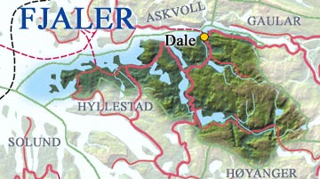
Fjaler municipality lies to the south of the Dalsfjord in the Sunnfjord region. The municipality of Askvoll lies to the north (across the fjord), the municipality of Sunnfjord lies to the northeast, the municipality of Høyanger lies to the southeast, and the municipalities of Hyllestad and Solund lie to the southwest.

Jakob Sande, 1929 Jakob Sande.jpg
Jakob Sande, 1929

Notable people

Related Research Articles

<span class="mw-page-title-main">Masfjorden</span> Municipality in Vestland, Norway

Masfjorden is a municipality in the central part of Vestland county in Norway. The municipality is located in the Nordhordland district of the county. The administrative centre of the municipality is the village of Masfjordnes. Other villages in the municipality include Frøyset, Hosteland, Matre, and Solheim.

<span class="mw-page-title-main">Sande, Møre og Romsdal</span> Municipality in Møre og Romsdal, Norway

Sande is a municipality in Møre og Romsdal county, Norway. It is part of the Sunnmøre region. The administrative centre is the village of Larsnes on the island of Gurskøya. Other villages in Sande include Gursken, Sandshamn, Bringsinghaug, and Voksa.

<span class="mw-page-title-main">Ørsta</span> Municipality in Møre og Romsdal, Norway

is a municipality in Møre og Romsdal county, Norway. It is part of the Sunnmøre region of Western Norway. The administrative centre of the municipality is the village of Ørsta. Other villages in the municipality include Hovdebygda, Flåskjer, Liadal, Urke, Barstadvik, Åmdalen, Follestaddalen, Nordre Vartdal, Vartdal, Sæbø, Sætre, Store-Standal, and Ytre Standal.

<span class="mw-page-title-main">Gulen</span> Municipality in Vestland, Norway

is a municipality in the western part of Vestland county, Norway. It is part of the traditional district of Sogn. The administrative center of the municipality is the village of Eivindvik. Other villages in Gulen include Brekke, Byrknes, Dalsøyra, Dingja, Instefjord, Mjømna, Rutledal, and Ytre Oppedal.

<span class="mw-page-title-main">Solund</span> Municipality in Vestland, Norway

Solund is a municipality in the county of Vestland, Norway. It is located in the traditional district of Sogn. Solund is the westernmost island municipality in Norway. Holmebåen on the island of Steinsøy is the westernmost point in all of Norway. Most residents of Solund live on the main islands of Sula and Ytre Sula. The administrative centre of Solund is the village of Hardbakke on Sula island. Some other villages in Solund include Kolgrov on Ytre Sula, Hersvikbygda on Sula, and Losnegard on Losna.

<span class="mw-page-title-main">Hyllestad</span> Municipality in Vestland, Norway

Hyllestad is a municipality in the county of Vestland, Norway. It is located in the traditional district of Sogn. The administrative center is the village of Hyllestad. Other villages in the municipality include Sørbøvågen and Leirvik. Hyllestad municipality has existed since 1862 when it was created from parts of the neighboring municipalities of Askvoll and Lavik. Hyllestad is located on the north side of the Sognefjorden, near the mouth of the fjord.

<span class="mw-page-title-main">Høyanger</span> Municipality in Vestland, Norway

Høyanger is a municipality in Vestland county, Norway. It is located in the traditional district of Sogn. The administrative center is the village of Høyanger. Other villages in Høyanger municipality include Austreim, Bjordal, Kyrkjebø, Lavik, Ortnevik, and Vadheim.

<span class="mw-page-title-main">Leikanger</span> Former municipality in Sogn og Fjordane, Norway

Leikanger is a former municipality in Sogn og Fjordane county, Norway. It was located on the northern shore of the Sognefjorden in the traditional district of Sogn. The administrative center was the village of Hermansverk, which also was the administrative center of the old Sogn og Fjordane county.

<span class="mw-page-title-main">Luster, Norway</span> Municipality in Vestland, Norway

Luster is a municipality in Vestland county, Norway. It is located at the end of the Sognefjorden in the traditional district of Sogn. The administrative centre is the village of Gaupne. Other villages in Luster include Fortun, Hafslo, Indre Hafslo, Jostedal, Luster, Nes, Ornes, Skjolden, Solvorn, and Veitastrond.

<span class="mw-page-title-main">Askvoll</span> Municipality in Vestland, Norway

is a municipality in Vestland county, Norway. It is located in the traditional district of Sunnfjord. The administrative centre is the village of Askvoll. Other villages in the municipality include Holmedal, Kvammen, and Stongfjorden. The most important industries in Askvoll today are Helle Knivfabrikk, Bulandet Fiskeindustri, and Sigurd Løkeland Hermetikkfabrikk.

<span class="mw-page-title-main">Gaular</span> Former municipality in Sogn og Fjordane county, Norway

Gaular is a former municipality in Sogn og Fjordane county, Norway. It was located in the traditional district of Sunnfjord. The administrative centre was the village of Sande. Other villages in the municipality included Bygstad, Hestad, and Vik. Gaular was sometimes referred to as Fosselandet because it was home to 28 large and small waterfalls. The municipality was centered on the river Gaula. The Viksdalen valley was located in Gaular.

<span class="mw-page-title-main">Jølster</span> Former municipality in Sogn og Fjordane, Norway

Jølster is a former municipality in Sogn og Fjordane county, Norway. It was located in the traditional district of Sunnfjord. The administrative centre was the village of Skei. Other villages in the municipality included Helgheim, Ålhus, Vassenden, and Langhaugane.

<span class="mw-page-title-main">Førde</span> Former municipality in Sogn og Fjordane county, Norway

Førde is a former municipality in the county of Sogn og Fjordane, Norway. It was located in the traditional district of Sunnfjord. The administrative center was the town of Førde which in 2016 had 10,255 inhabitants. Other villages in Førde municipality included Bruland, Holsen, Moskog, and Haukedalen. The Øyrane area in the town of Førde was a large industrial/commercial area for the region. The European Route E39 highway passed through the municipality, and it passed by the lake Holsavatnet.

<span class="mw-page-title-main">Naustdal</span> Former municipality in Sogn og Fjordane, Norway

Naustdal is a former municipality in the old Sogn og Fjordane county, Norway. It was located in the traditional district of Sunnfjord. The administrative centre was the village of Naustdal, which has 1,188 inhabitants (2017). Other villages in Naustdal include Indrevevring and Helle. The municipality became part of Sunnfjord Municipality in Vestland county on 1 January 2020.

<span class="mw-page-title-main">Bremanger</span> Municipality in Vestland, Norway

Bremanger is a municipality in Vestland county, Norway. The village of Svelgen is the administrative centre of the municipality. Other villages include Bremanger, Berle, Davik, Isane, Kalvåg, Svelgen, Rugsund, and Ålfoten. Bremanger is the only municipality in Vestland, which is located in two districts. The northern and eastern parts comprising the villages of Oldeide, Berle, Rugsund, Davik, Isane, and Ålfoten is located in the Nordfjord region, while the villages of Bremanger, Kalvåg, Svelgen, Sørgulen, and Botnane are located in the Sunnfjord region. Politically, the municipality works with the Nordfjord region in the council of Nordfjord municipalities.

<span class="mw-page-title-main">Selje</span> Former municipality in Sogn og Fjordane, Norway

Selje is a former municipality in the old Sogn og Fjordane county, Norway and was located in the traditional district of Nordfjord. The village of Selje was the administrative center this municipality. Other villages and neighborhoods in the municipality included Barmen, Ervik, Flatraket, Hoddevik, Hoddevika, Håvik, and Leikanger. On 1 January 2020 the municipality became part of the new Stad Municipality in the newly formed Vestland county.

<span class="mw-page-title-main">Hornindal</span> Former municipality in Sogn og Fjordane county, Norway

Hornindal is a former municipality in the old Sogn og Fjordane county, Norway. It existed from 1867 until 1965 and then again from 1977 until 2020. It was located in the traditional district of Nordfjord. The administrative centre of the municipality was the village of Grodås. The municipality was located at the eastern end of the lake Hornindalsvatnet, the deepest lake in Northern Europe. The rest of the lake lies inside neighboring Eid Municipality.

<span class="mw-page-title-main">Stryn</span> Municipality in Vestland, Norway

Stryn is a municipality in the county of Vestland, Norway. It is located in the traditional district of Nordfjord. The administrative center of the municipality is the village of Stryn. The municipality is located along the innermost part of the Nordfjorden. Some of the main villages in Stryn include Loen, Innvik, Utvik, Randabygda, Olden, and Flo.

<span class="mw-page-title-main">Bru, Sogn og Fjordane</span> Former municipality in Sogn og Fjordane, Norway

Bru is a former municipality in the old Sogn og Fjordane county, Norway. The 382-square-kilometre (147 sq mi) municipality existed from 1923 until 1964 and it included several islands including Svanøya, Askrova, and Stavøya as well as parts of the mainland including the Solheimsdalen valley, east of the village of Norddalsfjord. It is now part of the present-day Kinn Municipality which is in Vestland county in the traditional district of Sunnfjord. The administrative center of Bru was the village of Stavang.

<span class="mw-page-title-main">Vevring</span> Former municipality in Sogn og Fjordane, Norway

Vevring is a former municipality in the old Sogn og Fjordane county, Norway. The municipality existed from 1838 until its dissolution in 1964. It encompassed the land surrounding the western part of the Førdefjorden on both the north and south shores of the fjord in what is now Kinn, Askvoll, and Sunnfjord municipalities in Vestland county. It stretched from the Ålasundet strait in the east to the mouth of the fjord in the west and from the Steindalen valley in the north to the mountains south of the fjord. The municipality was 120 square kilometres (46 sq mi) in 1964 when it was dissolved.

References

  1. "Navn på steder og personer: Innbyggjarnamn" (in Norwegian). Språkrådet.
  2. "Forskrift om målvedtak i kommunar og fylkeskommunar" (in Norwegian). Lovdata.no.
  3. Bolstad, Erik; Thorsnæs, Geir, eds. (26 January 2023). "Kommunenummer". Store norske leksikon (in Norwegian). Kunnskapsforlaget.
  4. Statistisk sentralbyrå. "Table: 06913: Population 1 January and population changes during the calendar year (M)" (in Norwegian).
  5. Statistisk sentralbyrå. "09280: Area of land and fresh water (km²) (M)" (in Norwegian).
  6. Natvik, Oddvar (9 February 2005). "Some historical data on the 26 Kommunes". Archived from the original on 24 July 2011.
  7. Jukvam, Dag (1999). "Historisk oversikt over endringer i kommune- og fylkesinndelingen" (PDF) (in Norwegian). Statistics Norway.
  8. Rygh, Oluf (1919). Norske gaardnavne: Nordre Bergenhus amt (in Norwegian) (12 ed.). Kristiania, Norge: W. C. Fabritius & sønners bogtrikkeri. pp. 263–264.
  9. "Norsk Lovtidende. 2den Afdeling. 1912. Samling af Love, Resolutioner m.m". Norsk Lovtidend (in Norwegian). Oslo, Norway: Grøndahl og Søns Boktrykkeri: 586. 1912.
  10. "F — A Concise Dictionary of Old Icelandic — Словари — Северная Слава".
  11. Rygh, Oluf (1919). Norske gaardnavne: Nordre Bergenhus amt (in Norwegian) (12 ed.). Kristiania, Norge: W. C. Fabritius & sønners bogtrikkeri. pp. 284–285.
  12. "Civic heraldry of Norway - Norske Kommunevåpen". Heraldry of the World. Retrieved 13 May 2023.
  13. "Fjaler, Sogn og Fjordane (Norway)". Flags of the World. Retrieved 13 May 2023.
  14. "Godkjenning av våpen og flagg". Lovdata.no (in Norwegian). Norges kommunal- og arbeidsdepartementet. 15 April 1991. Retrieved 13 May 2023.
  15. Hansen, Tore; Vabo, Signy Irene, eds. (20 September 2022). "kommunestyre". Store norske leksikon (in Norwegian). Kunnskapsforlaget . Retrieved 14 October 2022.
  16. "Kommunestyrevalg 2023 - Vestland". Valgdirektoratet . Retrieved 21 January 2024.
  17. "Kommunestyrevalg 2019 – Vestland". Valgdirektoratet . Retrieved 29 October 2019.
  18. 1 2 3 4 "Table: 04813: Members of the local councils, by party/electoral list at the Municipal Council election (M)" (in Norwegian). Statistics Norway.
  19. "Kommunestyrevalg 2011 – Sogn og Fjordane". Valgdirektoratet . Retrieved 29 October 2019.
  20. "Kommunestyrevalget 1995" (PDF) (in Norwegian). Oslo-Kongsvinger: Statistisk sentralbyrå. 1996. Retrieved 18 February 2020.
  21. "Kommunestyrevalget 1991" (PDF) (in Norwegian). Oslo-Kongsvinger: Statistisk sentralbyrå. 1993. Retrieved 18 February 2020.
  22. "Kommunestyrevalget 1987" (PDF) (in Norwegian). Oslo-Kongsvinger: Statistisk sentralbyrå. 1988. Retrieved 18 February 2020.
  23. "Kommunestyrevalget 1983" (PDF) (in Norwegian). Oslo-Kongsvinger: Statistisk sentralbyrå. 1984. Retrieved 18 February 2020.
  24. "Kommunestyrevalget 1979" (PDF) (in Norwegian). Oslo: Statistisk sentralbyrå. 1979. Retrieved 18 February 2020.
  25. "Kommunevalgene 1975" (PDF) (in Norwegian). Oslo: Statistisk sentralbyrå. 1977. Retrieved 1 May 2020.
  26. "Kommunevalgene 1972" (PDF) (in Norwegian). Oslo: Statistisk sentralbyrå. 1973. Retrieved 1 May 2020.
  27. "Kommunevalgene 1967" (PDF) (in Norwegian). Oslo: Statistisk sentralbyrå. 1967. Retrieved 1 May 2020.
  28. "Kommunevalgene 1963" (PDF) (in Norwegian). Oslo: Statistisk sentralbyrå. 1964. Retrieved 1 May 2020.
  29. "Kommunevalgene og Ordførervalgene 1959" (PDF) (in Norwegian). Oslo: Statistisk sentralbyrå. 1960. Retrieved 1 May 2020.
  30. "Kommunevalgene og Ordførervalgene 1955" (PDF) (in Norwegian). Oslo: Statistisk sentralbyrå. 1957. Retrieved 1 May 2020.
  31. "Kommunevalgene og Ordførervalgene 1951" (PDF) (in Norwegian). Oslo: Statistisk sentralbyrå. 1952. Retrieved 1 May 2020.
  32. "Kommunevalgene og Ordførervalgene 1947" (PDF) (in Norwegian). Oslo: Statistisk sentralbyrå. 1948. Retrieved 1 May 2020.
  33. "Kommunevalgene og Ordførervalgene 1945" (PDF) (in Norwegian). Oslo: Statistisk sentralbyrå. 1947. Retrieved 1 May 2020.
  34. "Kommunevalgene og Ordførervalgene 1937" (PDF) (in Norwegian). Oslo: Statistisk sentralbyrå. 1938. Retrieved 1 May 2020.
  35. "Ordførarar i Fjaler". NRK Fylkesleksikon (in Norwegian Nynorsk). Retrieved 14 May 2023.
  36. "Espedal blir ordførar i Fjaler". NRK (in Norwegian). 14 September 2023. Retrieved 20 January 2024.