
Masfjorden is a municipality in the central part of Vestland county in Norway. The municipality is located in the Nordhordland district of the county. The administrative centre of the municipality is the village of Masfjordnes. Other villages in the municipality include Frøyset, Hosteland, Matre, and Solheim.

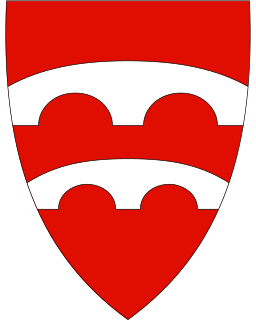
Hyllestad is a municipality in the county of Vestland, Norway. It is located in the traditional district of Sogn. The administrative center is the village of Hyllestad. Other villages in the municipality include Sørbøvågen and Leirvik. Hyllestad municipality has existed since 1862 when it was created from parts of the neighboring municipalities of Askvoll and Lavik. Hyllestad is located on the north side of the Sognefjorden, near the mouth of the fjord.

Askvoll (help·info) is a municipality in Vestland county, Norway. It is located in the traditional district of Sunnfjord. The administrative centre is the village of Askvoll. Other villages in the municipality include Holmedal, Kvammen, and Stongfjorden. The most important industries in Askvoll today are Helle Knivfabrikk, Bulandet Fiskeindustri, and Sigurd Løkeland Hermetikkfabrikk.
Fjaler is a municipality in the county of Vestland, Norway. It is located in the traditional district of Sunnfjord. The administrative centre is the village of Dale. Other places in Fjaler include Espedal, Flekke, Folkestad, Guddal, and Hellevika.

The school UWC Red Cross Nordic (UWCRCN), formerly known as Red Cross Nordic United World College, was founded in 1995 and is the ninth member of the today 18 United World Colleges, others having been established in Wales, Canada, Hong Kong, Italy, India, Singapore, Swaziland, United States, Costa Rica, the Netherlands, Bosnia & Herzegovina, Germany, Armenia, China, Thailand, Japan, and Tanzania. Patrons of the college and the movement include Nelson Mandela, Her Majesty Queen Noor of Jordan and Queen Sonja of Norway. The first college, UWC Atlantic College, was established by the German educationalist Kurt Hahn to promote international understanding and peace. Students are selected by UWC National Committees or selection contacts in over 150 countries on merit and many receive full scholarships. After the two-year education following the guidelines of the International Baccalaureate Diploma Program students usually go on to higher education. UWC students are eligible to participate in the Shelby Davis Scholarship program, which funds undergraduate studies for UWC students at many US universities. The school is led by the Acting Rektor, Jo Loiterton, and the Board of Governors, currently headed by former Conservative MP Kristin Vinje.

Verdalsøra is a town in the municipality of Verdal in Trøndelag county, Norway. The town is the administrative center of the municipality. It is located along the Trondheimsfjord at the mouth of the river Verdalselva. The village of Vinne lies 4 kilometres (2.5 mi) to the southeast, Trones lies about 5 kilometres (3.1 mi) to the north, the villages of Forbregd/Lein lie about 4 kilometres (2.5 mi) to the northeast, and the village of Stiklestad lies about 3 kilometres (1.9 mi) to the east. In 1998, the municipal council of Verdal voted to grant the urban area of Verdalsøra town status under the laws of Norway.
Selbekken is a village in the municipality of Orkland in Trøndelag county, Norway. The village is located directly south of the village of Lensvik along the Trondheimsfjorden and the Norwegian County Road 710. The 0.48-square-kilometre (120-acre) village has a population (2018) of 390 and a population density of 813 inhabitants per square kilometre (2,110/sq mi).

Moen is the administrative centre of Målselv Municipality in Troms og Finnmark county, Norway. The village of Moen is located in the Målselvdalen valley about 10 km (6.2 mi) north of the village of Andselv and Bardufoss Airport. The 0.89-square-kilometre (220-acre) village has a population (2017) of 847 which gives the village a population density of 952 inhabitants per square kilometre (2,470/sq mi).

Skarpengland is a village in Vennesla municipality in Vest-Agder county, Norway. The village is located along the Norwegian National Road 9 about 3 kilometres (1.9 mi) east of the village of Øvrebø and about 4 kilometres (2.5 mi) north of Homstean. The large village of Vennesla lies about 10 kilometres (6.2 mi) to the southeast and the city of Kristiansand lies about 23 kilometres (14 mi) to the south.
Skei is a village in Sunnfjord Municipality in Vestland county, Norway. The village is located at the northeastern end of the lake Jølstravatnet. Skei is 20 kilometres (12 mi) south of the village of Byrkjelo, 25 kilometres (16 mi) northeast of the villages of Vassenden/Langhaugane, and about 13 kilometres (8.1 mi) east of the village of Ålhus. Skei is located just west of Jostedalsbreen National Park. The village lies at the intersection of two major regional highways: European route E39 and Norwegian National Road 5. The village of Helgheim, where the Helgheim Church is located, sits about 4 kilometres (2.5 mi) west of Skei on the northern shore of the lake Jølstravatnet.
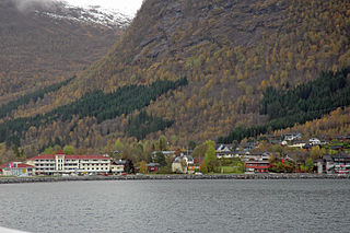
Dale or Dale i Sunnfjord is the administrative centre of the municipality of Fjaler in Vestland county, Norway. The village is located at the mouth of the river Vassdalselva on the southern shore of the Dalsfjorden in the northern part of Fjaler, about 6.5 kilometres (4.0 mi) northeast of the village of Flekke and about 20 kilometres (12 mi) west of the village of Bygstad.

Dalsfjorden is a fjord in Vestland county, Norway. It is located in the municipalities of Askvoll, Fjaler, and Sunnfjord. It is one of the two main fjords that comprise the Sunnfjord region of the county. The fjord is about 40 kilometres (25 mi) long and it is generally about 0.5 to 1 kilometre wide.

Sparbu is a village in the municipality of Steinkjer in Trøndelag county, Norway. The village is located about 12 kilometres (7.5 mi) south of the town of Steinkjer. The European route E6 highway runs through the village as does the Nordlandsbanen railway line which stops at the Sparbu Station. The village of Mære lies about 2 kilometres (1.2 mi) to the north, the village of Røra lies about 8 kilometres (5.0 mi) to the south, and the lake Leksdalsvatnet lies about 8 kilometres (5.0 mi) to the east.
Espedal is a valley and hamlet in the municipality of Fjaler in Vestland county, Norway. It is located about 12 kilometres (7.5 mi) southwest of the municipal center of Dale, and about 8 kilometres (5.0 mi) southwest of the village of Flekke. The area is owned by the Espedal family.

Haus or Hausvik is a village in Osterøy municipality in Hordaland county, Norway. The village is located on the southwestern coast of the island of Osterøy along the Sørfjorden. The village lies across the Sørfjorden from the villages of Ytre Arna and Garnes. The village of Valestrandfossen lies about 7 kilometres (4.3 mi) north along the fjord. The 0.38-square-kilometre (94-acre) village has a population (2013) of 619, giving the village a population density of 1,629 inhabitants per square kilometre (4,220/sq mi).
Søfteland or Syfteland is a village in Os municipality in Hordaland county, Norway. It lies on the Bergen Peninsula, along the European route E39 highway, about 6 kilometres (3.7 mi) north of the municipal centre of Osøyro and about 20 kilometres (12 mi) south of the city of Bergen. The mountain Møsnuken lies about 3.5 kilometres (2.2 mi) east of the village and the mountain Lyshornet lies about 2.3 kilometres (1.4 mi) west of the village. The 0.94-square-kilometre (230-acre) village has a population (2013) of 1425, giving the village a population density of 1,516 inhabitants per square kilometre (3,930/sq mi).

Rensvik is a village in Kristiansund Municipality in Møre og Romsdal county, Norway. The village is located on the northern part of the island of Frei, just west of the Omsund Bridge which connects to the island of Nordlandet to the north. The 1.7-square-kilometre (420-acre) village has a population (2018) of 2,532 and a population density of 1,489 inhabitants per square kilometre (3,860/sq mi).

Guddal is a village in Fjaler Municipality in Vestland county, Norway. The village is located about 20 kilometres (12 mi) southeast of the village of Flekke, in the Guddalen valley. The village of Vadheim lies about 25 kilometres (16 mi) to the southeast of Guddal. The village is the site of Guddal Church, which serves the whole valley. The local economy is centered on agriculture and forestry.

Sørbøvågen is a village in Hyllestad Municipality in Vestland county, Norway. The village is located along the northern shore of the Hyllestadfjorden. It is located about 10 kilometres (6.2 mi) northwest of the village of Hyllestad, the administrative centre of the municipality. The village of Hellevika lies about 10 kilometres (6.2 mi) to the north. Sørbøvågen is a small village, but it has a retirement/nursing home, a community hall, a billiards club, and it is the site of Øn Church which serves the northwestern third of the municipality.

Jondal is the administrative centre of Jondal municipality in Hordaland county, Norway. The village is located on the southern shore of the Hardangerfjorden, about 55 kilometres (34 mi) southeast of the city of Bergen. It is located on the Folgefonna peninsula, about 12 kilometres (7.5 mi) northwest of the Folgefonna glacier in Folgefonna National Park. The village of Kysnesstranda lies about 15 kilometres (9.3 mi) to the south. The 0.59-square-kilometre (150-acre) village has a population (2013) of 379, giving the village a population density of 642 inhabitants per square kilometre (1,660/sq mi).

