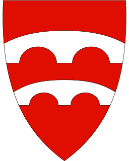
Jondal is a municipality in Hordaland county, Norway. It is located on the Folgefonna peninsula in the Hardanger district, on the eastern shore of the Hardangerfjorden. The administrative centre of the municipality is the village of Jondal. Other villages in Jondal include Herand, Kysnesstranda, and Torsnes.

Fundin is a lake in the municipalities of Folldal in Hedmark county and Oppdal in Trøndelag county, Norway. The 9.72-square-kilometre (3.75 sq mi) lake has a dam at the south end of it, holding back the water for hydroelectric power production, before letting it flow into the Einunna river.

Norheimsund is the administrative centre of the municipality of Kvam in Hordaland county, Norway. The village is located on the northern side of the Hardangerfjord, about 80 kilometres (50 mi) from the city of Bergen. The village of Øystese lies about 4 kilometres (2.5 mi) to the northeast and the village of Vikøy lies about 3 kilometres (1.9 mi) southeast of Norheimsund. The village of Steine is a suburb, immediately to the west of Norheimsund. The 2.5-square-kilometre (620-acre) village has a population (2012) of 2,224; giving the village a population density of 890 inhabitants per square kilometre (2,300/sq mi), the largest settlement in the whole municipality.

Røldal is a village in the municipality of Odda in Hordaland county, Norway. The village lies in the Røldal valley along the Storelva river on the north end of the lake Røldalsvatnet. Røldal is located about 35 kilometres (22 mi) southeast of the town of Odda. Røldal was formerly part of the independent municipality of Røldal from 1838 until 1964 when it became a part of Odda municipality. The 13th-century Røldal Stave Church is located here.

Holmavatnet is a lake the Setesdalsheiene mountains of Southern Norway. It is located on the border of the municipalities of Suldal, Vinje, and a small part in Bykle. The southeastern corner of the lake is in Bykle, and it is the northernmost part of all of Aust-Agder county. The lake Skyvatn is located about 5 kilometres (3.1 mi) to the south of the lake.
Veivatnet is a lake in the municipality of Ullensvang in Hordaland county, Norway. The 4.64-square-kilometre (1.79 sq mi) lake lies on the vast Hardangervidda plateau, inside Hardangervidda National Park. It is located about 15 kilometres (9.3 mi) southeast of the village of Lofthus and about 30 kilometres (19 mi) northeast of the town of Odda.

Hamlagrøvatnet is a lake on the border of the municipalities of Voss and Kvam in Hordaland county, Norway. The 10.3-square-kilometre (4.0 sq mi) lake is the largest lake in all of Hordaland county. The lake is located about 17 kilometres (11 mi) southeast of the village of Dalekvam and about 10 kilometres (6.2 mi) south of the village of Evanger.

Juvatn or Gjuvvatnet is a lake in the municipality of Åseral in Vest-Agder county, Norway. The 8.06-square-kilometre (3.11 sq mi) lake lies on the river Logna in the upper part of the Mandalen valley. The lake is in the far northeastern part of the municipality, just over 1.2 kilometres (0.75 mi) south of the border with Bygland municipality in Aust-Agder county. The Bortelid ski area lies just west of the lake. There is a dam on the southern part of the lake to use the water as part of a hydro-electric power system in the region. The dam was built in 1958 as part of the Logna power system. The water ultimately flows into the river Mandalselva. The nearby lake Gyvatn lies about 8 kilometres (5.0 mi) southeast of Juvatn.
Øljusjøen is a lake in the municipalities of Hemsedal and Lærdal, Norway. The 8.45-square-kilometre (3.26 sq mi) lake is located at an elevation of 1,335 metres (4,380 ft) above sea level. It sits about 15 kilometres (9.3 mi) southeast of the village of Borgund and the European route E16 highway. The lake Eldrevatnet is 4 kilometres (2.5 mi) to the north. The lake Juklevatnet and the mountain Høgeloft are both about 12 kilometres (7.5 mi) to the northeast.

Viddalsdammen is a lake and a reservoir in the municipality of Aurland in Sogn og Fjordane county, Norway. The reservoir has an area of 4.13-square-kilometre (1.59 sq mi) and the elevation varies between 930 metres (3,050 ft) and 868 m (2,848 ft) above sea level. Viddalsdammen is located at the end of the Låvisdalen valley, about 11 kilometres (6.8 mi) southeast of Aurlandsvangen, about 7 kilometres (4.3 mi) southeast of Flåm, and about 6 kilometres (3.7 mi) northeast of Myrdal Station.

Flekke is a village in the municipality of Fjaler in Sogn og Fjordane, Norway.

Doggejávri is a lake in Kvalsund Municipality in Finnmark county, Norway. The 2.96-square-kilometre (1.14 sq mi) lake lies about 10 kilometres (6.2 mi) southeast of the village of Oldernes, not far from the European route E06 highway.
Olden is a village and urban area in the municipality of Stryn in Sogn og Fjordane county, Norway. Olden is located at the mouth of the Oldeelva river at the northern end of the Oldedalen valley on the southern shore of the Nordfjorden. The 0.57-square-kilometre (140-acre) village has a population (2013) of 498, giving the village a population density of 874 inhabitants per square kilometre (2,260/sq mi). Olden is located about 6 kilometres (3.7 mi) southwest of the village of Loen, about a 16 kilometres (9.9 mi) drive southeast of the municipal center of Stryn, and about 15 kilometres (9.3 mi) east of the village of Innvik.

Eikesdalen is a valley and a settlement in Nesset Municipality in Møre og Romsdal county, Norway. The river Aura flows through the valley. The village is located at the south end of the lake Eikesdalsvatnet at the mouth of the Aura River. Most of the valley is filled by the lake and until 1991 ferry on the lake was the only access between north and south of the valley.. The Mardalsfossen waterfall lies about 2.5 kilometres (1.6 mi) northwest of the village. Most of the river Aura is diverted to Sunndalen and used in the power station there. The village of Eresfjord is located about 25 kilometres (16 mi) north, at the other end of the lake. The lake Aursjøen lies about 20 kilometres (12 mi) southeast of Eikesdalen village. Eikesdal Church is located in this village.

Askland is a village in Åmli municipality in Aust-Agder county, Norway. The village is located in the Gjøvdal valley, just north of the river Gjøv. The village of Homdrom lies about 9 kilometres (5.6 mi) to the southeast and the municipal centre of Åmli lies about 20 kilometres (12 mi) to the southeast. From 1908 until 1960, the Gjøvdal valley was the separate municipality of Gjøvdal which had Askland as its administrative centre. Gjøvdal Church is located in Askland.
Naustdal is the administrative centre of Naustdal Municipality in Sogn og Fjordane county, Norway. The village is located on the northern shore of the Førdefjorden at the mouth of the river Nausta, which flows through the Naustdalen valley. The village sits about 12 kilometres (7.5 mi) northwest of the town of Førde and about 10 kilometres (6.2 mi) northeast of the village of Helle. Kletten Hill rises southeast of the village.

Haukedalen Church is a parish church in Førde Municipality in Sogn og Fjordane county, Norway. It is located in the village of Haukedalen. The church is part of the Holsen og Haukedalen parish in the Sunnfjord deanery in the Diocese of Bjørgvin. The white, wooden church was built in 1885 by the architect Hartvig Sverdrup Eckhoff. The church, which seats about 120 people, was consecrated on 8 July 1885.

Guddal Church is a parish church in Fjaler Municipality in Sogn og Fjordane county, Norway. It is located in the village of Guddal. The church is part of the Fjaler parish in the Sunnfjord deanery in the Diocese of Bjørgvin. The church, which has 135 seats, was originally built in 1686. It was consecrated again on 25 September 1870 after an extensive expansion. The master builder who was responsible for the expansion of the church was John Alver. The church was almost completely rebuilt, so 1870 is considered to be the date it was built even though some parts of the church are much older.
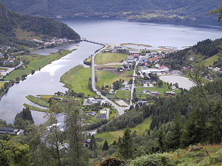
Jondal is the administrative centre of Jondal municipality in Hordaland county, Norway. The village is located on the southern shore of the Hardangerfjorden, about 55 kilometres (34 mi) southeast of the city of Bergen. It is located on the Folgefonna peninsula, about 12 kilometres (7.5 mi) northwest of the Folgefonna glacier in Folgefonna National Park. The village of Kysnesstranda lies about 15 kilometres (9.3 mi) to the south. The 0.59-square-kilometre (150-acre) village has a population (2013) of 379, giving the village a population density of 642 inhabitants per square kilometre (1,660/sq mi).