Stad, Norway

Last updated
Stad Municipality
Stad kommune
View Selje.jpg
View of the Selje area and the Stad peninsula
Stad komm.svg
Norway Counties Vestland Position.svg
Vestland within Norway
NO 4649 Stad.svg
Stad within Vestland
Coordinates: 61°54′41″N6°02′14″E / 61.91139°N 6.03722°E / 61.91139; 6.03722
Country Norway
County Vestland
District Nordfjord
Established1 Jan 2020
  Preceded by Selje, Eid, Vågsøy
Administrative centre Nordfjordeid
Government
  Mayor (2023)Sigurd Reksnes (Sp)
Area
  Total752.77 km2 (290.65 sq mi)
  Land694.53 km2 (268.16 sq mi)
  Water58.25 km2 (22.49 sq mi)  7.7%
  Rank#152 in Norway
Population
 (2023)
  Total9,543
  Rank#119 in Norway
  Density13.7/km2 (35/sq mi)
  Change (10 years)
Increase2.svg +9.6%
Demonym Stadværing [1]
Official language
[2]
   Norwegian form Nynorsk
Time zone UTC+01:00 (CET)
  Summer (DST) UTC+02:00 (CEST)
ISO 3166 code NO-4649 [3]
Website Official website

Stad is a municipality in Vestland county, Norway. It is located in the traditional district of Nordfjord. The municipality includes much of the northern shore of the Nordfjorden as well as the Stad peninsula. [4] The administrative centre of the municipality is the village of Nordfjordeid. Other villages in the municipality include Selje, Barmen, Ervik, Flatraket, Hoddevik, Hoddevika, Håvik, Leikanger, Mogrenda, Stårheim, Haugen, Kjølsdalen, Heggjabygda, and Lote.

Contents

The 753-square-kilometre (291 sq mi) municipality is the 152nd largest by area out of the 356 municipalities in Norway. Stad is the 119th most populous municipality in Norway with a population of 9,543. The municipality's population density is 13.7 inhabitants per square kilometre (35/sq mi) and its population has increased by 9.6% over the previous 10-year period. [5] [6]

The Stad Ship Tunnel is a planned canal and tunnel to bypass the Stad peninsula in Stad Municipality in Vestland county, Norway. When built it will be the first full-size ship tunnel in the world and will allow boats to avoid traveling around the Stad peninsula—a particularly dangerous sea route.

General information

The municipality of Stad was established on 1 January 2020 when Selje Municipality, Eid Municipality, and the Bryggja area of Vågsøy Municipality were merged to form one large municipality. [4]

Name

The municipality is named after the Stad peninsula (Old Norse : Staðr) which is located in the western part of the municipality. The name is identical to the word staðr which means "stop", "halt", or "hesitation". The name possibly was used for the peninsula because of the rough waters around it which often caused seafarers here to wait for better weather. [7]

Coat of arms

The coat of arms was granted on 15 May 2019 for use starting on 1 January 2020 when the municipality was established. The blazon is "Azure, " (Norwegian : NORSKE_BLAZON). This means the arms have a teal-colored field (background) and the charge is a two-part design with St. Sunniva on the left and a fjord horse on the right. The charge has a tincture of argent which means it is commonly colored white, but if it is made out of metal, then silver is used. The arms are an informal impalement of the old arms of the two municipalities of Selje and Eid which were merged in 2020 to form Stad. [8] These two figures were chosen because the region is well known for its own race of horses, called the Fjording, that are very common and popular in the area. The Fjording is characterised by its white and black mane. [9] The woman is a depiction of Saint Sunniva, the royal Irish missionary who died as a martyr on the island of Selja while trying to convert the locals to Christianity. Later, the Selje Abbey was built on the spot where she died. She was later named the patron saint of the Norwegian Diocese of Bjørgvin and all of Western Norway. [10] The municipal flag has the same design as the coat of arms. [11]

Churches

The Church of Norway has six parishes (sokn) within the municipality of Stad. It is part of the Nordfjord prosti (deanery) in the Diocese of Bjørgvin.

Churches in Stad
Parish (sokn)Church nameLocation of the churchYear built
Eid Eid Church Nordfjordeid 1849
Heggjabygda Church Heggjabygda 1936
Ervik Ervik Church Ervik 1970
Kjølsdalen Kjølsdalen Church Kjølsdalen 1940
Leikanger Leikanger Church Leikanger 1866
Selje Selje Church Selje 1866
Stårheim Stårheim Church Stårheim 1864

Geography

The village of Arvik on the Stad peninsula Stadt Arvik.jpg
The village of Årvik on the Stad peninsula
The village of Drage on the Stad peninsula Stadt Drage.jpg
The village of Drage on the Stad peninsula
Hundvikfjord seen from Anda Hundvikfjorden from Anda.JPG
Hundvikfjord seen from Anda
Isefjord, between Eid and Bremanger Isefjorden.JPG
Isefjord, between Eid and Bremanger

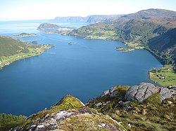
Stad Municipality is located in the northwesternmost part of Vestland county, in the Nordfjord region. It includes the Stad peninsula and the islands of Barmøya, Venøya, and Selja. The Sildagapet bay, the North Sea, and the Vanylvsfjorden lie on the western sides of the municipality. The Nordfjorden runs along the south side of the municipality. Hornindalsvatnet, the deepest lake in Europe, is partially located in the municipality.

Stad Municipality is bordered to the southwest by Kinn Municipality, to the north by Vanylven Municipality, Sande Municipality, and Volda Municipality (in Møre og Romsdal county). The municipalities of Bremanger and Gloppen lie to the south, across the fjord. Stryn Municipality lies to the east.

Government

Stad Municipality is responsible for primary education (through 10th grade), outpatient health services, senior citizen services, welfare and other social services, zoning, economic development, and municipal roads and utilities. The municipality is governed by a municipal council of directly elected representatives. The mayor is indirectly elected by a vote of the municipal council. [12] The municipality is under the jurisdiction of the Sogn og Fjordane District Court and the Gulating Court of Appeal.

Municipal council

The municipal council (Kommunestyre) of Stad is made up of 31 representatives that are elected to four year terms. The tables below show the current and historical composition of the council by political party.

Stad kommunestyre 20232027 [13]   
Party name (in Nynorsk)Number of
representatives
  Labour Party (Arbeidarpartiet)5
  Progress Party (Framstegspartiet)4
  Green Party (Miljøpartiet Dei Grøne)1
  Conservative Party (Høgre)3
  Industry and Business Party (Industri og Næringspartiet)2
  Christian Democratic Party (Kristeleg Folkeparti)2
  Centre Party (Senterpartiet)10
  Socialist Left Party (Sosialistisk Venstreparti)1
  Liberal Party (Venstre)3
Total number of members:31
Stad kommunestyre 20202023 [14]   
Party name (in Nynorsk)Number of
representatives
  Labour Party (Arbeidarpartiet)4
  Progress Party (Framstegspartiet)3
  Conservative Party (Høgre)2
  Christian Democratic Party (Kristeleg Folkeparti)2
  Centre Party (Senterpartiet)9
  Socialist Left Party (Sosialistisk Venstreparti)2
  Liberal Party (Venstre)11
Total number of members:33

Mayors

The mayors (Nynorsk : ordførar) of Stad:

Notable people

Sophus Lie, 1896 Portrett av Sophus Lie.jpg
Sophus Lie, 1896

Related Research Articles

<span class="mw-page-title-main">Sogn og Fjordane</span> Former county of Norway

Sogn og Fjordane was, up to 1 January 2020, a county in western Norway, when it was merged to become part of Vestland county. Bordering previous counties Møre og Romsdal, Oppland, Buskerud, and Hordaland, the county administration was in the village of Hermansverk in Leikanger municipality. The largest town in the county was Førde.

<span class="mw-page-title-main">Etne</span> Municipality in Vestland, Norway

Etne is a municipality in Vestland county, Norway. It is located in the traditional district of Sunnhordland, although it is also sometimes considered to be part of the district of Haugaland. The administrative centre of the municipality is the village of Etnesjøen. Other villages in the municipality include Skånevik and Fjæra. The two largest villages in the municipality are Etnesjøen with 1,159 residents and Skånevik with 594 residents.

<span class="mw-page-title-main">Kvam</span> Municipality in Vestland, Norway

Kvam is a municipality in Vestland county, Norway. The municipality is located along the Hardangerfjorden in the traditional district of Hardanger. The administrative centre of the municipality is the village of Norheimsund. Other larger settlements in the municipality include Øystese, Bru, Ålvik, Tørvikbygd, Omastranda, and Mundheim. Historically, the municipality was named Vikør.

<span class="mw-page-title-main">Samnanger</span> Municipality in Vestland, Norway

Samnanger is a municipality in the Midhordland region of Vestland county, Norway. The administrative centre of the municipality is the village of Tysse. Other main villages in the municipality include Haga and Bjørkheim in Nordbygda. The municipality is located about 20 kilometres (12 mi) east of the city of Bergen, Norway's second largest city. It surrounds the inner part of the Samnangerfjorden and the surrounding valleys. There are mountains that surround the municipality. The development of hydroelectric power plants started here in 1909.

<span class="mw-page-title-main">Modalen</span> Municipality in Vestland, Norway

Modalen is a municipality in the Nordhordland district in the central part of Vestland county in Norway. The administrative centre of the municipality is the village of Mo. The other main village in the municipality is Øvre Helland. Most of the residents of Modalen live in the main Modalen valley which extends eastwards from the end of the Romarheimsfjorden.

<span class="mw-page-title-main">Bremanger</span> Municipality in Vestland, Norway

Bremanger is a municipality in Vestland county, Norway. The village of Svelgen is the administrative centre of the municipality. Other villages include Bremanger, Berle, Davik, Isane, Kalvåg, Svelgen, Rugsund, and Ålfoten. Bremanger is the only municipality in Vestland, which is located in two districts. The northern and eastern parts comprising the villages of Oldeide, Berle, Rugsund, Davik, Isane, and Ålfoten is located in the Nordfjord region, while the villages of Bremanger, Kalvåg, Svelgen, Sørgulen, and Botnane are located in the Sunnfjord region. Politically, the municipality works with the Nordfjord region in the council of Nordfjord municipalities.

<span class="mw-page-title-main">Vågsøy</span> Former municipality in Sogn og Fjordane, Norway

Vågsøy is a former municipality in the old Sogn og Fjordane county, Norway. It was located in the traditional district of Nordfjord. The municipality's administrative center was the town Måløy. Other population centers in Vågsøy included the villages of Bryggja, Deknepollen, Holvika, Kvalheim, Langeneset, Raudeberg, Refvika, Silda, Tennebø, Totland, Vedvika, and Vågsvåg. The municipality included the island of Vågsøy, several small surrounding islands, and part of the mainland. On 1 January 2020, the municipality was dissolved and divided between Kinn Municipality and Stad Municipality in Vestland county.

<span class="mw-page-title-main">Selje</span> Former municipality in Sogn og Fjordane, Norway

Selje is a former municipality in the old Sogn og Fjordane county, Norway and was located in the traditional district of Nordfjord. The village of Selje was the administrative center this municipality. Other villages and neighborhoods in the municipality included Barmen, Ervik, Flatraket, Hoddevik, Hoddevika, Håvik, and Leikanger. On 1 January 2020 the municipality became part of the new Stad Municipality in the newly formed Vestland county.

<span class="mw-page-title-main">Gloppen</span> Municipality in Vestland, Norway

Gloppen is a municipality in the county of Vestland, Norway. It is located in the traditional district of Nordfjord. Gloppen is generally subdivided into three areas: Hyen in the west, Gloppen in the center, and Breim in the east.

<span class="mw-page-title-main">Stryn</span> Municipality in Vestland, Norway

Stryn is a municipality in the county of Vestland, Norway. It is located in the traditional district of Nordfjord. The administrative center of the municipality is the village of Stryn. The municipality is located along the innermost part of the Nordfjorden. Some of the main villages in Stryn include Loen, Innvik, Utvik, Randabygda, Olden, and Flo.

<span class="mw-page-title-main">Eid, Norway</span> Former municipality in Sogn og Fjordane, Norway

Eid is a former municipality in the county of Sogn og Fjordane, Norway. It was located in the traditional district of Nordfjord. The village of Nordfjordeid was the administrative center of the municipality. Other larger villages in Eid included Mogrenda, Stårheim, Haugen, Kjølsdalen, Heggjabygda, and Lote.

<span class="mw-page-title-main">Nordfjord</span> District in Vestland, Norway

Nordfjord is a traditional district of Norway.

Stårheim is a village in the municipality of Stad in Vestland county, Norway. Stårheim is located in the central part of Stad Municipality on the north shore of the Nordfjorden, about 12 kilometres (7.5 mi) west of the municipal center of Nordfjordeid and about 8 kilometres (5.0 mi) east of the village of Kjølsdalen. There is a regularly scheduled ferry route from Stårheim to the small village of Isane, located about 4 kilometres (2.5 mi) south across the Nordfjorden.

Bryggja is a village in southwestern part of Stad Municipality in Vestland county, Norway. It is located on the mainland, along the northern shore of the Nordfjorden. The village is located about 15 kilometres (9.3 mi) east of the urban areas of Måløy–Deknepollen–Tennebø in Kinn Municipality and it is about 25 kilometres (16 mi) west of the village of Stårheim. The small village of Totland lies just west of Bryggja.

<span class="mw-page-title-main">Nordfjorden (Vestland)</span> Fjord in Norway

Nordfjorden is the sixth longest fjord in Norway. It flows through the municipalities of Stryn, Gloppen, Stad, Bremanger, and Kinn, and it is the central feature of the entire Nordfjord region which makes up the northern third of the county.

<span class="mw-page-title-main">Vestland</span> County of Norway

Vestland is a county in Norway established on 1 January 2020. The county is located in Western Norway and it is centred around the city of Bergen, Norway's second largest city. The administrative centre of the county is the city of Bergen, where the executive and political leadership is based, but the County Governor is based in Hermansverk. The county is one of two counties in Norway that have Nynorsk as their official written language form.

<span class="mw-page-title-main">Fjord (municipality)</span> Municipality in Møre og Romsdal, Norway

Fjord is a municipality in Møre og Romsdal county, Norway. It is located in the traditional district of Sunnmøre. The administrative centre of the municipality is the village of Stordal. Other villages in the municipality include Valldal, Eidsdal, Norddal, Tafjord, Fjørå/Selboskarbygda, Sylte. The name Fjord is a common word and name part in Norway and was chosen for the new municipality established in 2020 for reasons of search engine optimization, despite not having any historical tradition in the municipality.

<span class="mw-page-title-main">Kinn</span> Municipality in Vestland, Norway

Kinn is a municipality in Vestland county, Norway. It was established on 1 January 2020. It is in the traditional districts of Nordfjord and Sunnfjord. The municipality is the only non-contiguous municipality in Norway since the municipality of Bremanger lies in between the north and south parts of Kinn. The administrative centres of the municipality is the two cities of Florø and Måløy. Some villages in the municipality include Rognaldsvåg, Stavang, Grov, Norddalsfjord, Nyttingnes, Steinhovden, Brandsøy, Deknepollen, Holvika, Kvalheim, Langeneset, Raudeberg, Refvika, Silda, Tennebø, Vedvika, and Vågsvåg.

<span class="mw-page-title-main">Sunnfjord (municipality)</span> Municipality in Vestland, Norway

Sunnfjord is a municipality in Vestland county, Norway. It is located in the traditional district of Sunnfjord. The administrative centre of the municipality is the town of Førde. Other villages in the municipality include Naustdal, Sande, Vassenden, and Skei.

<span class="mw-page-title-main">Midt-Telemark (municipality)</span> Municipality in Telemark, Norway

Midt-Telemark is a municipality in Telemark county, Norway. It is located in the traditional district of Midt-Telemark. The administrative centre of the municipality is the village of Bø i Telemark. Other villages in the municipality include Akkerhaugen, Folkestad, Gvarv, Holtsås, Nordagutu, Nordbøåsane, and Sauherad.

References

  1. "Navn på steder og personer: Innbyggjarnamn" (in Norwegian). Språkrådet.
  2. "Forskrift om målvedtak i kommunar og fylkeskommunar" (in Norwegian). Lovdata.no.
  3. Bolstad, Erik; Thorsnæs, Geir, eds. (26 January 2023). "Kommunenummer". Store norske leksikon (in Norwegian). Kunnskapsforlaget.
  4. 1 2 Paus, Mari, ed. (20 September 2019). "Stad - kommune". Store norske leksikon (in Norwegian). Kunnskapsforlaget . Retrieved 5 October 2019.
  5. Statistisk sentralbyrå. "Table: 06913: Population 1 January and population changes during the calendar year (M)" (in Norwegian).
  6. Statistisk sentralbyrå. "09280: Area of land and fresh water (km²) (M)" (in Norwegian).
  7. Askheim, Svein, ed. (20 September 2019). "Stad". Store norske leksikon (in Norwegian). Kunnskapsforlaget . Retrieved 5 October 2019.
  8. "Kommunevåpen for Stad kommune klart!" (in Norwegian). Stad kommune. 15 May 2019. Retrieved 5 October 2019.
  9. "Civic heraldry of Norway - Norske Kommunevåpen". Heraldry of the World. Retrieved 5 October 2019.
  10. "Civic heraldry of Norway - Norske Kommunevåpen". Heraldry of the World. Retrieved 22 October 2017.
  11. "Civic heraldry of Norway - Norske Kommunevåpen". Heraldry of the World. Retrieved 12 May 2023.
  12. Hansen, Tore; Vabo, Signy Irene, eds. (20 September 2022). "kommunestyre". Store norske leksikon (in Norwegian). Kunnskapsforlaget . Retrieved 14 October 2022.
  13. "Kommunestyrevalg 2023 - Vestland". Valgdirektoratet . Retrieved 21 January 2024.
  14. "Kommunestyrevalg 2019 - Vestland". Valgdirektoratet . Retrieved 5 October 2019.
  15. "Gunnar Silden". Venstre.no (in Norwegian). Retrieved 13 May 2023.
  16. Gloppestad, Aadne (12 September 2023). "Reksnes blir ny ordførar i Stad, Kjøllesdal held fram i Stryn". Firda Tidend (in Norwegian). Retrieved 21 January 2024.
  17. "Lie, Marius Sophus"  . Encyclopædia Britannica . Vol. 16 (11th ed.). 1911. p. 590.
  18. Sølve Skagen at IMDb. Retrieved 20 November 2020.