
Sogn og Fjordane was up to 1 January 2020 a county in western Norway, when it was merged to become part of Vestland county. Bordering previous counties Møre og Romsdal, Oppland, Buskerud, and Hordaland, the county administration was in the village of Hermansverk in Leikanger municipality. The largest town in the county was Førde.

Gloppen is a municipality in the county of Vestland, Norway. It is located in the traditional district of Nordfjord. Gloppen is generally subdivided into three areas: Hyen in the west, Gloppen in the center, and Breim in the east.

Stryn is a municipality in the county of Vestland, Norway. It is located in the traditional district of Nordfjord. The administrative center of the municipality is the village of Stryn. The municipality is located along the innermost part of the Nordfjorden. Some of the main villages in Stryn include Loen, Innvik, Utvik, Randabygda, Olden, and Flo.

Eid is a former municipality in the county of Sogn og Fjordane, Norway. It was located in the traditional district of Nordfjord. The village of Nordfjordeid was the administrative center of the municipality. Other larger villages in Eid included Mogrenda, Stårheim, Haugen, Kjølsdalen, Heggjabygda, and Lote.

Sula (help·info) is a municipality in Møre og Romsdal county, Norway. It is part of the Sunnmøre district. The administrative centre is the village of Langevåg. Other villages include Solevåg, Fiskarstrand, Veibust, Leirvågen, and Mauseidvågen. Sula is one of the most densely populated municipalities in Møre og Romsdal county, and it is part of the Ålesund Region since it is just south of the city of Ålesund. The municipality encompasses the island of Sula and the many small surrounding islets.

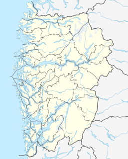
Nordfjord is a traditional district of Norway.

E39 is the designation of a 1330 km long north-south road in Norway and Denmark, running from Klett just south of Trondheim to Aalborg, via Orkanger, Vinjeøra, Halsa ... Straumsnes, Krifast, Batnfjordsøra, Molde ... Vestnes, Skodje, Ålesund ... Volda ... Nordfjordeid ... Sandane, Førde, Lavik ... Instefjord, Knarvik, Bergen, Os ... Stord, Sveio, Aksdal, Bokn ... Rennesøy, Randaberg, Stavanger, Sandnes, Ålgård, Helleland, Flekkefjord, Lyngdal, Mandal, Kristiansand ... Hirtshals, Hjørring, and Nørresundby. Several sections are via ferry, denoted by ... in the above list. In total there are nine ferries, the highest number of ferries for a single road in Europe.

Davik is a former municipality in the traditional district of Nordfjord in the old Sogn og Fjordane county, Norway. The 654-square-kilometre (253 sq mi) former municipality existed from 1838 until 1964 and it encompassed all the lands surrounding the outer part of the large Nordfjorden on both sides of the fjord. Davik was located in parts of the present-day municipalities of Kinn, Bremanger, and Stad. The administrative center of the former municipality was the village of Davik which is located on the southern shore of the Nordfjorden, although some of the municipal services were based out of the village of Bryggja on the north side of the fjord, since that village was the largest village in Davik municipality.

Nordfjordeid is the administrative centre of the municipality of Stad in Vestland county, western Norway. It is located at the end of the Eidsfjorden, an arm off of the main Nordfjorden, west of the large lake Hornindalsvatnet. The village of Stårheim is located about 12 kilometres (7.5 mi) to the west, the village of Mogrenda is about 5 kilometres (3.1 mi) to the east, and the village of Lote is about 7 kilometres (4.3 mi) to the southeast.

Sandane is the administrative centre of the municipality of Gloppen in Vestland county, Norway. It is located at the end of the Gloppefjorden, along the European route E39 highway. Sandane is 20 kilometres (12 mi) south of the village of Nordfjordeid and about 16 kilometres (9.9 mi) west of the village of Byrkjelo. Sandane Airport, Anda is located 10 kilometres (6.2 mi) northwest of Sandane along highway E39. Sandane has several suburban areas that surround the nearby fjord such as Sørstranda to the west and Vereide to the northwest.
Mogrenda is a village in the municipality of Stad in Vestland county, Norway. The village is located at the western end of the lake Hornindalsvatnet along the river Eidselva. It is about 5 kilometres (3.1 mi) east of the village of Nordfjordeid, about 10 kilometres (6.2 mi) north of the village of Lote, and about 10 kilometres (6.2 mi) west of the village of Heggjabygda.
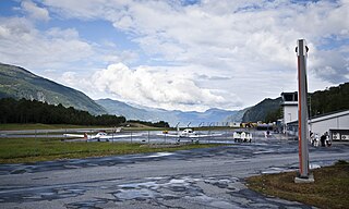
Sandane Airport, Anda is a regional airport serving the village of Sandane in Vestland county, Norway. It perpendicularly straddles the Anda peninsula in Gloppen Municipality between the Nordfjorden and Gloppefjorden. The airport has an asphalt runway measuring 970 by 30 meters and aligned 09/27. Services are provided by Widerøe on public service obligation with the Ministry of Transport and Communications. The airport is owned and operated by the state-owned Avinor and served 37,272 passengers in 2013.

Kandal is a small village located along the west side of the lake Breimsvatnet, about 15 kilometres (9.3 mi) southeast of the municipal center of Sandane in the municipality of Gloppen in Sogn og Fjordane county, Norway. The population of Kandal (2001) is 87, and the village area stretches along the shore of the lake for about 5 kilometres (3.1 mi).
Stårheim is a village in the municipality of Stad in Vestland county, Norway. Stårheim is located in the central part of Stad Municipality on the north shore of the Nordfjorden, about 12 kilometres (7.5 mi) west of the municipal center of Nordfjordeid and about 8 kilometres (5.0 mi) east of the village of Kjølsdalen. There is a regularly scheduled ferry route from Stårheim to the small village of Isane, located about 4 kilometres (2.5 mi) south across the Nordfjorden.
Isane is a village in Bremanger Municipality in Vestland county, Norway. It has a ferry connection to the village of Stårheim, located about 4 kilometres (2.5 mi) northeast across the Nordfjorden in Stad Municipality. The population (2001) of Isane is 42. Since 2006, the village has become an important seaport for importing yellowfin tuna.

Byrkjelo is a village in the municipality of Gloppen in Vestland county, Norway. It is located about halfway between the villages of Sandane and Skei along the European route E39 highway. The village of Re lies about 5 kilometres (3.1 mi) to the west and the small village of Egge lies about 5 kilometres (3.1 mi) to the south.
Bryggja is a village in southwestern part of Stad Municipality in Vestland county, Norway. It is located on the mainland, along the northern shore of the Nordfjorden. The village is located about 15 kilometres (9.3 mi) east of the urban areas of Måløy–Deknepollen–Tennebø in Kinn Municipality and it is about 25 kilometres (16 mi) west of the village of Stårheim. The small village of Totland lies just west of Bryggja.

Nordfjorden is the sixth longest fjord in Norway. It flows through the municipalities of Stryn, Gloppen, Stad, Bremanger, and Kinn, and it is the central feature of the entire Nordfjord region which makes up the northern third of the county.

Re or Reed is a village in Gloppen Municipality in Vestland county, Norway. The village is located on the eastern shore of the lake Breimsvatnet, along the European route E39 highway, about 5 kilometres (3.1 mi) west of the village of Byrkjelo and about 12 kilometres (7.5 mi) southeast of the municipal centre of Sandane.

Stad is a municipality in Vestland county, Norway. It is located in the traditional district of Nordfjord. The municipality includes much of the northern shore of the Nordfjorden as well as the Stad peninsula. The administrative centre of the municipality is the village of Nordfjordeid. Other villages in the municipality include Selje, Barmen, Ervik, Flatraket, Hoddevik, Hoddevika, Håvik, Leikanger, Mogrenda, Stårheim, Haugen, Kjølsdalen, Heggjabygda, and Lote.


