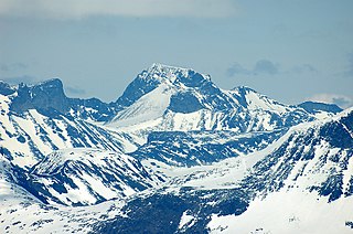
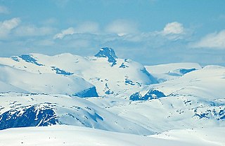
Galdhøpiggen is the highest mountain in Norway, Scandinavia, and Northern Europe. The 2,469-metre-tall (8,100 ft) mountain is located in Lom Municipality in Innlandet county, Norway. It is in the Jotunheimen mountains within Jotunheimen National Park. The mountain sits about 25 kilometres (16 mi) southwest of the village of Fossbergom and about 45 kilometres (28 mi) northeast of the village of Øvre Årdal. The mountain is surrounded by several other notable mountains including Keilhaus topp to the east; Store Styggehøe to the southeast; Svellnosbreahesten, Midtre Tverråtinden, and Store Tverråtinden to the south; Storjuvtinden and Skardstinden to the west; Veslpiggen, Storgrovtinden, and Storgrovhøe to the northwest; and Galdhøi and Juvvasshøi to the northeast.
Glittertind or Glittertinden is a mountain in Lom Municipality in Innlandet county, Norway. The 2,452-metre (8,045 ft) tall mountain is the second highest mountain in Norway. It is located in the Jotunheimen mountains within Jotunheimen National Park. The mountain sits about 22 kilometres (14 mi) southeast of the village of Fossbergom and about 38 kilometres (24 mi) southwest of the village of Vågåmo. The mountain is surrounded by several other notable mountains including Trollsteineggje, Trollsteinrundhøe, and Svartholshøe to the north; Grotbreahesten to the northeast; Veslekjølen to the east; Austre Hestlægerhøe and Nautgardstinden to the southeast; Steinbukampen and Veopallan to the south; and Galdhøpiggen to the west.
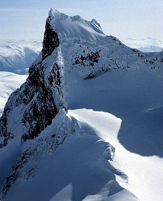
Store Skagastølstind is the third highest peak in Norway. It is situated on the border between the municipality of Luster and Årdal in Vestland county, Norway. The 2,405-metre (7,890 ft) mountain is part of the Hurrungane range. The mountains Vetle Skagastølstind and Midtre Skagastølstind lie immediately to the north of this mountain and the mountains Sentraltind and Jervvasstind lie immediately to the east of this mountain.

Snøhetta is the highest mountain in the Dovrefjell mountain range in Norway. At 2,286 metres (7,500 ft), it is the highest mountain in Norway outside the Jotunheimen range, making it the 24th highest peak in Norway, based on a 30-metre (98 ft) topographic prominence cutoff. At 1,675 metres (5,495 ft), its topographic prominence is the third highest in Norway.

Fannaråki is a mountain in the municipality of Luster in Vestland county, Norway. The 2,068-metre (6,785 ft) tall mountain is located in the Jotunheimen National Park, just south of the lake Prestesteinsvatnet and the Sognefjellsvegen road. This mountain is located about 6 kilometres (3.7 mi) north of the Skagastølstindane mountains.

Nautgardstind or Nautgardstinden is a mountain on the border of Vågå Municipality and Lom Municipality in Innlandet county, Norway. The 2,258-metre (7,408 ft) tall mountain is located in the Jotunheimen mountains within Jotunheimen National Park. The mountain sits about 35 kilometres (22 mi) southwest of the village of Vågåmo. The mountain is surrounded by several other notable mountains including Hindnubben and Stornubben to the northeast; Heranoshøi to the north; Glittertinden to the northwest; Nautgardsoksli, Austre Hestlægerhøe, and Vestre Hestlægerhøe to the west; Besshø to the south; and Russlirundhøe to the east.
Torfinnstindene is a mountain in Vang Municipality in Innlandet county, Norway. The 2,118-metre (6,949 ft) tall mountain is located in the Jotunheimen mountains, about 25 kilometres (16 mi) north of the village of Vang i Valdres. The mountain is surrounded by several other notable mountains including Rasletinden and Kalvehøgde to the northeast, Nørdre Kalvehølotinden to the east, Galdeberget and Oksedalshøi to the west, and Langedalstinden to the northwest.

Kalvehøgde is a mountain group in Vågå Municipality and Vang Municipality in Innlandet county, Norway. The 2,209-metre (7,247 ft) tall mountain is located in the Jotunheimen mountains. The mountain sits about 60 kilometres (37 mi) southwest of the village of Vågåmo and about 20 kilometres (12 mi) northwest of the village of Beitostølen. The mountain is surrounded by several other notable mountains including Rasletinden to the east; Tjønnholstinden and Tjønnholsoksle to the north; Skarvflytindene, Leirungskampen, and Leirungstinden to the northwest; and Torfinnstindene to the west.

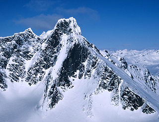
Skarstind or Skardstinden is a prominent part of the Galdhøpiggen mountain range in northwestern Jotunheimen, Norway, and is the sixth highest summit in the country. The mountain has three summits, the main summit at 2,373 metres (7,785 ft) above sea level, Nåle at 2,310 metres (7,580 ft) and the small western summit at 2,215 metres (7,267 ft). It is located within the municipality of Lom in Innlandet county. The mountain is located on the eastern side of the Leirdalen valley, and the summit can be seen from the road along the valley floor. There are several other peaks in the vicinity, but only Galdhøpiggen, a few kilometers to the east, is higher. The mountain can be seen from most of the higher peaks in Jotunheimen and Breheimen to the northwest.
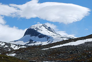
Lodalskåpa is the highest nunatak on the Norwegian glacier Jostedalsbreen. It is located on the border between the municipalities of Stryn and Luster in Vestland county, Norway, within Jostedalsbreen National Park.

Jervvasstind is Norway's ninth-highest mountain. The 2,351-metre-tall (7,713 ft) mountain lies in the Hurrungane mountains in the eastern part of the municipality of Luster in Vestland county, Norway. It lies on the eastern end of a mountain ridge including the mountains Store Skagastølstind-Vetle Skagastølstind-Sentraltind-Store Styggedalstind-Jervvasstind. The village of Skjolden is located 16 kilometres (9.9 mi) to the west.

Sentraltind is a mountain in the Hurrungane mountains in the Jotunheimen mountain range. The 2,348-metre (7,703 ft) tall mountain is located in the eastern part of the municipality of Luster in Vestland county, Norway. It is the 10th highest summit in Norway. Sentraltind lies on a ridge between Store Skagastølstind-Vetle Skagastølstind and Store Styggedalstind-Jervvasstind. The mountain is 16 kilometres (9.9 mi) east of the village of Skjolden.

Store Knutsholstinden is a mountain in Vågå Municipality in Innlandet county, Norway. The 2,342-metre (7,684 ft) tall mountain is located in the Jotunheimen mountains within Jotunheimen National Park. The mountain sits about 60 kilometres (37 mi) southwest of the village of Vågåmo and about 25 kilometres (16 mi) northwest of the village of Beitostølen. The mountain is surrounded by several other notable mountains including Skarvflytindene to the east, Leirungstinden and Vesle Knutsholstinden to the southeast, Store Svartdalspiggen to the west, and Nordre Knutsholstinden to the north.
Storjuvtinden is a mountain in Lom Municipality in Innlandet county, Norway. The 2,344-metre (7,690 ft) tall mountain is located in the Jotunheimen mountains within Jotunheimen National Park. The mountain sits about 25 kilometres (16 mi) southwest of the village of Fossbergom and about 45 kilometres (28 mi) northeast of the village of Øvre Årdal. The peak is on the massif between the valleys Leirdalen and Visdalen. The mountain is surrounded by several other notable mountains including Galdhøpiggen and Keilhaus topp to the northeast; Svellnosbreahesten, Midtre Tverråtinden, and Store Tverråtinden to the southeast; Bukkehøe to the southwest; Skardstinden to the west; Storgrovtinden and Storgrovhøe to the northwest; and Veslpiggen to the north.
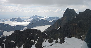
Hurrungane is a mountain range in the municipalities Luster and Årdal in Vestland county, Norway. The area is southwest in the larger mountain range Jotunheimen and is also part of Jotunheimen National Park.
Vetle Skagastølstinden is one of the peaks constituting Skagastølstindane in the Hurrungane mountain range and is among Norway's highest. The 2,340-metre (7,680 ft) tall mountain is located in the eastern part of the municipality of Luster in Vestland county, Norway. It lies directly between the mountains Midtre Skagastølstind, Store Skagastølstind, and Sentraltind. The mountains Store Styggedalstinden and Jervvasstind lie 1.5 kilometres (0.93 mi) to the east, and the village of Skjolden lies 15 kilometres (9.3 mi) to the west.

Tjønnholstinden or Tjørnholstind is a mountain in Vågå Municipality in Innlandet county, Norway. The 2,331-metre (7,648 ft) tall mountain is located in the Jotunheimen mountains within Jotunheimen National Park. The mountain sits about 50 kilometres (31 mi) southwest of the village of Vågåmo and about 25 kilometres (16 mi) northwest of the village of Beitostølen. The mountain is surrounded by several other notable mountains including Bukkehåmåren, Høgdebrotet, and Eggi to the northeast; Rasletinden to the southeast; Tjønnholsoksle to the south; Skarvflytindene and Leirungstinden to the southwest; and Surtningssue to the north.
Store Austanbotntind is a mountain on the border of the municipalities of Luster and Årdal in Vestland county, Norway. It is the highest peak in the western part of the Hurrungane mountain range. The mountain is located in Jotunheimen National Park, about 12.5 kilometres (7.8 mi) southeast of the village of Skjolden. The easiest route to the summit involves climbing, though relatively easy, and crossing of an exposed snow flank.

Midtre Skagastølstind is one of the peaks constituting Skagastølstindane in the Hurrungane mountain range. The 2,284-metre (7,493 ft) tall mountain lies in the eastern part of the municipality of Luster in Vestland county, Norway. The mountain lies in between Nordre Skagastølstind, Vetle Skagastølstind, and Store Skagastølstind. The mountains Store Styggedalstinden, Jervvasstind, and Sentraltind all lie about 1 to 2 kilometres to the east of this mountain. The village of Skjolden lies about 15 kilometres (9.3 mi) to the west.
Tverrådalskyrkja is a mountain on the border of Skjåk Municipality in Innlandet county and Luster Municipality in Vestland county, Norway. The 2,089-metre (6,854 ft) tall mountain is located in the Breheimen mountains and inside the Breheimen National Park, just north of the large Harbardsbreen glacier. It is 23 kilometres (14 mi) north of the village of Skjolden in Luster and 33 kilometres (21 mi) southwest of Bismo in Skjåk. The mountain is surrounded by several other notable mountains including Tundradalskyrkja to the east, Holåtindan to the southeast, Røykeskardhøi to the west, and Syrtbyttnosi to the northwest.


