Veitastrond

Last updated
Veitastrond
Village
Veitastrond I.jpg
Norway Sogn og Fjordane location map.svg
Red pog.svg
Veitastrond
Location in Sogn og Fjordane county
Norway location map.svg
Red pog.svg
Veitastrond
Veitastrond (Norway)
Coordinates: 61°28′21″N07°02′38″E / 61.47250°N 7.04389°E / 61.47250; 7.04389 Coordinates: 61°28′21″N07°02′38″E / 61.47250°N 7.04389°E / 61.47250; 7.04389
Country Norway
Region Western Norway
County Sogn og Fjordane
District Sogn
Municipality Luster
Elevation
[1]
174 m (571 ft)
Time zone UTC+01:00 (CET)
  Summer (DST) UTC+02:00 (CEST)
Post Code
6878 Veitastrond

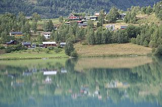
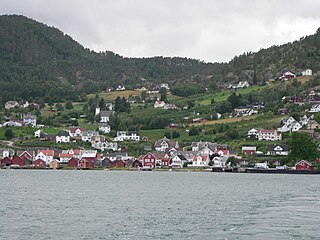
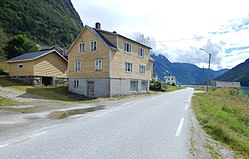
Veitastrond is a small village in the western part of the municipality of Luster in Sogn og Fjordane county, Norway. It is located near the Jostedalsbreen glacier, and Jostedalsbreen National Park surrounds the village on three sides. Veitastrond is located at the northern end of an isolated valley. There is only one road access to Veitastrond, a 30-kilometre (19 mi) long road heading northwest from the village of Hafslo, the nearest urban center. Veitastrond sits about 45 kilometres (28 mi) from the village of Gaupne, the municipal center.

Luster, Norway Municipality in Sogn og Fjordane, Norway

Luster is a municipality in Sogn og Fjordane county, Norway. It is located at the end of the Sognefjorden in the traditional district of Sogn. The administrative centre is the village of Gaupne. Other villages in Luster include Fortun, Hafslo, Indre Hafslo, Jostedal, Luster, Nes, Ornes, Skjolden, Solvorn, and Veitastrond.

Sogn og Fjordane County (fylke) of Norway

Sogn og Fjordane is a county in western Norway, bordering Møre og Romsdal, Oppland, Buskerud, and Hordaland. The county administration is in the village of Hermansverk in Leikanger municipality. The largest town in the county is Førde.

Norway Country in Northern Europe

Norway, officially the Kingdom of Norway, is a Nordic country in Northern Europe whose territory comprises the western and northernmost portion of the Scandinavian Peninsula; the remote island of Jan Mayen and the archipelago of Svalbard are also part of the Kingdom of Norway. The Antarctic Peter I Island and the sub-Antarctic Bouvet Island are dependent territories and thus not considered part of the kingdom. Norway also lays claim to a section of Antarctica known as Queen Maud Land.

The village has 123 inhabitants who share a small shop, a school (9 pupils), and Veitastrond Chapel. The economy is primarily based on agriculture. The Storelvi river passes by the village before emptying into the long lake Veitastrondsvatnet.

Veitastrond Chapel Church in Sogn og Fjordane, Norway

Veitastrond Chapel is a chapel in Luster Municipality in Sogn og Fjordane county, Norway. It is located in the village of Veitastrond. The chapel is part of the Hafslo parish in the Indre Sogn deanery in the Diocese of Bjørgvin. The white, wooden chapel has 120 seats and was built as a bedehus in 1928. On 14 July 1935, it was consecrate to be used for church functions and received the designation of chapel. Before that time, the villagers had to make the 30-kilometre (19 mi) long trek from their isolated village to Hafslo Church, which was a long and sometimes dangerous journey.

Agriculture Cultivation of plants and animals to provide useful products

Agriculture is the science and art of cultivating plants and livestock. Agriculture was the key development in the rise of sedentary human civilization, whereby farming of domesticated species created food surpluses that enabled people to live in cities. The history of agriculture began thousands of years ago. After gathering wild grains beginning at least 105,000 years ago, nascent farmers began to plant them around 11,500 years ago. Pigs, sheep and cattle were domesticated over 10,000 years ago. Plants were independently cultivated in at least 11 regions of the world. Industrial agriculture based on large-scale monoculture in the twentieth century came to dominate agricultural output, though about 2 billion people still depended on subsistence agriculture into the twenty-first.

Historically, Veitastrond was part of the municipality of Hafslo from 1838 until 1 January 1963 when Hafslo municipality merged into Luster municipality. [2]

Hafslo Former Municipality in Western Norway, Norway

Hafslo is a former municipality in Sogn og Fjordane county, Norway. It is located in the present-day municipality of Luster in the traditional district of Sogn. The former municipality included the villages of Kinsedalen, Ornes, and Kroken on the east side of the Lustrafjorden. It also included the villages of Solvorn, Hafslo, Joranger, and the whole Veitastrond valley on the west side of the Lustrafjorden. The municipality surrounded the lakes Hafslovatnet and Veitastrondvatnet. The administrative centre of the municipality was the village of Hafslo, where Hafslo Church was located.

The former Sogndal-player Kurt Heggestad hails from Veitastrond. [3]

Sogndal Fotball Sogndal ILs association football section

Sogndal Fotball is the association football department of Norwegian sports club Sogndal IL from Sogndal in Sogn og Fjordane. The club was founded in 1926.

Kurt Heggestad is a Norwegian former professional footballer who played as a left winger or left-back. He represented Norway at the under-16 and under-17 level, and played 53 matches for Sogndal in Tippeligaen. Heggestad played for Sogndal for ten consecutive seasons, before he retired at the age of 26 to become a goat farmer.

Related Research Articles

Jølster Municipality in Sogn og Fjordane, Norway

Jølster is a municipality in Sogn og Fjordane county, Norway. It is located in the traditional district of Sunnfjord. The administrative centre is the village of Skei. Other villages in the municipality include Helgheim, Ålhus, Vassenden, and Langhaugane.

Stryn Municipality in Sogn og Fjordane, Norway

Stryn is a municipality in the county of Sogn og Fjordane, Norway. It is located in the traditional district of Nordfjord. The administrative center of the municipality is the village of Stryn. The municipality is located along the innermost part of the Nordfjorden. Some of the main villages in Stryn include Loen, Innvik, Utvik, Randabygda, Olden, and Flo.

Jostedalsbreen National Park national park of Norway

Jostedalsbreen National Park is a national park in Norway that encompasses the largest glacier on the European mainland, Jostedalsbreen. The park was established by royal decree on 25 October 1991, and then in 1998, it was enlarged to the northwest. The park now covers 1,310 square kilometres (510 sq mi), with the glaciers covering about 800 square kilometres (310 sq mi) of the park.

Gaupne Village in Western Norway, Norway

Gaupne is the administrative center of the municipality of Luster in Sogn og Fjordane county, Norway. The 1.28-square-kilometre (320-acre) village has a population (2013) of 1,157; giving the village a population density of 904 inhabitants per square kilometre (2,340/sq mi). The village is located along the Gaupnefjorden, an arm of the Lustrafjorden, about 10 kilometres (6.2 mi) north of the village of Hafslo. The village of Veitastrond is located across the mountains 20 kilometres (12 mi) to the northwest. The Sognefjellsvegen road passes through here on its way to the village of Skjolden and beyond.

Skjolden Village in Western Norway, Norway

Skjolden is a village in the municipality of Luster in Sogn og Fjordane county, Norway. It is located at the end of the Lustrafjorden, a branch of the Sognefjorden. Skjolden is located at the innermost point of the Sognefjorden, Norway's longest fjord, and the length of the Sognefjorden is measured from Skjolden to the island of Ytre Sula where the fjord meets the ocean—over 200 km. The valleys of Mørkridsdal and Fortunsdal meet at Skjolden, just west of the Hurrungane mountains. Skjolden is home to about 200 people.

Jostedal Village and Former Municipality in Sogn og Fjordane, Norway

Jostedal is a village and a former municipality in Sogn og Fjordane county in Norway. It is located in the northern part of the present-day municipality of Luster, about 22 kilometres (14 mi) north of Gaupne. The village of Jostedal currently has around 410 inhabitants (2008).

Oppstrynsvatn lake in Stryn, Norway

Oppstrynsvatn is a lake in the municipality of Stryn in Sogn og Fjordane county, Norway. It is located about 8 kilometres (5.0 mi) east of the village of Stryn. The villages of Flo, Oppstryn, and Erdal are located on the shores of the lake.

Austdalsvatnet is a lake in the northwestern part of the municipality of Luster in Sogn og Fjordane county, Norway. It is located in the Breheimen mountain range at the end of the Austdalsbreen glacier, just north of the lake Styggevatnet. It is about 10 kilometres (6.2 mi) east of Lodalskåpa and Brenibba, in the Jostedalsbreen glacier. The water is regulated by a dam on lake Styggevatnet and it empties into the Jostedøla river which flows south into the Gaupnefjord.

Loen Village in Western Norway, Norway

Loen is a village in Stryn Municipality in Sogn og Fjordane county, Norway. It is located in the inner part of the Nordfjord region, at the easternmost end of the Nordfjorden. Loen is located about 6 kilometres (3.7 mi) north of the village of Olden and about 11 kilometres (6.8 mi) southeast of the municipal center of Stryn. The lake Lovatnet is located just to the southeast of the village of Loen. The Hotel Alexandra was established in Loen in 1884. The historic Loen Church is also located in the village.

Brenibba mountain in Norway

Brenibba is a nunatak protruding from the north end of the Jostedalsbreen glacier in the Breheimen mountain range. It is located in the municipality of Luster in Sogn og Fjordane county, Norway. Brenibba is 2.5 kilometres (1.6 mi) south of Lodalskåpa and 12 kilometres (7.5 mi) northeast of Høgste Breakulen. It is part of the Jostedalsbreen National Park. The lakes Austdalsvatnet and Styggevatnet are located 11 kilometres (6.8 mi) west of Brenibba.

Breheimsenteret

The Breheimsenteret is a museum and one of the three visitors centers for Jostedalsbreen National Park. Opened in 1993, it was located near the Jostedøla river in the village of Jostedal, about 20 kilometres (12 mi) north of Gaupne and about 10 kilometres (6.2 mi) east of the Jostedalsbreen glacier in the municipality of Luster in Sogn og Fjordane county, Norway.

Styggevatnet

Styggevatnet is a glacial lake from the glacier Jostedalsbreen in the municipality of Luster in Sogn og Fjordane county, Norway. The lake lies just southeast of the lake Austdalsvatnet. The lake is regulated by a dam and it empties into the river Jostedøla. The lake is about 10 kilometres (6.2 mi) to the east of Lodalskåpa and Brenibba in Jostedalsbreen National Park.

Hafslo (village) Village in Western Norway, Norway

Hafslo is a village in Luster Municipality in Sogn og Fjordane county, Norway. The village is located on the northern shore of the lake Hafslovatnet, about 3 kilometres (1.9 mi) northwest of the village of Solvorn which sits on the shores of the Lustrafjorden. The lake Veitastrondvatnet is located to the northwest of Hafslo. The village of Sogndalsfjøra lies 15 kilometres (9.3 mi) to the south; the village of Gaupne lies about 15 kilometres (9.3 mi) to the north; and the village of Veitastrond lies about 25 kilometres (16 mi) to the northwest. The Norwegian County Road 55 runs through the village on its way from Sogndalsfjøra to Gaupne. The 0.25-square-kilometre (62-acre) village has a population (2013) of 457, giving the village a population density of 1,828 inhabitants per square kilometre (4,730/sq mi).

Solvorn Village in Western Norway, Norway

Solvorn is a village in Luster Municipality in Sogn og Fjordane county, Norway. The village is located on the western shore of the Lustrafjorden, the innermost part of the Sognefjorden. The village sits directly across the fjord from the village of Ornes, where the famous 12th-century Urnes Stave Church is located. The village of Hafslo lies about 4 kilometres (2.5 mi) to the northwest.

Fet Church (Luster) Church in Sogn og Fjordane, Norway

Fet Church is a parish church in Luster Municipality in Sogn og Fjordane county, Norway. It is located in the village of Fet in the Indre Hafslo area. The church is part of the Fet og Joranger parish in the Indre Sogn deanery in the Diocese of Bjørgvin. The white, wooden church, which has 220 seats, was built in 1894 by the master builder John Alver. The church was consecrated on 12 November 1894 by Bishop Frederick Waldemar Hvoslef.

Hafslo Church Church in Sogn og Fjordane, Norway

Hafslo Church is a parish church in Luster Municipality in Sogn og Fjordane county, Norway. It is located in the village of Hafslo. The church is part of the Hafslo parish in the Indre Sogn deanery in the Diocese of Bjørgvin. The white, wooden church, which has 300 seats, was built and consecrated on 4 December 1878. The architect J. Faye made the designs for the building. The church was built to replace the old stave church which stood from around the year 1200 until it was torn down in 1878.

References

  1. "Veitastrond" (in Norwegian). yr.no . Retrieved 2010-09-12.
  2. Jukvam, Dag (1999). "Historisk oversikt over endringer i kommune- og fylkesinndelingen" (PDF) (in Norwegian). Statistisk sentralbyrå.
  3. Tomasgard, Jørn-Arne (17 November 2008). "Valde geitene framfor fotballen". Bergens Tidende (in Norwegian). Archived from the original on 18 October 2008. Retrieved 6 January 2013.