
Tanzania is administratively divided into thirty-one regions.

Mbeya is a city located in south west Tanzania, Africa, with an urban population of 649,000 in 2023. Mbeya is the capital of the surrounding rural Mbeya region.
Mbeya Region is one of Tanzania's 31 administrative regions. The region covers an area of 35,954 km2 (13,882 sq mi). The region is comparable in size to the combined land area of the nation state of Guinea Bissau. Mbeya Region is bordered to the east by Singida Region, Iringa Region and Njombe Region. The region is bordered to the south by Malawi and Lake Nyasa. To the north the region borders southern Tabora Region. Lastly, Mbeya is bordered to the west by Songwe Region. The regional capital is the city of Mbeya. According to the 2022 national census, the region had a population of 2,343,754.

Chunya District is one of the seven districts of Mbeya Region, Tanzania. It is bordered to the north by Tabora Region, to the northeast by Singida Region, to the east by Mbarali District, to the south by Mbeya Rural District, and to the west by Songwe District.

Mbarali District is one of the seven districts of Mbeya Region, Tanzania. It is bordered to the north by Iringa region and east by Njombe region. To the south the district is bordered by Mbeya Rural District and to the west by Chunya District.

Mbozi District is a district in Songwe Region, Tanzania. It is bordered to the north by the Songwe District and Chunya District of the Mbeya Region, to the east by Mbeya Rural District of the Mbeya Region, to the south by the Ileje District and to the west by Momba District.
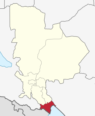
Kyela is one of the seven districts of Mbeya Region, Tanzania. It is bordered to the north by Rungwe District, to the northeast by Njombe Region, to the southeast by Lake Nyasa, to the south by Malawi and to the west by Ileje District.
As of 2021, there are 31 regions of Tanzania which are divided into 184 districts.
Nkangamo is an administrative ward in Momba District, Songwe Region, Tanzania. As of the 2022 census, it has a total population of 16,804. According to the 2002 census, the ward was in the Mbozi District and had a total population of 8,122. A 400 kV transmission line is in the planning phase and would terminate within Tanzania around Nkangamo.
Katumba Songwe, also Katumbasongwe, is an administrative ward in the Kyela District of the Mbeya Region of Tanzania. In 2016 the Tanzania National Bureau of Statistics report there were 8,615 people in the ward, from 13,895 in 2012.
Ngonga is an administrative ward in the Kyela district of the Mbeya Region of Tanzania. The village is on Lake Nyasa by the Songwe River that forms the Tanzania and Malawi border, and thirty minute drive from the border crossing in Kasumulu. The ward covers an area of 339.4 square kilometres (131.0 sq mi) with an average elevation of 482 metres (1,581 ft).
Kinyala is an administrative ward in the Rungwe District of the Mbeya Region of Tanzania. In 2016 the Tanzania National Bureau of Statistics report there were 14,185 people in the ward, from 12,871 in 2012.
Bonde la Usongwe, is a administrative ward in Mbeya Rural in the Mbeya Region of Tanzania. The ward covers an area of 103.1 square kilometres (39.8 sq mi) with an average elevation of 1,431 metres (4,695 ft).
Iwiji is an administrative ward in the Mbeya Rural district of the Mbeya Region of Tanzania. In 2016 the Tanzania National Bureau of Statistics report there were 9,973 people in the ward, from 15,056 in 2012.

Katavi Region is one of Tanzania's 31 administrative regions. The region covers an area of 45,843 km2 (17,700 sq mi). The region is comparable in size to the combined land area of the nation state of Estonia. Katavi Region is bordered to the east by Tabora Region. The region is bordered to the south by Rukwa Region and Songwe Region. Lastly, Katavi borders DRC on Lake Tanganyika to the west. The region derives its name from Katavi, the spirit of lake Tanganyika. The regional capital city is Mpanda. According to the 2022 national census, the region had a population of 1,152,958.

Songwe Airport, usually referred to in flight schedules as Mbeya, is an airport located in the southern highland region of Mbeya Region, Tanzania, serving the city of Mbeya. it is the largest Airport in southwest Tanzania. Also, due to its proximity to the regional border, it serves the Songwe Region as well. It is 20 kilometres (12 mi) west of the city, off the A104 trunk road, and is able to accommodate commercial jet traffic, whereas the unpaved Mbeya Airport is not.

Momba District is a district of Songwe Region, Tanzania. It is bordered to the north by Lake Rukwa, to the south by Zambia, to the east by the Mbozi District, and to the west by the Rukwa Region. It was formed from the western part of Mbozi District when Songwe Region was created from Mbeya Region.

Songwe Region is one of Tanzania's 31 administrative regions. The region covers a land area of 27,656 km2 (10,678 sq mi). The region is comparable in size to the combined land area of the nation state of Haiti. Songwe Region borders the countries of Zambia and Malawi to the south: Tunduma is the main entry point into Zambia while Isongole is the main entry point into Malawi. Songwe also borders the Tanzanian regions of Rukwa and Katavi in the west, Tabora in the north, and Mbeya in the east. Lake Rukwa is a major body of water in the western part of the region. The region was created on 29 January 2016 from the western half of Mbeya Region. The regional capital is Vwawa. According to the 2022 national census, the region had a population of 1,344,687.
Ipunga is a ward in the Mbozi District of Songwe Region, Tanzania. Its postal code is 53316. In 2016 the Tanzania National Bureau of Statistics report there were 10,657 people in the ward, from 9,367 in 2012.
Mpimbwe District is a district council in the Katavi Region of Tanzania's Southern Highlands established in 2012. The district lies in the south of the region on Lake Rukwa.
