
A ghost town is an abandoned village, town, or city, usually one that contains substantial visible remains. A town often becomes a ghost town because the economic activity that supported it has failed, or due to natural or human-caused disasters such as floods, prolonged droughts, government actions, uncontrolled lawlessness, war, pollution, or nuclear disasters. The term can sometimes refer to cities, towns, and neighbourhoods that are still populated, but significantly less so than in past years; for example, those affected by high levels of unemployment and dereliction.

A village is a clustered human settlement or community, larger than a hamlet but smaller than a town, with a population ranging from a few hundred to a few thousand. Though villages are often located in rural areas, the term urban village is also applied to certain urban neighborhoods. Villages are normally permanent, with fixed dwellings; however, transient villages can occur. Further, the dwellings of a village are fairly close to one another, not scattered broadly over the landscape, as a dispersed settlement.
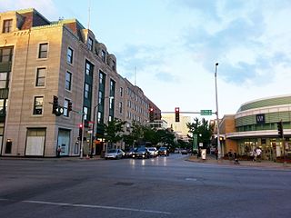
Oak Park is a village adjacent to the West Side of Chicago, Illinois. It is the 29th largest municipality in Illinois as measured by population in the 2010 U.S. census. As of the 2010 United States Census the village had a population of 51,878.

South Holland is a village in Cook County, Illinois, United States, within Thornton Township. The population was 22,030 at the 2010 census.

Algonquin is a village in McHenry and Kane counties, Illinois, in the United States. It is a suburb of Chicago, located approximately 40 miles (64 km) northwest of the Loop. As of the 2010 census the village's population was 30,046, and as of 2017 the estimated population was 31,017.

South Orange, officially the Township of South Orange Village, is a suburban township in Essex County, New Jersey, United States. As of the 2010 United States Census, the village's population was 16,198, reflecting a decline of 766 (-4.5%) from the 16,964 counted in the 2000 Census, which had in turn increased by 574 (+3.5%) from the 16,390 counted in the 1990 Census. Seton Hall University is located in the township.

South Kingstown is a town in Washington County, Rhode Island, United States. The population was 30,639 at the 2010 census. South Kingstown is the largest town in Washington County and is the largest town in the state of Rhode Island.
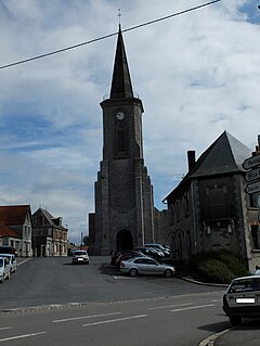
Croisilles is a village and commune in the Pas-de-Calais department of the Hauts-de-France region of France.

Notre Dame is a census-designated place north of South Bend in St. Joseph County, in the U.S. state of Indiana. It includes the campuses of three colleges: the University of Notre Dame, Saint Mary's College, and Holy Cross College. Notre Dame is split between Clay and Portage Townships. As of the 2010 census, its population was 5,973.
A village, in the context of New Jersey local government, is one of five types and one of eleven forms of municipal government.
The following is a list of lists of the cities, towns and villages of the United States separated by state, territory or district name.

A fishing village is a village, usually located near a fishing ground, with an economy based on catching fish and harvesting seafood. The continents and islands around the world have coastlines totalling around 356,000 kilometres (221,000 mi). From Neolithic times, these coastlines, as well as the shorelines of inland lakes and the banks of rivers, have been punctuated with fishing villages. Most surviving fishing villages are traditional.
Arthenac is a French commune in the Charente-Maritime department in the Nouvelle-Aquitaine region of south-western France.

Aisy-sous-Thil is a commune in the Côte-d'Or department in the Bourgogne region of eastern France.

Achery is a French commune in the department of Aisne in the Hauts-de-France region of northern France.

Agnin is a French commune in the Isère department in the Auvergne-Rhône-Alpes region of south-eastern France.

Aulnois-sous-Laon is a commune in the department of Aisne in the Hauts-de-France region of northern France.
Midakanatti (ಮಿಡಕನಟ್ಟಿ) is a small village in the Gokak Taluk and Belagavi District of Karnataka State in India. It is administered by the Midakanatti Panchayat. It is located 33 km east of the divisional headquarters in Belagavi, 18 km from the town of Gokak, and 452 km from the State capital, Bengaluru.
Udayan Vihar is a locality in Guwahati, surrounded by localities of Satgaon, Narengi and Noonmati.
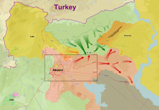
The East Aleppo offensive (2017), also referred to as the Dayr Hafir offensive (2017), was an operation launched by the Syrian Army to prevent Turkish-backed rebel forces from advancing deeper into Syria, and also to ultimately capture the ISIL stronghold of Dayr Hafir. Another aim of the operation was to gain control of the water source for Aleppo city, at the Khafsa Water Treatment Plant, in addition to capturing the Jirah Military Airbase. At the same time, the Turkish-backed rebel groups turned towards the east and started launching attacks against the Syrian Democratic Forces, west of Manbij.


