
Tuolumne County, officially the County of Tuolumne, is a county in the U.S. state of California. As of the 2010 census, the population was 54,539. The county seat and only incorporated city is Sonora.

The East Walker River is an approximately 90 miles (140 km) long, tributary of the Walker River, in eastern California and western Nevada in the United States. It drains part of the eastern side of the Sierra Nevada in the watershed of Walker Lake in the Great Basin. Recently boated successfully. The river provides continuous Class IV for kayaks and IK at high water. Be aware many ranchers have placed barbed wire illegally across the river in a number of places on both the CA and NV sides of the river.

The West Walker River is a tributary of the Walker River, approximately 95 miles (153 km) long, in eastern California and western Nevada in the United States. It drains part of the Sierra Nevada range along the California-Nevada border in the watershed of Walker Lake in the Great Basin. The river derives its name from Joseph R. Walker, a mountain man.
State Route 120 is a state highway in the U.S. state of California, running west to east across the central part of the state. It runs from Interstate 5 in the San Joaquin Valley near Lathrop through Yosemite National Park, to its end at U.S. Route 6 in Mono County, eastern California. While the route is signed as a contiguous route through Yosemite National Park, the portion in park boundaries is federally maintained, and is not included in the state route logs. The portion at Tioga Pass is the highest paved through road in the California State Route system. This part is not maintained in the winter and is usually closed during the winter season.

Lee Vining is a census-designated place in Mono County, California, United States. It is located 21 miles (34 km) south-southeast of Bridgeport, at an elevation of 6781 feet. Lee Vining is located on the southwest shore of Mono Lake. The population was 222 as of the 2010 census, down from 250 reported as of 2000 by Mono County. At the previous census (1990) the town population was 398, and at the census before that (1980) it was 315.

Dog Town is a ghost town in Mono County, California. Today, Dog Town is a defunct gold rush era town in Mono County, California. It is located at 38°10′13″N119°11′51″W, on Dog Creek, near the junction of Clearwater and Virginia Creeks, about 6 miles (10 km) south-southeast of Bridgeport, at an elevation of 7057 feet.

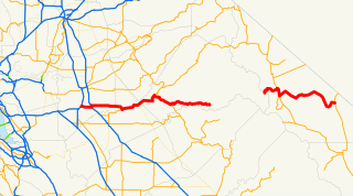
State Route 108 is a state highway in the U.S. state of California that runs from the Central Valley and across the Sierra Nevada via the Sonora Pass. It generally runs northeast from downtown Modesto near the SR 99/SR 132 interchange, to U.S. Route 395 near the Nevada state line. The route was once recommended to continue south of Modesto to Interstate 5, although today that portion exists as a county road. Parts of SR 108 are closed annually during the winter due to inclement weather along the summit.

Sonora Pass is the second-highest highway pass in the Sierra Nevada, lower by 321 ft. than Tioga Pass to the south. State Route 108 traverses the pass.

Devil's Gate Pass is a mountain pass in Mono County, California, traversed by U.S. Route 395. The pass is named for the Devils Gate, a granitic formation located west of the summit of the pass.

The state highway system in the U.S. state of California dates back to 1896, when the state took over maintenance of the Lake Tahoe Wagon Road. Construction of a large connected system began in 1912, after the state's voters approved an $18 million bond issue for over 3000 miles (4900 km) of highways. The last large addition was made by the California State Assembly in 1959, after which only minor changes have been made.

Sonora Peak is a mountain in the Central Sierra Nevada of California north of Sonora Pass. Located on the boundary between Alpine and Mono counties, it is the highest point in Alpine County. Due to the high elevation, most of the precipitation this mountain receives consists of snow.
U.S. Route 395 (US 395) is a United States Numbered Highway, stretching from Hesperia, California to the Canadian border in Laurier, Washington. The California portion of US 395 is a 557-mile (896 km) route which traverses from Interstate 15 in Hesperia, north to the Oregon state line in Modoc County near Goose Lake. The route clips into Nevada, serving the cities Carson City and Reno, before returning to California.

June Lake is a census-designated place in Mono County, California. It is located against the southern rim of the Mono Basin, 12.5 miles (20 km) south of Lee Vining, at an elevation of 7654 feet.

Benton is a census-designated place in Mono County, California, United States. It is located 3 miles (4.8 km) east-northeast of the community of Benton Hot Springs and 32 miles (51 km) north of the community of Bishop, at an elevation of 5387 feet. The population was 280 at the 2010 census, up from 196 reported at 2000 by Mono County.
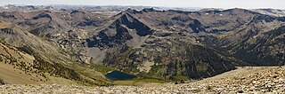
Leavitt Peak is located in the Emigrant Wilderness near Sonora Pass in the eastern Sierra Nevada range of California. Leavitt Peak is located on the Tuolumne County - Mono County line. The Pacific Crest Trail runs close to the east of Leavitt Peak, at an elevation of about 10,800 feet (3,290 m) elevation. The peak offers views south to Yosemite National Park and north towards South Lake Tahoe.
Hiram Leavitt (1824–1901) was an early settler, innkeeper, and judge in Mono County, California, in the eastern Sierra Nevada. Leavitt left his mark in the area and is the namesake of features such as Leavitt Peak, Leavitt Meadow, Leavitt Creek and Leavitt Lake.

Mono Hot Springs is a summer resort and campground at a group of hot springs in Fresno County, central California. It is located within the Sierra National Forest, 70 miles (110 km) northeast of Fresno via California State Route 168.

Fales Hot Springs is a hot spring in the Sonora Junction area of Mono County, eastern California.

Mono Mills is a ghost town in Mono County, California. It is located 9.5 miles (15 km) east-southeast of Lee Vining, at an elevation of 7356 feet. Mono Mills has nearly vanished. Its site is along California State Route 120, 9.1 miles (15 km) east from the junction with U.S. Route 395.
Teofulio Summit, formerly Warner Pass, a pass that lies at an elevation of 3681 feet in the San Felipe Hills of the Peninsular Ranges of San Diego County, California. This pass was named for Teofulio Helm (1874-1967), a prominent member of the Cupeno Band of Mission Indians, who homesteaded in the area.

