
The Vaal Dam in South Africa was constructed in 1938 and lies 77 km south of OR Tambo International Airport. The lake behind the dam wall has a surface area of about 320 square kilometres (120 sq mi) and is 47 meters deep. The Vaal Dam lies on the Vaal River, which is one of South Africa's strongest-flowing rivers. Other rivers flowing into the dam are the Wilge River, Klip River, Molspruit and Grootspruit. It has over 800 kilometres (500 mi) of shoreline and is South Africa's second biggest dam by area and the fourth largest by volume.

Ghaghara, also called Karnali is a perennial trans-boundary river originating on the Tibetan Plateau near Lake Manasarovar. The Karnali cuts through the Himalayas in Nepal and joins the Sharda River at Brahmaghat in India. Together they form the Ghaghara River, a major left bank tributary of the Ganges. With a length of 507 kilometres (315 mi) it is the longest river in Nepal. The total length of Ghaghara River up to its confluence with the Ganges at Revelganj in Bihar is 1,080 kilometres (670 mi). It is the largest tributary of the Ganges by volume and the second longest tributary of the Ganges by length after Yamuna.

The Daman Ganga also called Dawan River is a river in western India. The river's headwaters are on the western slope of the Western Ghats range, and it flows west into the Arabian Sea. The river flows through Maharashtra and Gujarat states, as well as the Union territory of Dadra and Nagar Haveli and Daman and Diu. The industrial towns of Vapi, Dadra and Silvassa lie on the north bank of the river, and the town of Daman occupies both banks of the river's estuary.
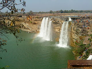
Indravati River is a tributary of the Godavari River, in central India.
Windamere Dam is a minor ungated rock fill with clay core embankment dam with an uncontrolled unlined rock cutting spillway across the Cudgegong River at Cudgegong, upstream of Mudgee in the Central Tablelands of New South Wales, Australia. The dam's purpose includes hydro-power, irrigation, water supply, and conservation. The impounded reservoir is called Lake Windamere.
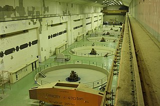
The Haditha Dam or Qadisiya Dam is an earth-fill dam on the Euphrates, north of Haditha (Iraq), creating Lake Qadisiyah. The dam is just over 9 kilometres (5.6 mi) long and 57 metres (187 ft) high. The purpose of the dam is to generate hydroelectricity, regulate the flow of the Euphrates and provide water for irrigation. It is the second-largest hydroelectric contributor to the power system in Iraq behind the Mosul Dam.
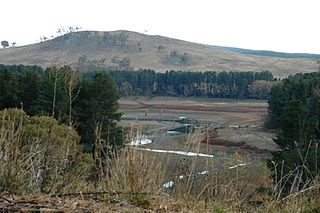
Suma Park Dam is a concrete arch dam across the Summer Hill Creek in the central west region of New South Wales, Australia. The main purpose of the dam is to supply potable water to the city of Orange. The impounded reservoir is called Suma Park Reservoir.

The ponmudi dam is a concrete gravity dam built across the Panniyar river which is a tributary of Periyar River at Konnathadi panchayath of Konnathadi village in Idukki district of Kerala, India. The dam was constructed in 1963 as a part of a hydroelectric project. It has a length of 294 metres (965 ft) and a length of 288.80 metres (947.5 ft). The hydropower component of the dam has an installed capacity of 30 MW with firm power of 17 MW, generating 158 GWh annually. Taluks through which the river flow are Udumpanchola, Devikulam, Kothamangalam, Muvattupuzha, Kunnathunadu, Aluva, Kodungalloor and Paravur.

Toonumbar Dam is a minor ungated rock fill with clay core embankment dam with a concrete chute spillway across the Iron Pot Creek north-west of Casino in the Northern Rivers region of New South Wales, Australia. The dam's purpose includes hydro-power, irrigation, water supply, and conservation. The impounded reservoir is called Lake Toonumbar.
The Kayacık Dam impounds the Ayfinar Deresi, one of the two streams that join south of Gaziantep to form the Sajur River. It is located in Gaziantep Province, Turkey. The dam was constructed between 1993 and 2005 as part of the Southeastern Anatolia Project. It is 45 metres (148 ft) high and has a volume of 1,853,000 cubic metres (65,400,000 cu ft). The reservoir created by the Kayacık Dam has a surface area of 11 square kilometres (4.2 sq mi) and a volume of 0.117 cubic kilometres (0.028 cu mi) and is used to irrigate an area of 200 square kilometres (77 sq mi).
The Engineer Souza Dias Dam, formerly known as the Jupiá Dam is an embankment dam on the Paraná River near Três Lagoas in Mato Grosso do Sul, Brazil. It was constructed for hydroelectric power production, flood control and navigation. Studies on the dam and power plant began in 1951 which recommended the dam along with the Ilha Solteira Dam. The dam was inaugurated in 1968 and its generators were commissioned between 1969 and 1974.

The Bhadra Dam or Lakkavalli Dam, which has created the Bhadra Reservoir, is located on the Bhadra River a tributary of Tungabhadra River. Bhadra Dam is located in the border of Bhadravathi and Tarikere, in the western part of Karnataka in India. The benefits derived from the reservoir storage are irrigation with gross irrigation potential of 162,818 hectares, hydro power generation of 39.2 MW, drinking water supply and industrial use. The dam commissioned in 1965 is a composite earth cum masonry structure of 59.13 metres (194.0 ft) height with length of 1,708 metres (5,604 ft) at the crest level, which submerges a land area of 11,250.88 hectares.
Kosasthalaiyar River, also known as Kortalaiyar, is one of the three rivers that flow in the Chennai metropolitan area.

The Pazhassi Dam also called Kulur Barrage is a stone masonry diversion structure in Kannur district, Kerala, India. It is named after king Pazhassi Raja, a patriot who died a heroic death in the war. The dam is constructed across the west flowing Bavali river near Veliyambra. It was commissioned by Prime Minister Morarji Desai in 1979. It mainly functions as an irrigation dam, serving a command area of 11,525 hectares in Iritty taluk of the Kannur District. The water from this dam also meets the drinking water requirement of Kannur district. The dam site and the reservoir are famous for their scenic beauty.
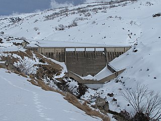
Guthega Dam is concrete gravity dam with an uncontrolled spillway across the Snowy River in the Snowy Mountains of New South Wales, Australia. The dam's main purpose is for the storage of water used in the generation of hydro-power. It is the first to be completed of the sixteen major dams of the Snowy Mountains Scheme, a vast hydroelectricity and irrigation complex constructed in south-east Australia between 1949 and 1974 and now run by Snowy Hydro.
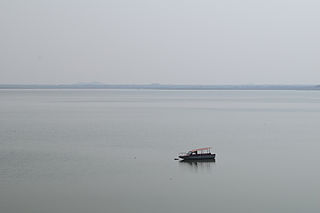
Lower Manair Dam also known as LMD was constructed across the Manair River, at Alugunur village, Thimmapur mandal, Karimnagar District, in the Indian state of Telangana during 1974 to 1985. It provides irrigation to a gross command area of 163,000 hectares.

Fitzroy Falls Dam in New South Wales, Australia, is part of the Shoalhaven Scheme, completed in 1974. It consists of four separate earth and rockfill embankments located on the Yarrunga Creek upstream of Fitzroy Falls and about 16 kilometres (9.9 mi) southeast of Moss Vale. The main embankment of 760 cubic metres (27,000 cu ft) is 14 metres (46 ft) high and 1,530 metres (5,020 ft) in length. At 100% capacity, the dam wall holds back approximately 9,950 megalitres of water, creating the impounded Fitzroy Falls Reservoir, which has a surface area of 522 hectares, drawn from a catchment area of 31 square kilometres (12 sq mi). The spillway has a discharge capacity of 516 cubic metres per second (18,200 cu ft/s).

Wingecarribee Dam, completed in 1974 as part of the Shoalhaven Scheme, is an earth and rockfill embankment dam structure located on the Wingecarribee River about 15 kilometres (9.3 mi) southeast of Bowral in New South Wales, Australia. The embankment of 573 cubic metres (20,200 cu ft) is 19 metres (62 ft) high and 1,140 metres (3,740 ft) in length. At 100% capacity, the dam wall holds back approximately 25,875 megalitres and creates the impounded reservoir of Wingecarribee Reservoir that has a surface area of 625 hectares, drawn from a catchment area of 40 square kilometres (15 sq mi). The spillway has a discharge capacity of 520 cubic metres per second (18,000 cu ft/s). Wingecarribee Reservoir lost around 9,000 megalitres of storage capacity as a result of the inflow of peat from the Wingecarribee Swamp collapse in August 1998. The original storage capacity was 34,500 megalitres.

The Vorotan Cascade, or the ContourGlobal™ Hydro Cascade, is a cascade on the Vorotan River in Syunik Province, Armenia. It was built to produce hydroelectric power and provide irrigation water. The Vorotan Cascade consists of three hydroelectric power plants and five reservoirs with a combined installed capacity of 404.2 MW. It is one of the main power generation complexes in Armenia.

The Kanjirapuzha Dam, a masonry earth dam built for providing irrigation to a Cultural Command Area (CCA) of 9,713 hectares, is located in the Palakkad district in the Indian state of Kerala. The reservoir, which has three islands within it, also has an established commercial fisheries development programme operated by the Fisheries Department.


