
Wernigerode is a town in the district of Harz, Saxony-Anhalt, Germany. Until 2007, it was the capital of the district of Wernigerode. Its population was 32,181 in 2020.

The Harz, also called the Harz Mountains, is a highland area in northern Germany. It has the highest elevations for that region, and its rugged terrain extends across parts of Lower Saxony, Saxony-Anhalt, and Thuringia. The name Harz derives from the Middle High German word Hardt or Hart. The name Hercynia derives from a Celtic name and could refer to other mountain forests, but has also been applied to the geology of the Harz. The Brocken is the highest summit in the Harz with an elevation of 1,141.1 metres (3,744 ft) above sea level. The Wurmberg is the highest peak located entirely within the state of Lower Saxony.

The Province of Saxony, also known as Prussian Saxony, was a province of the Kingdom of Prussia and later the Free State of Prussia from 1816 until 1944. Its capital was Magdeburg.

Nordhausen is a city in Thuringia, Germany. It is the capital of the Nordhausen district and the urban centre of northern Thuringia and the southern Harz region; its population is 42,000. Nordhausen is located approximately 60 km north of Erfurt, 80 km west of Halle, 85 km south of Braunschweig and 60 km east of Göttingen.
Ilfeld is a village and a former municipality in the district of Nordhausen, in Thuringia, Germany. It is situated at the south foot of the Harz, at the entrance to the Bährethal, 8 miles (13 km) north from Nordhausen by the railway to Wernigerode. Since 1 January 2012, it has been part of the municipality of Harztor.

Stolberg is a town and a former municipality in the district of Mansfeld-Südharz, in the German State of Saxony-Anhalt, Germany. It is situated in the southern part of the Harz mountains, about 27 kilometres (17 mi) west of Sangerhausen, and 13 km (8.1 mi) northeast of Nordhausen. Since 1 September 2010, it has been part of the municipality of Südharz.

Benneckenstein is a town in the district of Harz, in Saxony-Anhalt, Germany. Since 1 January 2010, it has been part of the town of Oberharz am Brocken. Benneckenstein is in the eastern Harz, 14 km southeast of Braunlage, and 24 km south of Wernigerode. Its population is 1,698 (2021).
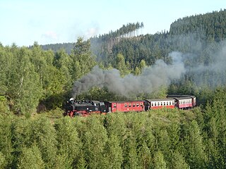
The Harz Railway or Trans-Harz Railway was formerly the main line of the Harz Narrow Gauge Railways and runs north to south right across the Harz Mountains from Wernigerode to Nordhausen. However, the tourist attraction of the Brocken, the highest mountain in the Harz, is so great that the Brocken Railway is effectively the main line today. The Trans-Harz Railway joins up with the Selke Valley Railway to Quedlinburg at Eisfelder Talmühle where all trains are organised to make good connections.

Drübeck is a village and a former municipality in the district of Harz, in Saxony-Anhalt, Germany. Since 1 July 2009, it is part of the town Ilsenburg.
Stapelburg is a village and a former municipality in the district of Harz, in Saxony-Anhalt, Germany.
The County of Stolberg was a county of the Holy Roman Empire located in the Harz mountain range in present-day Saxony-Anhalt, Germany. It was ruled by a branch of the House of Stolberg.

The County of Wernigerode was a state of the Holy Roman Empire which arose in the Harzgau region of the former Duchy of Saxony, at the northern foot of the Harz mountain range. The comital residence was at Wernigerode, now part of Saxony-Anhalt, Germany. The county was ruled by a branch of the House of Stolberg from 1429 until its mediatization to the Kingdom of Prussia in 1806. Nevertheless, the county remained in existence - with one short interruption - until the dissolution of the Kingdom of Prussia in 1918.

The Poppenberg is a tree-covered hill east of Ilfeld in the Harz mountains of Germany, at an elevation of 601 metres. Since 1897, there has been a 33-metre-high (108 ft) steel lattice observation tower on the summit. The tower was built by the Nordhausen branch of the Harz Club and was named after Otto, Prince of Stolberg-Wernigerode. In good weather, it has an extensive view over the South Harz, the Goldene Aue and the Kyffhäuser.
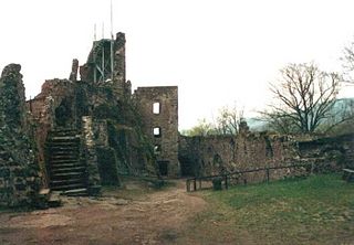
Hohnstein Castle is one of the largest and best-preserved castle ruins in Germany and is located near Neustadt in the vicinity of Nordhausen in Thuringia.

The Helme is a river in central Germany that is about 65 kilometres (40 mi) long and which forms a left-hand, western tributary of the Unstrut in the states of Thuringia and Saxony-Anhalt.

Christian Ernest, Count of Stolberg-Wernigerode, was a German politician and a member of the House of Stolberg. From 1710 to 1771 he governed County of Wernigerode in the Harz mountains, which in 1714 became a dependency of Brandenburg-Prussia.

The House of Stolberg is an old and large German dynasty of the former Holy Roman Empire's high aristocracy. Members of the family held the title of Fürst and Graf. They played a significant role in feudal Germany's history and, as a mediatized dynasty, enjoyed princely privileges until the collapse of the German Empire in 1918. The house has numerous branches.

The Scharfenstein is a mountain, 697.6 m above sea level (NN) high, in the Harz Mountains of Germany, near Ilsenburg in the district of Harz in Saxony-Anhalt. It is part of the Harz National Park.
The Barony of Bilstein was a dynastic lordship with extensive estates in the region of the present German states of Hesse and Thuringia and a territory of the Holy Roman Empire.


