Arghakhanchi is one of the districts of Province No. 5 in Nepal. The district headquarter is Sandhikharka. The district covers an area of 1,193 km2 (461 sq mi) and has a population (2011) of 197,632. Its neighboring districts are Palpa in the east, Gulmi in the north, Kapilvastu District in the south and Pyuthan in the west.

Baglung District, a part of Gandaki Pradesh, is one of the seventy-seven districts of Nepal. The district, with Baglung as its district headquarters, covers an area of 1,784 km2 (689 sq mi) and has a population (2011) of 268,613.
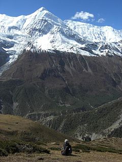
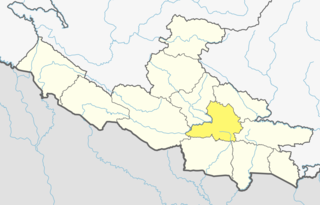
Manang District (Nepali: मनाङ जिल्ला Listen , a part of Gandaki Pradesh, is one of the seventy-seven districts of Nepal. The district, with Chame as its district headquarters, covers an area of 2,246 km2 and had a population of 6,538.

Parbat District (Nepali: पर्वत जिल्लाListen , is a hilly area of Nepal. It is a part of Gandaki Pradesh and one of the seventy-seven districts of Nepal, a landlocked country of South Asia. The district, with Kusma as its district headquarters, covers an area of 494 km2 and has a population of 157,826. It is the fourth smallest district of Nepal with 47 VDCs currently. It is mainly famous for the Gupteshwar Cave, which is visited by thousands of pilgrims during Shivaratri. Patheshwari Temple is the most famous temple of Kushma located at Katuwa Chaupari of Kushma-09. Patheshwori Mandir has many sub-temples inside like Ram Janaki Mandir, Bhagwati, Devi, Hanuman, and others. Alapeshwar cave is a famous cave in this district. It is also noted for the Dahere Deurali Temple, which is visited by thousands of pilgrims during Balachaturdanshai. Kamadhenu Mandir is another famous temple of Parbat district which is located in Khurkot development committee. Recently the Modi hydro project of 10 M.W. has been constructed in this district. Parbat's biggest playground lies in Phalewas village named Majhi Chour and Indra Chour.

Sarlahi, a part of Province No. 2, is one of the seventy-seven districts of Nepal. According to new laws, combination of more than 2 or 4 villages makes a municipality, which covers an area of 1,259 km2 (486 sq mi) and had a population of 635,701 in 2001 and 769,729 in 2011.

Budhabare, more specifically Hadiya Budhabare, is a village and former Village Development Committee that is now part of Buddhashanti Rural Municipality in Jhapa district of Province No. 1 in south-eastern Nepal. The latest official data, 2011 Nepal Census, puts the total population of the VDC at 22,936. Owing to this average population size, the VDC has been divided into nine wards.
Jitpur is a town and Village Development Committee in Ilam District in the Mechi Zone of eastern Nepal. At the time of the 1991 Nepal census it had a population of 5,454 persons residing in 989 individual households.

Sulubung is a Village Development Committee in Ilam District in the Mechi Zone of eastern Nepal. At the time of the 1991 Nepal census it had a population of 3,470. Maipokhari, one of the major tourist and religious place of Nepal lies here. A company named Hesty Kiwi Private Limited has been established in this region which had helped to popularize this village with the plantation of kiwifruit. It is about 15 km from Ilam Bazaar. It is a hilly area having cold climate and mainly tea production is the income of most of the people here.
Katuwa Chaupari is a market center in Kushma Municipality in Gyandi of Parbat District in the Dhawalagiri Zone of central Nepal. The formerly Village Development committee was annexed to form the municipality since 18 May 2014. At the time of the 1991 Nepal census it had a population of 1838 people living in 361 individual households.

Anbu Khaireni, also Aanbu Khaireni, Aanboo Khaireni or Anbukhaireni, is a Municipality in Tanahu District in the Gandaki Zone of central Nepal established in 2015. At the time of the 1991 Nepal census it had a population of 11.450 people living in 2234 individual households. In the census of 2011 the municipality has 16.382 inhabitants.
Parsa is a rural municipality in Sarlahi District, a part of Province No. 2 in Nepal. It is situated 10 km East from Malangwa which is headquarter of Sarlahi. It was formed in 2016 occupying current 6 sections (wards) from previous 6 former VDCs. It occupies an area of 23.12 km2 with a total population of 21,650. The major language spoken in the rural municipality are Maithili and Bajjika.
Bhiman is a town in Kamalamai Municipality Ward no. 11 in Sindhuli District in the Janakpur Zone of south-eastern Nepal. At the time of the 1991 Nepal census it had a population of 7609 people living in 1389 individual households.
Hawaku is a village development committee in the Himalayas of Terhathum District in the Kosi Zone of eastern Nepal. At the time of the 1991 Nepal census it had a population of 3390 people living in 589 individual households. A higher secondary school is the only school of Hwaku. It is bordered with IWa, Sakranti, Nighuradin (Taplejung) and Amarpur (Panchthar). The Tamor river lies to the east Hwaku making it an area suitable for cultivation.
Maunabudhuk is a village development committee in Dhankuta District in the Kosi Zone of eastern Nepal. At the time of the 1991 Nepal census it had a population of 2372 people living in 440 individual households.
Raja Rani is a village development committee in Dhankuta District in the Koshi Zone of eastern Nepal. At the time of the 1991 Nepal census it had a population of 2567 people living in 491 individual households.
Birendranagar is a village development committee (VDC) in Chitwan District in the Narayani Zone of southern Nepal. At the time of the 1991 Nepal census it had a population of 10,482 people living in 1932 individual households. However, the population now increased by more than three times and reached about 30 thousand. This VDC is located in about 150 km from Kathmandu in the south west direction from the capitalcity of Nepal, i.e. Kathmandu. Chitwan is the district where it falls in the eastern part, which is surrounded by six VDCs: Khairahani, Chainpur, Siddhi, Korak, Bhandara and Kathar. It is about two times bigger than Bhandara and Khairahani and similar in area as Chainpur. The village is divided into nine wards, which are further subdivided into one to seven groups.
Gardi was a village development committee in Chitwan District in Bagmati Pradesh of mid-southern Nepal before merging into Madi Municipality. At the time of the 1991 Nepal census it had a population of 9544 people living in 1620 individual households. Sitalpur (सितलपुर) is the largest village inside Gardi.
Amaibariyati is a village development committee in Morang District in the Kosi Zone of south-eastern Nepal. At the time of the 1991 Nepal census it had a population of 5473 people living in 1133 individual households.
Bhaudaha is a village development committee in Morang District in the Kosi Zone of south-eastern Nepal. At the time of the 1991 Nepal census it had a population of 4743 people living in 876 individual households.
Ramite Khola is a village development committee in Morang District in the Kosi Zone of south-eastern Nepal. At the time of the 1991 Nepal census it had a population of 2645 people living in 452 individual households.
Sorabhag is developing village development committee which is surrounded by Cheka Khola from eastern side whereas Gadiya Khola from western side.
Karsiya Lies by the side of Gadiya Khola.Karsiya is nearly famous place in Sorabhag V.D.C .Karsiya is only big market which helps you to shop your goods.
There's a government school named as Sharada Higher Secondary School Lies at karsiya Bazar.
