
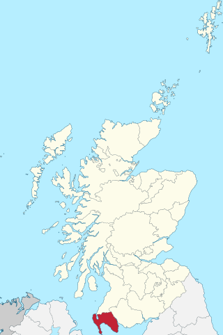
Dumfries and Galloway is one of the 32 unitary council areas of Scotland, located in the western part of the Southern Uplands. It is bordered by East Ayrshire, South Ayrshire, and South Lanarkshire to the north; Scottish Borders to the north-east; the English county of Cumbria, the Solway Firth, and the Irish Sea to the south, and the North Channel to the west. The administrative centre and largest settlement is the town of Dumfries. The second largest town is Stranraer, located 76 miles (122 km) to the west of Dumfries on the North Channel coast.
Wigtownshire or the County of Wigtown is one of the historic counties of Scotland, covering an area in the south-west of the country. Until 1975, Wigtownshire was an administrative county used for local government. Since 1975 the area has formed part of Dumfries and Galloway for local government purposes. Wigtownshire continues to be used as a territory for land registration, being a registration county. The historic county is all within the slightly larger Wigtown Area, which is one of the lieutenancy areas of Scotland and was used in local government as the Wigtown District from 1975 to 1996.

New Galloway is a town in the historical county of Kirkcudbrightshire in Dumfries and Galloway. It lies on the west side of the valley of the Water of Ken, 1 mile north of the end of Loch Ken. Before the local government reform of 1975, it was the smallest Royal Burgh in Scotland.

Dumfries and Galloway is a constituency in Scotland represented in the House of Commons of the UK Parliament by John Cooper of the Scottish Conservatives since the 2024 general election. It was first contested in the 2005 general election, replacing Galloway and Upper Nithsdale and part of Dumfries. Like all British constituencies, it elects one Member of Parliament (MP) by the first-past-the-post system of election. Despite its name, it does not cover the whole of the Dumfries and Galloway council area.

Buittle is an ecclesiastical and civil parish in Dumfries and Galloway, southwest Scotland, in the traditional county of Kirkcudbrightshire. It lies to the west of the Urr Water, between Dalbeattie and Castle Douglas, and extends from Haugh of Urr in the north to Almorness Point on the Solway Firth in the south. The main settlement is the small village of Palnackie.
Anwoth is a settlement near the Solway Firth in the historic county of Kirkcudbrightshire, southwest Scotland, within a parish of the same name in the Vale of Fleet, Dumfries and Galloway. Anwoth lies a mile (1.5 km) to the west of Gatehouse of Fleet.

Clan MacDowall or MacDouall is a Lowlands Scottish clan.

Clan Hannay is a Lowland Scottish clan.
Sorbie is a small village in Wigtownshire, Machars, within the administration area of Dumfries and Galloway Council, Scotland.

The Motte of Urr is the remains of a 12th-century motte-and-bailey castle located near the Haugh of Urr in Dumfries and Galloway, Scotland.
Glasserton is a civil parish in Dumfries and Galloway, south-west Scotland. It is on the Machars peninsula, in the traditional county of Wigtownshire. The parish is about 8 miles (13 km) in length, varying in breadth from 1 to 3 miles, and contains 13,477 acres (54.54 km2).
Eaglesfield is a village in south east Dumfriesshire in the local authority area of Dumfries and Galloway, Scotland.

Edingham Castle is a late 16th-century tower house situated near Dalbeattie, Dumfries and Galloway. It is the remains of an early tower house built for the Livingstones of Little Airds. It is near Edingham Munitions Factory and is a scheduled ancient monument.

Closeburn is a village and civil parish in Dumfries and Galloway, Scotland. The village is on the A76 road 2+1⁄2 miles (4 km) south of Thornhill. In the 2001 census, Closeburn had a population of 1,119. Closeburn is recorded as Killosbern in 1185. The first element of the name is Gaelic cill 'cell or church'. The second element is a saint's name, but none has definitely been identified.

Boreland is a village in Dumfries and Galloway, Scotland, which is located in Dryfesdale about 7 miles north of Lockerbie on the B723 road to Eskdalemuir. The village is bordered by the Dryfe Water to the north, whilst the Boreland Burn flows to the south of the village which is a tributary of the Dryfe Water. Next to the Dryfe are the remains of Gillesbie Tower which was home to one of the Border Reiver clans, the Grahams. This tower, dating back to the 15th century, was a stronghold of the Grahams of Gillesbie. The area surrounding Boreland has many other significant historical remains, with some dating back to the Iron Age.
Glencairn is an ecclesiastical and civil parish in Dumfries and Galloway, Scotland.
Bonshaw Tower is an oblong tower house, probably dating from the mid-16th century, one mile south of Kirtlebridge, Dumfries and Galloway, Scotland, above the Kirtle Water. It is adjacent to a 19th-century mansion. The tower was one of a number of structures built along the Scottish border in the 1500s as protection against incursions by the English.
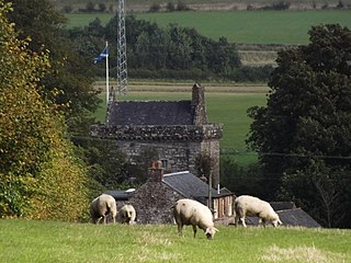
Mains of Penninghame Platform railway station (NX410617) was a halt on the Wigtownshire Railway branch line, from Newton Stewart to Whithorn, of the Portpatrick and Wigtownshire Joint Railway. It served a rural area of farms, including the large Mains of Penninghame and the nearby Clachan and old Kirk of Penninghame in the Parish of Penninghame, old Wigtownshire.

Galdenoch Castle is a tower house near the Scottish village of Leswalt in the Council Area Dumfries and Galloway. The ruin is listed as a Scheduled Monument.
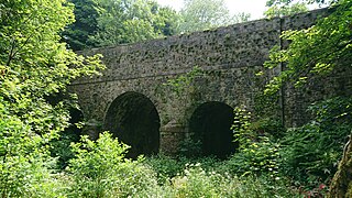
Kirkdale Bridge is a bridge over the Kirkdale Burn in the parish of Kirkmabreck, between Gatehouse of Fleet and Creetown in Dumfries and Galloway, Scotland. It was built for Sir Samuel Hannay, based on designs drawn up by Robert Adam, but the execution was much simpler than Adam had originally envisaged, probably to reduce the construction costs.

