
Galdenoch Castle is a tower house near the Scottish village of Leswalt in the Council Area Dumfries and Galloway . The ruin is listed as a Scheduled Monument. [1]
Galdenoch Castle is a tower house near the Scottish village of Leswalt in the Council Area Dumfries and Galloway . The ruin is listed as a Scheduled Monument. [1]
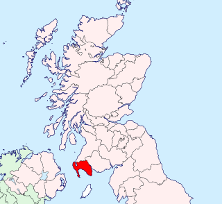
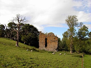
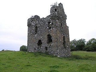
Galdenoch Castle is isolated on the Rhins of Galloway about 4.5 mi (7.2 km) west of Leswalt. A badge shows the year of construction 1547 and the initials GA. Probably continued the construction for Gilbert Agnew of Lochnaw until 1570. The tower has an L-shaped floor plan. The quarry stone masonry is up to 1.15 m (3 ft 9 in) thick. The interiors have a floor area of [ clarification needed ] with a length of 6.95 m (22.8 ft) and a width of 4.4 m (14 ft). The three-storey building was described as a ruin at the beginning of the 20th century. The walls are partially preserved up to a height of about 10.5 meters, in particular, the western flank is badly damaged. [2]
The entrance portal with relief arch is located inside the building. There are different window openings with falls received. On the southwest side a tourer with three windows cantilevered out. From the once final pitched roof, the gables are preserved. The lowest floor is worked as a stone vault . A narrow spiral staircase in the shorter building wing leads to the upper floors. [2]
Wigtownshire or the County of Wigtown is a historic county, registration county and lieutenancy area in south-west Scotland. It is popularly known as and referred to as The Shire. Until 1975, Wigtownshire was one of the administrative counties used for local government purposes, and is now administered as part of the council area of Dumfries and Galloway. As a lieutenancy area, Wigtownshire has its own Lord Lieutenant, currently John Alexander Ross. In the 19th century, it was also called West Galloway. The county town was historically Wigtown, with the administrative centre moving to Stranraer, the largest town, on the creation of a county council in 1890.

Doune Castle is a medieval stronghold near the village of Doune, in the Stirling district of central Scotland. The castle is sited on a wooded bend where the Ardoch Burn flows into the River Teith. It lies 8 miles northwest of Stirling, where the Teith flows into the River Forth. Upstream, 8 miles further northwest, the town of Callander lies at the edge of the Trossachs, on the fringe of the Scottish Highlands.
Craigmillar Castle is a ruined medieval castle in Edinburgh, Scotland. It is three miles (4.8 km) south-east of the city centre, on a low hill to the south of the modern suburb of Craigmillar. The Preston family of Craigmillar, the local feudal barons, began building the castle in the late 14th century and building works continued through the 15th and 16th centuries. In 1660, the castle was sold to Sir John Gilmour, Lord President of the Court of Session, who breathed new life into the ageing castle. The Gilmours left Craigmillar in the 18th century for a more modern residence, nearby Inch House, and the castle fell into ruin. It is now in the care of Historic Environment Scotland as a scheduled monument, and is open to the public.

Dunstaffnage Castle is a partially ruined castle in Argyll and Bute, western Scotland. It lies 3 miles (5 km) NNE of Oban, situated on a platform of conglomerate rock on a promontory at the south-west of the entrance to Loch Etive, and is surrounded on three sides by the sea. The castle and the nearby chapel ruin have been a Historic Scotland property since 1958. Both are Scheduled Ancient Monuments.

Threave Castle is situated on an island in the River Dee, 2.5 kilometres (1.6 mi) west of Castle Douglas in the historical county of Kirkcudbrightshire in the Dumfries and Galloway region of Scotland.

Orchardton Tower is a ruined tower house in Kirkcudbrightshire, Dumfries and Galloway, Scotland. It is located four miles south of Dalbeattie, and one mile south of Palnackie, in Buittle parish. It is remarkable as the only cylindrical tower house in Scotland. Orchardton Tower is in the care of Historic Environment Scotland as a Scheduled Ancient Monument.

MacLellan's Castle in the town of Kirkcudbright, in Galloway, Scotland, was built in the late 16th century. It stands in the centre of Kirkcudbright, on the south side of the River Dee which flows into the Solway Firth. The L-plan castle was the residence of the MacLellan family from whom it derived its name. The family sold the castle in 1752, and from 1782 to 1912 it was held by the Earls of Selkirk. Today, the site is curated by Historic Environment Scotland.

Carsluith Castle is a ruined tower house, dating largely to the 16th century. It is located beside Wigtown Bay in the historical county of Kirkcudbrightshire in Galloway, Scotland, around 4.8 kilometres (3.0 mi) south east of Creetown.

Greenknowe Tower is a 16th-century tower house, located just west of the village of Gordon, in the Scottish Borders. Although a roofless ruin, the stonework of the tower is well preserved, and represents a fine example of a later tower house, built more as a residence rather than as a place of defence. The building is located at NT639428, beside the A6105 road. It is a Scheduled Ancient Monument, and is in the care of Historic Scotland.

Ballumbie is a residential area on the north-east edge of Dundee, Scotland. The area was formerly an estate centred on Ballumbie Castle, a mid-16th-century fortification, which was followed by the 19th-century Ballumbie House. There is also a golf course surrounded by a medieval wall and the site of a late medieval parish church. The castle and house are located just outside the City of Dundee, in Angus.

Barholm Castle is a tower house located 5 miles (8.0 km) south-west of Gatehouse of Fleet, in Kirkcudbrightshire, Galloway, Scotland. The tower dates back to the late 15th century, and it was a stronghold of a branch of the MacCulloch family. The present form of the castle dates from rebuilding in the 16th or 17th century, and in the early 2000s it was restored from a roofless state to residential use. The tower is sometimes identified with the fictional Ellangowan, in Sir Walter Scott's Guy Mannering.

Borve Castle, also known as Castle Wearie, and Caisteal Bhuirgh in Scottish Gaelic, is a ruined 14th-century tower house, located at the south-west of the island of Benbecula, in the Western Isles of Scotland. The castle was designated as a Scheduled Monument in 1993.
Nether Horsburgh Castle is a ruined tower house near Cardrona, in the Scottish Borders, in the former county of Peebleshire. It is situated at the back of a farmstead, 3.5 miles (5.6 km) southwest of the market town of Peebles, at grid reference grid reference NT304396, on the A72 road. Access may be gained by permission from the adjoining farmstead, Nether Horsburgh Farm.
Leswalt is a village and civil parish in Dumfries and Galloway, south-west Scotland. It lies between Portpatrick and Stranraer in the Rhins of Galloway, part of the traditional county of Wigtownshire. The parish covers around 8 square miles (21 km2).

Mauchline Castle, also known as Abbot Hunter's Tower, is a rectangular tower house dating from the fifteenth century, in Mauchline, East Ayrshire, Scotland. The tower once formed part of a group of monastic buildings associated with Melrose Abbey, and today is a category A listed building.
Findochty Castle is a ruined 16th century L-plan tower house, near Findochty, Moray, Scotland, about 2.5 miles (4.0 km) north-east of Buckie, and about 0.25 miles (0.4 km) from the sea to the north.

Lochwood Tower, also known as Lochwood Castle, is a ruined 16th-century L-plan tower house situated in Annandale about 6 miles (9.7 km) south of the town of Moffat in the modern county of Dumfries and Galloway, Scotland. It was the seat of the Clan Johnstone.
Rusco Tower, sometimes called Rusco Castle, is a tower house near Gatehouse of Fleet in Dumfries and Galloway, Scotland. Built around 1500 for Mariota Carson and her husband Robert Gordon, on lands given to them by her father, it was used to incarcerate a number of the Gordons' rivals in the 16th century. After Robert Gordon died and Carson remarried, their eldest son James Gordon seized the tower and imprisoned his mother, fearing that she would make it over to her new husband, Thomas Maclellan of Bombie. Gordon went on to kill Maclellan on the High Street in Edinburgh, while a court case intended to settle the matter was ongoing.
Plunton Castle is a ruined L-plan tower house between Kirkandrews and Gatehouse of Fleet in Dumfries and Galloway, Scotland. Built around 1575 for the Lennoxes of Plunton, it passed by marriage to the Murrays of Broughton in the late 17th century. It was still inhabited in 1684, when it was described by Reverend Symson in his Large Description of Galloway as "a good strong house", but by 1838, when it was painted by George Colomb, it had been abandoned and had fallen into a ruinous condition.

Dowhill Castle is a ruined castle in Perth and Kinross, Scotland. Sited on a hill near Loch Leven, the oldest part of the castle was built in around 1500 as a tower house. The main structure was extended in around 1600 with additional living space, as well as a tower and turret. The castle had a fortified courtyard (barmkin) to the north with a separate tower. There were probably four storeys but only two still survive.
