
Parking is the act of stopping and disengaging a vehicle and usually leaving it unoccupied. Parking on one or both sides of a road is often permitted, though sometimes with restrictions. Some buildings have parking facilities for use of the buildings' users. Countries and local governments have rules for design and use of parking spaces.
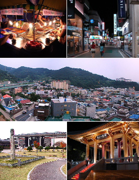
Gwangju, formerly romanized as Kwangju, is South Korea's sixth-largest metropolis. It is a designated metropolitan city under the direct control of the central government's Home Minister. The city was also the capital of South Jeolla Province Province until the provincial office moved to the southern village of Namak in Muan County in 2005 because Gwangju was promoted to a metropolitan city and was independent of South Jeolla Province.
The Gwangju–Daegu Expressway(Korean: 광주대구 고속도로) formerly 88 Olympic Expressway(88올림픽 고속도로; Pal-pal Olimpik Gosokdoro) is a freeway in South Korea, connecting Gwangju to Daegu (175.3 km). It was only expressway that has 2 lanes in South Korea.
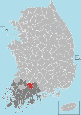
Gokseong County is a county in Jeollanam-do, South Korea and the least densely populated subdivision of the province.
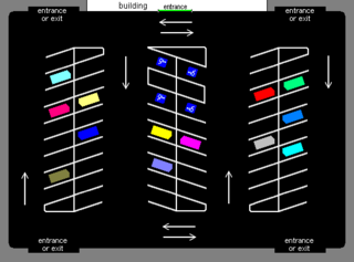
A parking lot or car park, also known as a car lot, is a cleared area intended for parking vehicles. The term usually refers to an area dedicated only for parking, with a durable or semi-durable surface. In most jurisdictions where cars are the dominant mode of transportation, parking lots are a major feature of cities and suburban areas. Shopping malls, sports stadiums, and other similar venues often have immense parking lots.

The Gwangju Uprising, known in Korean as May 18, was a series of student-led demonstrations that took place in Gwangju, South Korea, in May 1980, against the dictatorship of Chun Doo-hwan. The uprising was violently suppressed by the South Korean military with the approval and logistical support of the United States under the Carter administration, which feared the uprising might spread to other cities and tempt North Korea to interfere. The uprising is also known as the May 18 Gwangju Democratization Movement, the Gwangju Democratization Struggle, the May 18 Democratic Uprising or the Gwangju Uprising in South Korea.

The Gyeongjeon Line (Korean: 경전선) is a railway line serving South Gyeongsang and South Jeolla Provinces in South Korea. It covers a total of 300.6 km, from Samnangjin Station in Miryang, South Gyeongsang, to Gwangju Songjeong Station in Gwangju, South Jeolla.

Seongnam is the fourth largest city in South Korea's Gyeonggi Province after Suwon and the 10th largest city in the country. Its population is approximately one million. It consists of three administrative districts: Bundang District, Jungwon District, and Sujeong District.

Gwangju Airport is an airport in Gwangju, South Korea and is managed by the Korea Airports Corporation. In 2018, 1,986,125 passengers used the airport. This airport is planned to close when Muan International Airport becomes more established. Because Gwangju Airport is sharing with military, taking photograph or video of apron, runway and military facility is strictly prohibited.

Gwangju Metro Line 1 is a rapid transit line in Gwangju, South Korea, operated by the Gwangju Metropolitan Rapid Transit Corporation. It connects Nokdong station in Dong-gu at its eastern terminus to Pyeongdong station in Gwangsan-gu in the west, via the central business district and Gwangju Airport. On maps, it is designated by teal.

Emerson is an active commuter railroad station in the borough of Emerson, Bergen County, New Jersey. The station, serviced by trains of the Pascack Valley Line from Spring Valley in Rockland County, New York to Hoboken Terminal in Hudson County, New Jersey, is located at the intersection of Kinderkamack Road and Linwood Avenue in Emerson. The next station to the north is Westwood while the next to the south is Oradell. The station has a single track and single low-level side platform along Kinderkamack Road, without handicap accessibility under the Americans with Disabilities Act of 1990.
The Abandoned Pennsylvania Turnpike is the common name of a 13-mile (21 km) stretch of the Pennsylvania Turnpike that was bypassed in 1968 when a modern stretch opened to ease traffic congestion in the tunnels. In this case, the Sideling Hill Tunnel and Rays Hill Tunnel were bypassed, as was one of the Turnpike's travel plazas. The bypass is located just east of the heavily congested Breezewood interchange for Interstate 70 (I-70) eastbound at what is now I-76 exit 161. The section of the turnpike was at one time part of the South Pennsylvania Railroad.
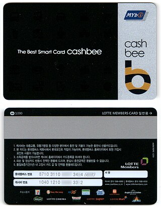
The Mybi (Korean: 마이비) card is a kind of contactless smartcard used in South Korea. This system was introduced in 2000 as a new fare collection system for the Busan area. now discontinued. see EZL. Lotte started new name and united fare card.
Dedham Corporate Center station is an MBTA Commuter Rail station in Dedham, Massachusetts. It serves the Franklin/Foxboro Line, and is located just off exit 28 of Interstate 95/Route 128. It serves mostly as a park-and-ride location. The station consists of two platforms serving the Franklin/Foxboro Line's two tracks. Previous stations named Dedham Junction and Rust Craft (1955–1977) were located near the modern site.

GwangjuSongjeong Station is a station in Gwangju, South Korea. It is on the national high-speed KTX railway network, 341 km south of Yongsan Station.
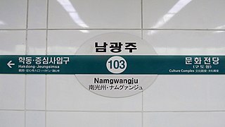
Namgwangju station is a station on Gwangju Metro Line 1, located at Hak-dong 994 in Dong-gu, Gwangju, South Korea. It opened for service on April 28, 2004.

Road signs in South Korea are regulated by the Korean Road Traffic Authority.

Children's Grand Park (Korean: 어린이대공원) or Seoul Children's Grand Park is a park complex in Gwangjin District, Seoul, South Korea. Facilities at Children's Grand Park include hills and hiking trails, Zoo, garden, and an amusement park. Children's Grand Park is a leisure facility for families, offering a botanical garden, amusement facilities, and diverse performance events. The facility first opened on Children's Day, 1975.

Perungudi is a railway station on the Chennai MRTS. It serves the neighbourhood of Perungudi, including localities such as Indira Nagar, Park Avenue and Tansi Nagar. It is located 1.3 km (0.81 mi) from the Perungudi Lake.

Geumnamno 5(o)-ga station (Korean: 금남로5가역) is a station of Gwangju Metro Line 1 in Buk-dong, Buk District, Gwangju, South Korea.
