South Dakota Highway 75

Last updated

SD 75.svg

Highway 75

South Dakota Highway 75 map 1.png

Route of SD 75 (in red)
Route information
Defined by SDCL §31-4-177
Maintained by SDDOT
Length 29.352 mi [1] (47.237 km)
Existed 1976 – present
Major junctions
South endSD 20.svg SD 20 west of Bison
North endND-8 (2015).svg ND 8 south of Hettinger, N.D.
Location
Counties Perkins
Highway system
  • South Dakota Highways
SD 73.svg SD 73 SD 79 SD 79.svg

South Dakota Highway 75 (SD 75) is a state route located in northwest South Dakota. The southern terminus is at South Dakota Highway 20 west of Bison, and the route runs northerly to the North Dakota border, becoming North Dakota Highway 8. It is 28 miles (45 kilometers) in length.

South Dakota State of the United States of America

South Dakota is a U.S. state in the Midwestern region of the United States. It is named after the Lakota and Dakota Sioux Native American tribes, who compose a large portion of the population and historically dominated the territory. South Dakota is the seventeenth largest by area, but the fifth smallest by population and the 5th least densely populated of the 50 United States. As the southern part of the former Dakota Territory, South Dakota became a state on November 2, 1889, simultaneously with North Dakota. Pierre is the state capital and Sioux Falls, with a population of about 183,200, is South Dakota's largest city.

South Dakota Highway 20 highway in South Dakota

South Dakota Highway 20 (SD 20) is a 385.079-mile-long (619.725 km) state highway in the northern part of the U.S. state of South Dakota. It connects the Montana state line, west-southwest of Camp Crook, with the Minnesota state line, east-southeast of Revillo, via Buffalo, Bison, Timber Lake, Mobridge, Selby, and Watertown. From Mobridge to the Walworth–Potter county line, this highway is part of the Lewis and Clark Trail. From about Timber Lake to just west of Mobridge, this highway is part of the Native American Scenic Byway. From the Montana state line to Camp Crook, the highway is a dirt road.

Bison, South Dakota Town in South Dakota, United States

Bison is a town in and the county seat of Perkins County, South Dakota, United States. The population was 333 at the 2010 census.

Contents

History

This is the third use of the South Dakota 75 designation.

The first South Dakota 75 was designated around 1934, in southeast Shannon County. It was originally 10 miles (16 km) long, with its northern terminus at U.S. Highway 18. When that route was realigned southward, SD 75 was shortened to 3 miles (4.8 km). This configuration remained in place until 1976, when it was redesignated as South Dakota Highway 391.

South Dakota Highway 391 highway in South Dakota

South Dakota Highway 391 (SD 391) is a 3.362-mile-long (5.411 km) state highway in the southwestern part of the U.S. state of South Dakota. It travels from Nebraska Highway 27 (N-27) at the Nebraska state line, southeast of Denby, to U.S. Route 18 (US 18) east-southeast of Denby. The highway is located entirely within Oglala Lakota County and in the Pine Ridge Indian Reservation. It is maintained by the South Dakota Department of Transportation (SDDOT), and is not part of the National Highway System.

The second use of SD 75 was implemented around 1949, in northwest South Dakota. It was located in northeast Harding County, beginning at South Dakota Highway 8 (current SD 20) and extending northward to the North Dakota border. In 1976, the SD 75 designation was moved approximately 18 miles (29 km) east onto its current alignment, where it remains today; the old segment became part of South Dakota Highway 79.

Harding County, South Dakota county in South Dakota, United States

Harding County is a county in the U.S. state of South Dakota. As of the 2010 United States Census, the population was 1,255, making it the second-least populous county in South Dakota. Its county seat is Buffalo.


South Dakota Highway 79 (SD 79) is a 209-mile-long (336 km) state highway in the U.S. state of South Dakota. It runs from Maverick Junction near the Black Hills National Forest to the North Dakota state line.

Major intersections

The entire route is in Perkins County.

Locationmi [1] kmDestinationsNotes
Scotch Cap Township 0.0000.000SD 20.svg SD 20
Grand River Township 29.35247.237ND-8 (2015).svg ND 8 northContinuation beyond North Dakota state line
1.000 mi = 1.609 km; 1.000 km = 0.621 mi

Related Research Articles

U.S. Route 81 highway in the United States

U.S. Route 81 is a major north-south highway that extends for 1220 miles in the central United States and is one of the earliest United States Numbered Highways established in 1926 by the US Department of Agriculture Bureau of Public Roads.

South Dakota Highway 44 highway in South Dakota

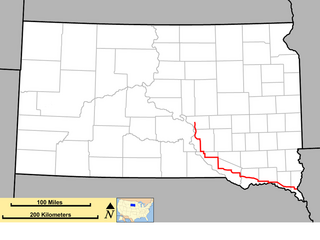
South Dakota Highway 44 (SD 44) is a state highway in southern South Dakota that runs from U.S. Route 385 (US 385) west of Rapid City to Interstate 29 (I-29) south of Sioux Falls. It is just more than 379 miles (610 km) long.

South Dakota Highway 471 highway in South Dakota

South Dakota Highway 471 (SD 471) is a 22.085-mile-long (35.542 km) state highway in the southwestern part of the U.S. state of South Dakota. It travels from SD 71 southeast of Rumford to U.S. Route 18 (US 18) in Edgemont.

South Dakota Highway 43 highway in South Dakota

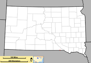
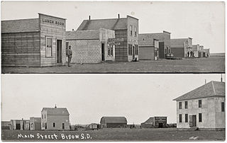
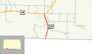
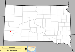
South Dakota Highway 43 (SD 43) is a 1.131-mile-long (1.820 km) state highway that exists entirely in the southern part of Gregory County in the southern part of the U.S. state of South Dakota. It begins as an extension of Nebraska Highway 11 (N-11) at the Nebraska state line south of Fairfax. It travels northwest to an intersection with U.S. Route 18 (US 18) south-southwest of the town.

South Dakota Highway 45 highway in South Dakota

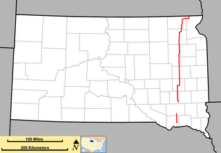
South Dakota Highway 45 is a state route that runs north to south across much of central South Dakota. The northern terminus is at the North Dakota border as a continuation of North Dakota Highway 3, and runs south to South Dakota Highway 44 at Platte. It is 198 miles (319 km) in length.

South Dakota Highway 47 highway in South Dakota

South Dakota Highway 47 is a state route that runs north to south across the central portion of South Dakota. It begins at an unnumbered highway at the North Dakota border north of Eureka, and ends at the Nebraska border, where it becomes Nebraska Highway 137. It is just under 241 miles (388 km) in length.

South Dakota Highway 48 highway in South Dakota

South Dakota Highway 48 is a short state route in the far southeast corner of the U.S. state of South Dakota. The route, which runs entirely through Union County, begins at Interstate 29 about 2.5 miles (4.0 km) west of Spink, and becomes Big Sioux River Road, formerly Iowa Highway 403, northwest of Akron, Iowa. It is 12 miles (19 km) in length.

South Dakota Highway 53 highway in South Dakota

South Dakota Highway 53 is a state route that runs north to south across south central South Dakota. It consists of two separate segments:

South Dakota Highway 25 highway in South Dakota

South Dakota Highway 25 (SD 25) is a 194.524-mile-long (313.056 km) state highway in the eastern part of the U.S. state of South Dakota. It connects Scotland, Howard, De Smet, and Webster.

South Dakota Highway 15 highway in South Dakota

South Dakota Highway 15 (SD 15) is a 67.562-mile-long (108.730 km) state highway in the northeastern part of the U.S. state of South Dakota. It connects Clear Lake, Milbank, and Wilmot.

South Dakota Highway 50 highway in South Dakota

South Dakota Highway 50 is a state route serving south central and southeast South Dakota. The current alignment begins at the junction of South Dakota Highway 34 at "Lee's Corner" east of Fort Thompson, and ends at the Iowa border near Richland, where it continues as Iowa Highway 3. It is about 212 miles (341 km) in length.

South Dakota Highway 19 highway in South Dakota

South Dakota Highway 19 (SD 19) is a 86.974-mile-long (139.971 km) state highway in the southeastern part of the U.S. state of South Dakota. It connects the Nebraska state line, south of Vermillion, with the southeastern part of the Madison area, via Viborg, Hurley, Parker, and Humboldt. SD 19 formerly entered Centerville, but was shifted to the south. Its former path was redesignated as SD 19A. Its former southern terminus was at Vermillion, but was extended when a new bridge from Nebraska opened.

South Dakota Highway 36 highway in South Dakota

South Dakota Highway 36 is an east–west state route located in southwest South Dakota. It begins at the junction of U.S. Route 16A on the eastern edge of Custer State Park, and ends at South Dakota Highway 79 just south of Hermosa. It is slightly over nine miles (14 km) in length.

South Dakota Highway 42 highway in South Dakota

South Dakota Highway 42 (SD 42) is a segmented state highway in southeastern South Dakota. The first segment is a six-mile-long (9.7 km) highway in Aurora County. The second and longest is 60 miles (97 km) long and connects Ethan and Sioux Falls. The final segment connects Sioux Falls to Iowa Highway 9 southeast of Rowena.

Interstate 29 (I-29) is a north–south Interstate Highway in the midwestern United States. In the U.S. state of South Dakota, I-29 traverses on the eastern side of the state from the Iowa border near Sioux City to the North Dakota border near New Effington. On its route, I-29 passes through western portions of Sioux Falls, the state's largest city. Interstate 229, the highway's lone auxiliary route in South Dakota, serves as a bypass around southern and eastern Sioux Falls.

South Dakota Highway 40 highway in South Dakota

South Dakota Highway 40 (SD 40) is a state highway in southwest South Dakota. The highway is just over 37 miles (60 km) long and runs from U.S. Route 16A (US 16A) in Keystone to Bureau of Indian Affairs Highway 41 in Red Shirt. The highway runs near Mount Rushmore National Memorial in Keystone, and its eastern terminus is on the Pine Ridge Indian Reservation near the edge of Badlands National Park. SD 40 was established along its current route in 1976; the SD 40 designation was originally used on a highway that is now part of SD 44.

South Dakota Highway 71 (SD 71) is a 35.59-mile-long (57.28 km) state highway in the southwestern part of the U.S. state of South Dakota. It travels from the Nebraska state line, where it continues as N-2/N-71, through the Black Hills National Forest, to U.S. Route 18 Bypass in Hot Springs. The road was originally a part of SD 87. It became SD 71 in 1962.

References

  1. 1 2 "State Highway Log" (PDF). Rapid City region: South Dakota Department of Transportation. January 2011. p. 94. Retrieved December 22, 2011.

Route map: Google

KML file (edithelp)
KML is from Wikidata