
Tampere is a city in the Pirkanmaa region, located in the western part of Finland. Tampere is the most populous inland city in the Nordic countries. It has a population of 255,066; the urban area has a population of 341,696; and the metropolitan area, also known as the Tampere sub-region, has a population of 416,653 in an area of 4,970 km2 (1,920 sq mi). Tampere is the second largest urban area and the third most populous single municipality in Finland, after the cities of Helsinki and Espoo, and the most populous Finnish city outside the Helsinki Metropolitan Area. Today, Tampere is one of the most important urban, economic and cultural centres in the entire inland region.
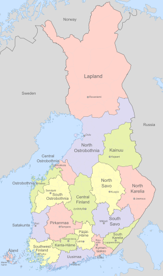
Finland is divided into 19 regions which are governed by regional councils that serve as forums of cooperation for the municipalities of each region. The councils are composed of delegates from the municipal councils. The main tasks of regional councils are regional planning, the development of enterprises, and education. Between 2004 and 2012, the regional council of Kainuu was elected via popular elections as part of an experimental regional administration.

Pirkkala is a municipality of Finland. It is located some 10 kilometres (6 mi) south-west from Tampere in the Pirkanmaa region. The municipality has a population of 20,762 and covers an area of 104.04 square kilometres (40.17 sq mi) of which 22.66 km2 (8.75 sq mi) is water. The population density is 255 inhabitants per square kilometre (660/sq mi), which makes it the most densely populated municipality in Finland that does not use the title of town or city. Pirkkala is also currently the fastest-growing municipality in the Pirkanmaa region. The municipality is unilingually Finnish.
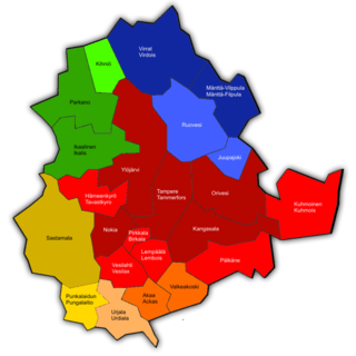
Pirkanmaa, also known as Tampere Region in government documents, is a region of Finland. It borders the regions of Satakunta, South Ostrobothnia, Central Finland, Päijät-Häme, Kanta-Häme and Southwest Finland. Most of the water area in the Kokemäki River watershed is located in the Pirkanmaa region, although Lake Vanajavesi is partly in the Kanta-Häme region. The region got its name from Pirkkala, which in the Middle Ages comprised most of present-day Pirkanmaa. Tampere is the regional center and capital of Pirkanmaa, and at the same time the largest city in the region.
Finland is divided into 69 sub-regional units. The sub-regions are formed by groups of municipalities within the 19 regions of Finland. The sub-regions represent a LAU 1 level of division used in conjunction with the Nomenclature of Territorial Units for Statistics.
The 23 municipalities of the Pirkanmaa Region in Finland are divided into five sub-regions.

Juupajoki is a municipality of Finland. It is located in the Pirkanmaa region. The municipality has a population of 1,708, which makes it the smallest municipality in Pirkanmaa in terms of population. It covers an area of 274.95 square kilometres (106.16 sq mi) of which 16.47 km2 (6.36 sq mi) is water. The population density is 6.61 inhabitants per square kilometre (17.1/sq mi). Korkeakoski is the administrative center of the municipality.

Kihniö is a municipality of Finland.

Kylmäkoski is a former municipality of Finland. It was consolidated with the town of Akaa on 1 January 2011. It was located in the Pirkanmaa region. The municipality had a population of 2,610 and covered a land area of 190.96 square kilometres (73.73 sq mi). At the end of 2011, the urban area of Kylmäkoski had 674 inhabitants. The population density was 13.67 inhabitants per square kilometre (35.4/sq mi). The municipality was unilingually Finnish.

Central Finland is a region in Finland. It borders the regions of Päijät-Häme, Pirkanmaa, South Ostrobothnia, Central Ostrobothnia, North Ostrobothnia, North Savo, and South Savo. The city of Jyväskylä is the regional centre and by far the largest city in the area.
Nastola is a former municipality of Finland. It was merged with the city of Lahti on 1 January 2016.
Ruovesi is a municipality of Finland.

Akaa is a town and a municipality in Pirkanmaa, Finland. It was created on January 1, 2007 when the town of Toijala and the municipality of Viiala were united into a single town. The municipality of Kylmäkoski was consolidated with Akaa on 1 January 2011.

Sastamala is a town and municipality of Finland. It is located in the Pirkanmaa region. The town has a population of 23,514 and covers an area of 1,531.75 square kilometres (591.41 sq mi) of which 96.14 km2 (37.12 sq mi) is water, making it the largest municipality in the Pirkanmaa region in terms of area. The population density is 16.45 inhabitants per square kilometre (42.6/sq mi). The municipality is unilingually Finnish.

Matti Kalervo Anttonen is a Finnish diplomat and the present Secretary of State for the Ministry of Foreign Affairs of Finland since 1 March 2018.

The Ministry of Economic Affairs and Employment is one of the ministries of the Finnish Government. The ministry implements industry, labor, and local development policies.
The Minister of Employment is one of the Finnish Government's ministerial positions. Along with the Minister of Economic Affairs, the Minister of Employment is located at the Ministry of Economic Affairs and Employment.
The Minister of Economic Affairs is one of the Finnish Government's ministerial positions. Along with the Minister of Employment the Minister of Economic Affairs is located within the Ministry of Economic Affairs and Employment.

Lohja sub-region was a subdivision of Uusimaa and one of the Sub-regions of Finland. The sub-region was abolished in 2009 and merged into the Greater Helsinki.

Äitsaari is a large island in Finland. It is situated south of lake Saimaa and is part of the municipality of Ruokolahti. The island is located in the center of Ruokolahti and west of Rasila. It is the largest island in South Karelia and is one of the largest inland islands in Finland, with an area of 74 square kilometers. There is a road connecting the island to the centre of Ruokolahti via Salosaari. There is also a bridge from Äitsaari to the west of Härskiänsaari. Since 1995, the Karhusalmi ferry has been operating from the island to southwest of Mietinsaari.


