
South Ferry was a ferry landing on the Brooklyn side of the East River, at the foot of Atlantic Avenue below the Brooklyn Heights neighborhood. It is now Piers 5 and 6 in Brooklyn Bridge Park.
South Ferry was a ferry landing on the Brooklyn side of the East River, at the foot of Atlantic Avenue below the Brooklyn Heights neighborhood. It is now Piers 5 and 6 in Brooklyn Bridge Park.
The name "South Ferry" does not derive from serving the southern tip of Manhattan and what was then known as "South Brooklyn", it was the name of one of the ferries between what were then the separate cities of New York and Brooklyn. The "Old Ferry", which later was renamed the "Fulton Ferry", crossed between Manhattan and Brooklyn from streets that in each city would eventually be renamed "Fulton Street". The "New Ferry" crossed further east, between Catherine Street in Manhattan, and Main Street in Brooklyn.
As the City of Brooklyn grew, the area south of Atlantic Avenue (known as "South Brooklyn") began to become built-up, but lacked easy access to the ferry terminals in the northern parts of the city of Brooklyn. Thus, the South Ferry Company established the South Ferry on May 16, 1836, to connect Lower Manhattan to the foot of Atlantic Avenue in Brooklyn and the month-old Brooklyn and Jamaica Railroad – later the Atlantic Avenue Railroad's streetcar line, and later still part of the Long Island Rail Road, now called the Atlantic Branch – through the Cobble Hill Tunnel. "South Ferry" is still the name of the area of lower Manhattan where the ferry's landing was, and was also the name of the Brooklyn landing and ferry house, although the name is no longer in use.
The Fulton Ferry Company, which then operated only the Fulton Ferry, merged with the South Ferry Company in 1839 to form the New York and Brooklyn Union Ferry Company. [1] [2]
In the 20th and early 21st centuries, the site served cargo as Brooklyn Piers 5 and 6, which are now part of Brooklyn Bridge Park.

The Cobble Hill Tunnel is an abandoned Long Island Rail Road (LIRR) tunnel beneath Atlantic Avenue in Brooklyn, New York City, running through the neighborhoods of Downtown Brooklyn and Cobble Hill. When open, it ran for about 2,517 feet (767 m) between Columbia Street and Boerum Place. It is the oldest railway tunnel beneath a city street in North America that was fully devoted to rail. It is also deemed the oldest subway tunnel in the world by the Guinness Book of World Records.
North River is an alternative name for the southernmost portion of the Hudson River in the vicinity of New York City and northeastern New Jersey in the United States.
The BMT Brighton Line, also known as the Brighton Beach Line, is a rapid transit line in the B Division of the New York City Subway in Brooklyn, New York. Local service is provided at all times by the Q train, but is joined by the B express train on weekdays. The Q train runs the length of the entire line from Coney Island–Stillwell Avenue to the Manhattan Bridge south tracks. The B begins at Brighton Beach and runs via the bridge's north tracks.

South Ferry is at the southern tip of Manhattan in New York City and is the embarkation point for ferries to Staten Island and Governors Island. Battery Park, abutting South Ferry on the west, has docking areas for ferries to Liberty Island and Ellis Island. Its name is derived from the more southerly route of service of the historical South Ferry Company in comparison to the Fulton Ferry.

Dumbo is a neighborhood in the New York City borough of Brooklyn. It encompasses two sections: one situated between the Manhattan and Brooklyn Bridges, which connect Brooklyn to Manhattan across the East River, and another extending eastward from the Manhattan Bridge to the Vinegar Hill area. The neighborhood is bounded by Brooklyn Bridge Park to the north, the Brooklyn Bridge to the west, Brooklyn Heights to the south, and Vinegar Hill to the east. Dumbo is part of Brooklyn Community Board 2.
The BMT Lexington Avenue Line was the first standard elevated railway in Brooklyn, New York, operated in its later days by the Brooklyn Rapid Transit Company, the Brooklyn–Manhattan Transit Corporation, and then the City of New York.

New York City Subway chaining is a method to precisely specify locations along the New York City Subway lines. It measures distances from a fixed point, called chaining zero, following the twists and turns of the railroad line, so that the distance described is understood to be the "railroad distance," not the distance by the most direct route.
Fulton Ferry is a small area adjacent to Dumbo in the New York City borough of Brooklyn. The neighborhood is named for the Fulton Ferry, a prominent ferry line that crossed the East River between Manhattan and Brooklyn, and is also the name of the ferry slip on the Brooklyn side. The neighborhood is part of Brooklyn Community District 2.
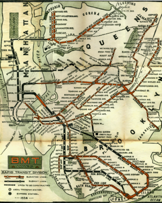
Starting in 1899, the Brooklyn Rapid Transit Company and Brooklyn–Manhattan Transit Corporation operated rapid transit lines in New York City — at first only elevated railways and later also subways.

South Street is a street in Lower Manhattan, New York City, located immediately adjacent to the East River. It runs from Whitehall Street near the southern tip of Manhattan to Jackson Street near the Williamsburg Bridge. An elevated portion of FDR Drive, known as the South Street Viaduct, runs along the entire length of the street.

Brooklyn Bridge Park is an 85-acre (34 ha) park on the Brooklyn side of the East River in New York City. Designed by landscape architecture firm Michael Van Valkenburgh Associates, the park is located on a 1.3-mile (2.1 km) plot of land from Atlantic Avenue in the south, under the Brooklyn Heights Promenade and past the Brooklyn Bridge, to Jay Street north of the Manhattan Bridge. From north to south, the park includes the preexisting Empire–Fulton Ferry and Main Street Parks; the historic Fulton Ferry Landing; and Piers 1–6, which contain various playgrounds and residential developments. The park also includes Empire Stores and the Tobacco Warehouse, two 19th-century structures, and is a part of the Brooklyn Waterfront Greenway, a series of parks and bike paths around Brooklyn.

The Atlantic Avenue Railroad was a company in the U.S. state of New York, with a main line connecting downtown Brooklyn with Jamaica along Atlantic Avenue. It was largely a streetcar company that operated its own trains, but the Long Island Rail Road operated both streetcars and steam trains over its main line. It later became part of the Nassau Electric Railroad, but is now divided between the active Atlantic Branch of the LIRR and the unused Cobble Hill Tunnel, which is preserved in its original state, albeit without service tracks.

The Nassau Electric Railroad was an electric street railway company in the U.S. state of New York. The company operated throughout the borough of Brooklyn, as well as over the Brooklyn Bridge and Williamsburg Bridge into Manhattan.

The Fifth Avenue Line, also called the Fifth Avenue Elevated or Fifth Avenue–Bay Ridge Line, was an elevated rail line in Brooklyn, New York City, United States. It ran above Hudson Avenue, Flatbush Avenue, Fifth Avenue, 38th Street, and Third Avenue from Downtown Brooklyn south to Bay Ridge. The portion on Third Avenue was called the Third Avenue Elevated to distinguish service from the elevated BMT West End Line; it was separate from the elevated IRT Third Avenue Line in Manhattan and the Bronx.
The Brooklyn and North River Line, operated by the Brooklyn and North River Railroad, was a trolley line in Manhattan and Brooklyn, New York City, United States. Its route ran from the Desbrosses Street Ferry across Lower Manhattan via the Canal Street Crosstown Line, over a pair of tracks on the east side of the Manhattan Bridge, and to the intersection of Flatbush Avenue and Fulton Street in Downtown Brooklyn. Operation in Manhattan and over the bridge was with conduit electrification, while in Brooklyn it used overhead trolley wire, switching at a plow pit.
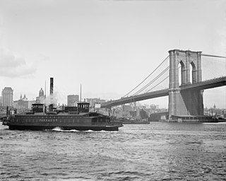
The Fulton Ferry was the first steam ferry route connecting Manhattan and Brooklyn, New York City, United States, joining Fulton Street, Manhattan, and Fulton Street, Brooklyn, across the East River. It revolutionized travel between the then City of New York on Manhattan Island and the Village of Brooklyn and the rest of Long Island. Robert Fulton's steam Fulton Ferry Company in 1814 established his name on the ferry service. After the Brooklyn Bridge was built, ridership declined, and the ferry ceased operation on January 19, 1924. NYC Ferry now serves a very similar route.

The Gouverneur Street Ferry was a ferry route connecting Manhattan, New York City, with the city of Brooklyn, by joining Manhattan's Gouverneur Street to Brooklyn's Bridge Street across the East River.

Transportation in New York City has ranged from strong Dutch authority in the 17th century, expansionism during the industrial era in the 19th century and half of the 20th century, to cronyism during the Robert Moses era. The shape of New York City's transportation system changed as the city did, and the result is an expansive modern-day system of industrial-era infrastructure. New York City, being the most populous city in the United States, has a transportation system which includes one of the largest subway systems in the world; the world's first mechanically ventilated vehicular tunnel; and an aerial tramway.

The East 34th Street Ferry Landing provides slips to ferries and excursion boats in the Port of New York and New Jersey. It is located on the East River in New York City east of the FDR Drive just north of East 34th Street in Midtown Manhattan. The facility, owned by the city, received Federal Highway Administration funding for improvements for docking facilities and upgrading the adjacent East River Greenway in 2008. A new terminal was built and completed in 2012.