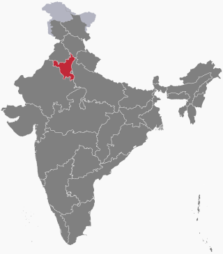
Haryana is a state located in the northern part of India. It was carved out after the linguistic reorganisation of Punjab on 1 November 1966. It is ranked 21st in terms of area, with less than 1.4% of India's land area. The state capital is Chandigarh, which it shares with the neighbouring state of Punjab; the most populous city is Faridabad, a part of the National Capital Region. The city of Gurgaon is among India's largest financial and technology hubs. Haryana has 6 administrative divisions, 22 districts, 72 sub-divisions, 93 revenue tehsils, 50 sub-tehsils, 140 community development blocks, 154 cities and towns, 7,356 villages, and 6,222 villages panchayats.

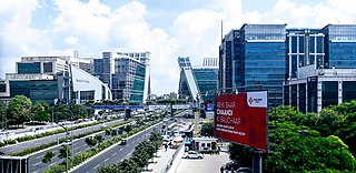
Gurgaon, officially named Gurugram, is a tier-2 satellite city of Delhi and administrative headquarters of Gurgaon district, located in the northern Indian state of Haryana. It is situated near the Delhi–Haryana border, about 30 kilometres (19 mi) southwest of the national capital New Delhi and 268 km (167 mi) south of Chandigarh, the state capital. It is one of the major satellite cities of Delhi and is part of the National Capital Region of India. As of 2011, Gurgaon had a population of 876,969.

Bhakra Nangal Dam is a concrete gravity dam on the Satluj River in Bhakra Village in Bilaspur district, Himachal Pradesh in northern India. The dam forms the Gobind Sagar reservoir. Nangal Dam is another dam at Nangal in Punjab downstream of Bhakra Dam. However, sometimes both the dams together are called Bhakra-Nangal Dam though they are two separate dams.
Pataudi is a town, a tehsil and one of the 4 sub-divisions of Gurugram district, in the Indian state of Haryana, within the boundaries of the National Capital Region of India. It is located 28 km (17.4 mi) southwest of Gurugram city.

Rewari district is one of the 22 districts in the state of Haryana, India. It was carved out of Gurgaon district by the Government of Haryana on 1 November 1989. It is also part of the National Capital Region. The administrative headquarter of the district is the city of Rewari, which is also the biggest city in the district. In medieval times, it was an important market town. It is located in southern Haryana. As of 2011, it is the second least populous district of Haryana after Panchkula.
Rewari is a city and a municipal council in Rewari district in the Indian state of Haryana. It is district headquarter of Rewari district. It is located in south-west Haryana around 82 km from Delhi and 51 km from Gurgaon. It lies in Ahirwal region.
Rohtak is a city and the administrative headquarters of the Rohtak district in the Indian state of Haryana. It lies 70 kilometres (43 mi) north-west of New Delhi and 250 kilometres (160 mi) south of the state capital Chandigarh on NH 9. Rohtak forms a part of the National Capital Region (NCR) which helps the city in obtaining cheap loans for infrastructure development from the NCR Planning Board.
Farrukhnagar is a small town and municipality in Farrukhnagar tehsil of Gurugram district in the Indian state of Haryana. It is situated 21 kilometres (13 mi) from Gurgaon and shares its border with Jhajjar district. It was established in 1732 by Faujdar Khan, the first Nawab of Farrukhnagar and a governor of the Mughal Emperor Farrukhsiyar. Farrukhnagar flourished due to its salt trade until the late 19th century, and was abandoned in the early 20th century, during the British Raj. Today monuments such as Sheesh Mahal, Baoli and Jama Masjid built by Faujdar Khan are popular visitor attractions. The town is connected to Garhi Harsaru, south of Gurugram, by the railway line. The Sultanpur National Park is situated in Farrukhnagar tehsil on the road to Gurgaon. Pataudi Palace, 12 kilometres (7.5 mi) from the town, is the nearest palace.
Rao Inderjit Singh is an Indian politician who is serving as the 17th minister of Planning, Statistics and Programme Implementation and minister of state in the ministry of Culture since 2024. He is also a member of the Lok Sabha. He represents the Gurgaon constituency in Haryana and is a member of Bharatiya Janata Party. He was elected to 18th Lok Sabha from Gurgaon with a majority of 75,079 votes.

Manesar is a town and municipal corporation, known as New gurgaon city in the Gurugram district of the state of Haryana, India and a part of the National Capital Region (NCR) of Delhi. It is an Industrial Model Township home to factories and industrial activity from multinational corporations.

Haryana is a state in India. The state houses several sites from the Indus Valley Civilization, which was a cradle of civilisation. In the Mahabharata, Haryana is mentioned as Bahudanayak Region.

Haryana, formed on 1 November 1966, is a state in North India. For the administrative purpose, Haryana is divided into 6 revenue divisions which are further divided into 22 districts. For Law and Order maintenance, it is divided into 5 Police Ranges and 4 Police Commissionerates.
GSDP of Haryana state is estimated to be US$140 billion in 2023-2024 which had grown at 12.96% CAGR between 2012–17, boosted by the fact that this state on DMIC in NCR contributes 7% of India's agricultural exports and 60% of India's Basmati rice export, with 7 operational SEZs and additional 23 formally approved SEZs. Haryana also produces India's 67% of passenger cars, 60% of motorcycles, 50% of tractors and 50% of the refrigerators, which places Haryana on 14th place on the list of Indian states and union territories by GDP behind only much bigger states that are significantly larger in both area and population.

Maharaja Rao Birender Singh was an Indian politician. He served first as a minister in the state government of Punjab and then as Chief Minister of Haryana, and also served as a minister in Punjab state, Haryana state and the Union cabinet. He also served as the second speaker of Haryana state assembly in 1967. He coined an Indian political vocabulary Aaya Ram, Gaya Ram to describe the practice of frequently floor-crossing by legislature.

Haryana Roadways State Transport (HR) is the public transport unit of the Government of Haryana in India. Haryana Roadways is a major part of Haryana Transport Department. It is the principal service provider for passenger transport in the state. The Consistent quality and punctuality of the service provider, apart from the polite behaviour of the staff have earned a name in all neighbouring state. They have become the first choice of the passengers.

Bawwa is a village in the Nahar Block of the Rewari District in Haryana, India. It is located 50 kilometres (31 mi) northwest of the district headquarters of Rewari, 10 kilometres (6.2 mi) west-southwest of Nahar, and 320 kilometres (200 mi) from the state capital Chandigarh. Karoli, Garhs, Sihor, Bahala, Naya-Gaon, and Gadhi are the neighboring villages. Bawwa is situated approximately 3 km from Karoli mod on Kanina-Bahu-Jholri road in the Rewari District.
The following outline is provided as an overview of and topical guide to Haryana.

Rail transport in the state of Haryana, India, is conducted by five rail divisions in three zones: the North Western Railway zone, Northern Railway zone, and North Central Railway zone. The Diamond Quadrilateral high-speed rail network, Eastern Dedicated Freight Corridor, and Western Dedicated Freight Corridor pass through Haryana.

Rajesh Khullar is a high-ranking Indian official and Chief Principal Secretary to Chief Minister, Haryana. Previously, he served on the board of the World Bank Group as India, Bangladesh, Bhutan, and Sri Lanka's representative. Khullar belongs to the IAS, India's elite civil service, tasked with commanding policy, governance, and administration nationwide.

