
Worcestershire is a ceremonial county in the West Midlands of England. It is bordered by Shropshire, Staffordshire, and the West Midlands county to the north, Warwickshire to the east, Gloucestershire to the south, and Herefordshire to the west. The city of Worcester is the largest settlement and the county town.

Offa's Dyke Path is a long-distance footpath loosely following the Wales–England border. Officially opened on 10 July 1971, by Lord Hunt, it is one of Britain's National Trails and draws walkers from throughout the world. About 60 miles (97 km) of the 177-mile (285 km) route either follows, or keeps close company with, the remnants of Offa's Dyke, an earthwork traditionally thought to have been constructed in the late 8th century on the orders of King Offa of Mercia.

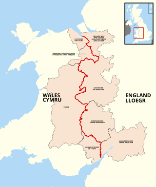
Powys is a county and preserved county in Wales. It borders Gwynedd, Denbighshire, and Wrexham to the north; the English ceremonial counties of Shropshire and Herefordshire to the east; Monmouthshire, Blaenau Gwent, Merthyr Tydfil, Caerphilly, Rhondda Cynon Taf, and Neath Port Talbot to the south; and Carmarthenshire and Ceredigion to the west. The largest settlement is Newtown, and the administrative centre is Llandrindod Wells.

The Forest of Dean is a geographical, historical and cultural region in the western part of the county of Gloucestershire, England. It forms a roughly triangular plateau bounded by the River Wye to the west and northwest, Herefordshire to the north, the River Severn to the south, and the City of Gloucester to the east.

The River Wye is the fourth-longest river in the UK, stretching some 250 kilometres from its source on Plynlimon in mid Wales to the Severn Estuary. For much of its length the river forms part of the border between England and Wales. The Wye Valley is designated an Area of Outstanding Natural Beauty. The Wye is important for nature conservation and recreation, but is affected by pollution.
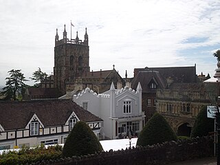
Malvern Hills is a local government district in Worcestershire, England. Its council is based in Malvern, the district's largest town. The district also includes the towns of Tenbury Wells and Upton-upon-Severn and a large rural area covering much of the western side of the county, including numerous villages. The district is named after the Malvern Hills, which are a designated Area of Outstanding Natural Beauty.

The A48 is a trunk road in Great Britain running from the A40 at Highnam, 3 miles (4.8 km) west of Gloucester, England, to the A40 at Carmarthen, Wales. Before the Severn Bridge opened on 8 September 1966, it was a major route between England and South Wales. For most of its route, it runs almost parallel to the M4 motorway. During times of high winds at the Severn Bridge, the A48 is used as part of the diversion route and is still marked as a Holiday Route.

Goodrich is a village and civil parish in south Herefordshire, England close to Gloucestershire and the Forest of Dean, situated near the River Wye at grid reference SO574193. It is known for its Norman and mediaeval castle built with Old Red Sandstone.

Ruardean Hill is a prominent hill and a village in the English county of Gloucestershire, 20 km (12 mi) west of Gloucester. It lies in the Forest of Dean, in the parish of Drybrook.

Archenfield is the historic English name for an area of southern and western Herefordshire in England. Since the Anglo-Saxons took over the region in the 8th century, it has stretched between the River Monnow and River Wye, but it derives from the once much larger Welsh kingdom of Ergyng.

The Shropshire Hills are a dissected upland area and one of the natural regions of England. They lie wholly within the county of Shropshire and encompass several distinctive and well-known landmarks, such as the Long Mynd, Wenlock Edge, The Wrekin and the Clees.

Beavan's Hill is a village in south east Herefordshire, England.

The Wye Valley National Landscape is an internationally important protected landscape straddling the border between England and Wales.

The Vale of Ewyas is the steep-sided and secluded valley of the River Honddu, in the Black Mountains of Wales and within the Brecon Beacons National Park. As well as its outstanding beauty, it is known for the ruins of Llanthony Priory, and for several noteworthy churches such as those at Capel-y-ffin and Cwmyoy. It is sometimes referred to as the "Llanthony Valley" as Llanthony is the village situated at the valley centre.
The England–Wales border, sometimes referred to as the Wales–England border or the Anglo-Welsh border, runs for 160 miles (260 km) from the Dee estuary, in the north, to the Severn estuary in the south, separating England and Wales.

The Doward, is an area in the parish of Whitchurch in south Herefordshire, England, consisting of the hills of Little Doward and Great Doward and extensive woodland. It is within the Wye Valley Area of Outstanding Natural Beauty, on the border with Monmouthshire, Wales. The area, about 3 miles (4.8 km) north-east of Monmouth, is shrouded in legend and King Arthur's Cave is in the vicinity.
The Natural Areas of England are regions, officially designated by Natural England, each with a characteristic association of wildlife and natural features. More formally, they are defined as "biogeographic zones which reflect the geological foundation, the natural systems and processes and the wildlife in different parts of England...".
A National Character Area (NCA) is a natural subdivision of England based on a combination of landscape, biodiversity, geodiversity and economic activity. There are 159 National Character Areas and they follow natural, rather than administrative, boundaries. They are defined by Natural England, the UK government's advisors on the natural environment.

The Mid Severn Sandstone Plateau is a rural landscape and one of the natural regions of central England, straddling the border between the counties of Shropshire and Staffordshire. It stretches from the western fringes of the Birmingham conurbation to Telford in the north and Kidderminster in the south. The major feature of the plateau is the valley of the River Severn, which cuts through it from north to south. It consists of Permian and Triassic-age New Red Sandstone getting older as one goes west until one reaches Silurian and Carboniferous-age siltstones and coals west of the river.
Cantref Coch was an area associated with the ancient kingdoms of Ergyng, Gwent and the later Kingdom of Glamorgan. Cantref Coch is linked with the modern Forest of Dean and is defined as the land between the River Severn and the River Wye, with the Severn Sea as its southern border although its northern border is less certain. It is one of the few medieval cantrefi named by Welsh writers that is not within the modern nation of Wales.
