
Postal codes used in the United Kingdom, British Overseas Territories and Crown dependencies are known as postcodes. They are alphanumeric and were adopted nationally between 11 October 1959 and 1974, having been devised by the General Post Office. A full postcode is known as a "postcode unit" and designates an area with several addresses or a single major delivery point.

The London postal district is the area in England of 241 square miles (620 km2) to which mail addressed to the London post town is delivered. The General Post Office under the control of the Postmaster General directed Sir Rowland Hill to devise the area in 1856 and throughout its history it has been subject to reorganisation and division into increasingly smaller postal units, with the early loss of two compass points and a minor retraction in 1866. It was integrated by the Post Office into the national postcode system of the United Kingdom during the early 1970s and corresponds to the E, EC, N, NW, SE, SW, W and WC postcode areas. The postal district has also been known as the London postal area. The County of London was much smaller, at 117 square miles (300 km2), but Greater London is much larger at 607 square miles (1,570 km2).

Avon was a non-metropolitan and ceremonial county in the west of England that existed between 1974 and 1996. The county was named after the River Avon, which flows through the area. It was formed from the county boroughs of Bristol and Bath, together with parts of the administrative counties of Gloucestershire and Somerset.

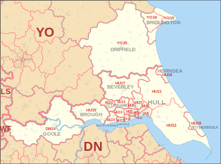
The East Riding of Yorkshire, or simply East Riding, is a ceremonial county and unitary authority area in the Yorkshire and the Humber region of England. It borders North Yorkshire to the north and west, South Yorkshire to the south-west, and Lincolnshire to the south.

North Lincolnshire is a unitary authority area in Lincolnshire, England, with a population of 167,446 in the 2011 census. The borough includes the towns of Scunthorpe, Brigg, Haxey, Crowle, Epworth, Bottesford, Kirton in Lindsey and Barton-upon-Humber. North Lincolnshire is part of the Yorkshire and Humber region.

The historic counties of England are areas that were established for administration by the Normans, in many cases based on earlier kingdoms and shires created by the Angles, Saxons, Jutes, Celts and others. They are alternatively known as ancient counties, traditional counties, former counties or simply as counties. In the centuries that followed their establishment, as well as their administrative function, the counties also helped define local culture and identity. This role continued even after the counties ceased to be used for administration after the creation of administrative counties in 1889, which were themselves amended by further local government reforms in the years following.
Humberside was a non-metropolitan and ceremonial county in Northern England from 1 April 1974 until 1 April 1996. It was composed of land from either side of the Humber Estuary, created from portions of the East Riding of Yorkshire, West Riding of Yorkshire, and the northern part of Lindsey, Lincolnshire. The county council's headquarters was County Hall at Beverley, inherited from East Riding County Council. Its largest settlement and only city was Kingston upon Hull. Other notable towns included Goole, Beverley, Scunthorpe, Grimsby, Cleethorpes and Bridlington. The county stretched from Wold Newton in its northern tip to a different Wold Newton at its most southern point.
The counties of England are areas used for different purposes, which include administrative, geographical, cultural and political demarcation. The term "county" is defined in several ways and can apply to similar or the same areas used by each of these demarcation structures. These different types of county each have a more formal name but are commonly referred to as just "counties". The current arrangement is the result of incremental reform.

The postal counties of the United Kingdom, now known as former postal counties, were postal subdivisions in routine use by the Royal Mail until 1996. The purpose of the postal county – as opposed to any other kind of county – was to aid the sorting of mail by differentiating between like-sounding post towns. Since 1996 this has been done by using the outward code of the postcode instead. For operational reasons the former postal counties, although broadly based on the counties of the United Kingdom, did not match up with their boundaries: in some cases there were significant differences. The boundaries changed over time as post towns were created or amended.
The Postcode Address File (PAF) is a database that contains all known "delivery points" and postcodes in the United Kingdom. The PAF is a collection of over 29 million Royal Mail postal addresses and 1.8 million postcodes. It is available in a variety of formats including FTP download and compact disc, and was previously available as digital audio tape. As owner of the PAF, Royal Mail is required by section 116 of the Postal Services Act 2000 to maintain the data and make it available on reasonable terms. A charge is made for lookup services or wholesale supply of PAF data. Charges are regulated by Ofcom. It includes small user residential, small user organisation and large user organisation details. There have been requests as part of the Open Data campaign for the PAF to be released by the government free of charge.

The Parts of Lindsey are a traditional division of Lincolnshire, England, covering the northern part of the county. The Isle of Axholme, which is on the west side of the River Trent, has normally formed part of it. The district's name originated from the Kingdom of Lindsey of Anglo-Saxon times, whose territories were merged with that of Stamford to form Lincolnshire.

Glanford was, from 1974 to 1996, a local government district with borough status in the non-metropolitan county of Humberside, England.
A post town is a required part of all postal addresses in the United Kingdom and Ireland, and a basic unit of the postal delivery system. Including the correct post town in the address increases the chance of a letter or parcel being delivered on time. Post towns in general originated as the location of delivery offices. As of 2004, their main function is to distinguish between localities or street names in addresses not including a postcode.

Metropolitan and non-metropolitan counties are one of the four levels of subdivisions of England used for the purposes of local government outside Greater London and the Isles of Scilly. As originally constituted, the metropolitan and non-metropolitan counties each consisted of multiple districts, had a county council and were also the counties for the purposes of Lieutenancies. Later changes in legislation during the 1980s and 1990s have resulted in counties with no county council and 'unitary authority' counties with no districts. Counties for the purposes of Lieutenancies are now defined separately, based on the metropolitan and non-metropolitan counties.
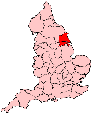
North Humberside is a former postal county of England. It was introduced by the Royal Mail on 1 July 1974, when some addresses were altered in response to the changes in administration brought about under the Local Government Act 1972.
The DN postcode area, also known as the Doncaster postcode area, is a group of 32 postcode districts in England, which are subdivisions of 13 post towns. These cover eastern South Yorkshire, north Lincolnshire, small parts of Nottinghamshire and the East Riding of Yorkshire, and a very small part of North Yorkshire.
The history of local government in Yorkshire is unique and complex. Yorkshire is the largest historic English county and consists of a diverse mix of urban and rural development with a heritage in agriculture, manufacturing, and mining. After a long period with little change, it has been subject to a number of reforms of local government structures in modern times, some of which were controversial. The most significant of these were the Local Government Act 1972, the 1990s UK local government reform, and the Localism Act 2011. The historic area currently corresponds to several counties and districts and is mostly contained within the Yorkshire and the Humber region.
The East Riding of Yorkshire is a local government district with unitary authority status, and is a ceremonial county of England. It is named after the historic East Riding of Yorkshire which was one of three ridings alongside the North Riding and West Riding, which were constituent parts a Yorkshire ceremonial and administrative county until 1974. From 1974 to 1996 the area of the modern East Riding of Yorkshire constituted the northern part of Humberside.
