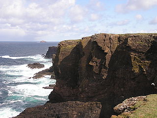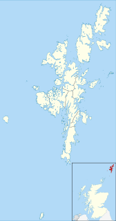
The South Isle of Gletness is an islet off Gletness, in Nesting in east central, Mainland, Shetland. It is 30m at its highest point.
Amongst its features are some caves.
The North Isle of Gletness is nearby.

The South Isle of Gletness is an islet off Gletness, in Nesting in east central, Mainland, Shetland. It is 30m at its highest point.
Amongst its features are some caves.
The North Isle of Gletness is nearby.

The Mainland is the main island of Shetland, Scotland. The island contains Shetland's only burgh, Lerwick, and is the center of Shetland's ferry and air connections.

Bressay is a populated island in the Shetland archipelago of Scotland.

Mousa is a small island in Shetland, Scotland, uninhabited since the nineteenth century. The island is known for the Broch of Mousa, an Iron Age round tower, and is designated as a Special Protection Area for storm-petrel breeding colonies.

The North Isles are the northern islands of the Shetland Islands, Scotland. The main islands in the group are Yell, Unst and Fetlar. Sometimes the islands in Yell Sound are included in this group.
The Garvellachs or Isles of the Sea form a small archipelago in the Inner Hebrides of Scotland. Part of the Argyll and Bute council area, they lie west of Lunga and northwest of Scarba and have been uninhabited since World War II.
Vaila is an island in Shetland, Scotland, lying south of the Westland peninsula of the Shetland Mainland. It has an area of 327 hectares, and is 95 metres (312 ft) at its highest point.

Out Stack or Ootsta is an island in Shetland, Scotland and the northernmost point of both Scotland and the British Isles.

Eilean Chathastail is one of the Small Isles in the Inner Hebrides of Scotland.

Isay is an uninhabited island in the Inner Hebrides of the west coast of Scotland. It lies in Loch Dunvegan, 1 kilometre (1,100 yd) off the northwest coast of the Isle of Skye. Two smaller isles of Mingay and Clett lie nearby. The name originated from the Old Norse ise-øy meaning porpoise island. The island of Lampay is due south. The area of Isay is 60 hectares.

Samphrey is an uninhabited island in the Shetland Islands, Scotland. One of Fair Isle's old names is "Friðarey" which is of similar origin.

The North Mainland of the Shetland Islands, Scotland is the part of the Mainland lying north of Voe.
Pabay is a Scottish island just off the coast of Skye. The name Pabay is derived from an old Norse word meaning "priest's isle" and there are the remains of a 13th-century chapel.
Pabay Mòr or Pabaigh Mòr is an uninhabited island in the Outer Hebrides of Scotland.

Little Roe is an island in Yell Sound in the Shetland Islands

Nesting is a parish in the Shetland Islands, Scotland. It includes a part of the east Shetland Mainland, measuring about twelve by four miles, along the seaboard from Gletness to Lunna Ness, and also the island of Whalsay and the Out Skerries. The coast is deeply indented by voes and headlands. The arable land comprises only about 1,000 acres, the remainder being mostly open moorland. The total area is given as 105.6 km2. This includes the ancient parish of Lunnasting in the North and the island parish of Whalsay to the east, which were added to Nesting in 1891. Before that, the ancient parishes of North Nesting and South Nesting were merged.

Hoo Stack is a small island off Nesting in Shetland. It is one and a half miles from the North Isle of Gletness. It is 34 metres (112 ft) at its highest point, and is home to a lighthouse, which was built in 1986.

The North Isle of Gletness is one of the Shetland Islands. It is east of the Shetland Mainland, near Gletness in Nesting parish, and is so called in contradistinction to the South Isle of Gletness. It is 33m at its highest point.
Geopark Shetland is the name used by the Geopark formally established in September 2009 on its entry into the European Geoparks Network. The Geopark extends across the entire Shetland archipelago off the north coast of mainland Scotland. It is administered by the Shetland Amenity Trust in partnership with organisations such as Scottish Natural Heritage, the Shetland Islands Council, Highlands and Islands Enterprise and various community and tourism associations.

Delting is a civil parish and community council area on Mainland, Shetland, Scotland. It includes the Sullom Voe oil terminal and its main settlements are Brae, Mossbank and Voe.
| Wikimedia Commons has media related to South Isle of Gletness . |
Coordinates: 60°14′N1°09′W / 60.233°N 1.150°W