Related Research Articles

The island of Maui is the second-largest island of the state of Hawaii at 727.2 square miles (1,883 km2), and the 17th-largest island in the United States. Maui is the largest of Maui County's four islands, which also include Molokaʻi, Lānaʻi, and unpopulated Kahoʻolawe. In 2020, Maui had a population of 168,307, the third-highest of the Hawaiian Islands, behind Oʻahu and Hawaiʻi Island. Kahului is the largest census-designated place (CDP) on the island, with a population of 28,219 as of 2020, and the island's commercial and financial hub. Wailuku is the seat of Maui County and is the third-largest CDP as of 2010. Other significant populated areas include Kīhei, Lāhainā, and Upcountry Maui.
Maui County, officially the County of Maui, is a county in the U.S. state of Hawaii. It consists of the islands of Maui, Lānaʻi, Molokaʻi, Kahoʻolawe, and Molokini. The latter two are uninhabited. As of the 2020 census, the population was 164,754. The county seat is Wailuku.

Kihei is a census-designated place (CDP) in Maui County, Hawaii, United States. The population was 21,423 at the 2020 census.

Mā'alaea is a census-designated place (CDP) in Maui County, Hawaii, United States. The population was 310 at the 2020 census. Mā‘alaea sits on the southern coast of the isthmus separating West Maui from the island’s Central Valley. Like other ahupua‘a, it widens as it descends from mountain slopes into the sea, occupying 5.4 square miles of land and 2.3 miles of ocean. For more than a millennium, Mā‘alaea has been a crossroads, a landing place for Hawaiian kings and armies, and in time, whalers and sailing ships. Highways follow the ancient trails that once branched north to Wailuku, west to Lahaina, and south to what are now the towns of Kīhei and Wailea. The name Mā‘alaea comes from the Hawaiian word ‘alae, the iron oxide from volcanic eruptions that gives the region its iron-rich red earth.

Haleakalā, or the East Maui Volcano, is a massive, active shield volcano that forms more than 75% of the Hawaiian Island of Maui. The western 25% of the island is formed by another volcano, Mauna Kahalawai, also referred to as the West Maui Mountains.
Kula is a district and census-designated place (CDP) of Maui, Hawaii. It stretches across Upcountry Maui, the western-facing slopes of Haleakalā. Most residential areas lie between about 500 to 1,100 m in elevation. The district is distinct from the generally hotter and busier coastal areas. The population of the Kula CDP at the 2020 Census was 6,942, while the larger Kula Census County Division, which includes the communities of upland Keokea and coastal Wailea and Makena, had a population of 12,864.
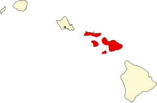
The following is an alphabetical list of articles related to the U.S. state of Hawaii:

Mākena State Park is a 165-acre (0.7 km2) beachside park in Makena on the island of Maui, Hawaii. Located just south of Wailea, it contains three separate beaches and a dormant volcanic cinder cone.

Keoneʻōʻio Bay is located south of the town of Wailea, Hawaii at the end of Mākena Alanui Road at 20°35′54″N156°25′12″W. The bay's Hawaiian name is Keoneʻōʻio.

Kealia Pond National Wildlife Refuge is a coastal salt marsh along the south-central coast of Maui, Hawaiʻi. The refuge is located between the towns of Kihei and Maalaea, on both sides of North Kihei Road, Route 31. The wetland is also a 691-acre (2.80 km2) bird sanctuary, home to 30 species of waterfowl, shorebirds, and migratory ducks, including the ʻaukuʻu and the endangered āeʻo and ʻalae keʻokeʻo. Kealia Pond was selected as a wildlife refuge in 1953, protecting an initial 300 acres (1.2 km2) of land. The refuge joined the National Wildlife Refuge System in 1992.
The Natural Area Reserves System (NARS) of Hawaii is a statewide attempt to preserve in perpetuity specific land and water areas which support communities, as relatively unmodified as possible, of the natural flora and fauna, as well as geological sites, of Hawaii.

Kekaha Kai State Park, formerly known as Kona Coast State Park, is a beach park located along the north Kona coast on the island of Hawaiʻi. The main beach areas are Maniniʻowali Bay, Makalawena beach at Puʻu Aliʻi Bay, and Mahaiʻula Bay. The park's name originates from the Hawaiian language words ke kaha kai which translate to "the shore line" in English.
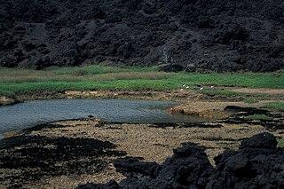
Established in 1973, ʻĀhihi-Kīnaʻu Natural Area Reserve includes a coastal lava field and surrounding waters on the southwest coast of the island of Maui, Hawaii. It consists of 1,238 acres (501 ha) on land and 807 acres (327 ha) of ocean along 3 miles (4.8 km) of Maui's southwestern coastline. The reserve includes several popular snorkeling/diving sites and many cultural and geologic sites as well as habitat for numerous rare and endangered species. The purpose and intent of the Reserve is to preserve and protect three unique components: the geologic setting of the most recent lava flow on Maui; unique assemblages of nearshore coral reef ecosystems; and the anchialine ponds found there.

Molokini is a crescent-shaped, partially submerged volcanic crater which forms a small, uninhabited islet located in ʻAlalākeiki Channel between the islands of Maui and Kahoʻolawe, within Maui County in Hawaiʻi. It is the remains of one of the seven Pleistocene epoch volcanoes that formed the prehistoric Maui Nui island, during the Quaternary Period of the Cenozoic Era.
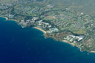
Wailea is a census-designated place (CDP) in Maui County, Hawaii, United States. As of the 2020 census, it had a population of 6,027. Prior to 2010, the area was part of the Wailea-Makena census-designated place. The community was developed in 1971 by a partnership of Alexander & Baldwin and Northwestern Mutual.

There are 75 golf courses in Hawaii.

Kīholo Bay is located in the ahupua`a of Pu`u Wa`awa`a in the North Kona District on the Big Island of Hawaii. the land surrounding the bay is flanked to the South by a lava flow from Mount Hualalai ca. 1801 and another flow from Mauna Loa in 1859. The land surrounding Kīholo Bay is under the authority of Hawai‘i State Parks. Approximately 2 miles long (3.2 km), it is one of the island's largest bays. Kīholo Bay is now a popular site for tourists and nature enthusiasts.

Mary McEldowney-Evanson co-founded the organization Friends of Haleakalā National Park in partnership with the National Park Service, and her name became synonymous with environmental activism on Maui. December 20 was proclaimed as "Mary Evanson Day" by Maui Mayor Alan Arakawa to honor her 95th birthday in 2016. Evanson's conservation work is well recognized by the conservation community because there is scarcely an environmental health group in Maui where Evanson was not involved with their founding. Evanson died in May 2019 at the age of 97.
References
- ↑ "One'uli Black Sand Beach". 16 November 2012.