It has been in the past susceptible to tidal and flooding inundations.[1][2]
It has been a desirable location for real estate looking across the Swan River to the city of Perth, as well as watching the City of Perth Skyworks. The South Perth City council lists it as a park/reserve that can be hired.[3]
The Swan River is a major river in the south west of Western Australia. The river runs through the metropolitan area of Perth, Western Australia's capital and largest city.
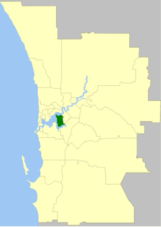
The City of South Perth is a local government area in the inner southern suburbs of the Western Australian capital city of Perth about 4 kilometres (2.5 mi) south of Perth's central business district. The City covers an area of 19.9 square kilometres (7.7 sq mi), maintains 203 kilometres (126 mi) of roads and a little over 4.3 km2 of parks and gardens, and had a population of about 42,000 at the 2016 Census. The City is the entirety of the state electoral district of South Perth. An area of Kensington joined into South Perth after the 2013 redistribution, although dwindling population growth in Victoria Park may mean that part of the City will move back.
Salter Point is a suburb of Perth, Western Australia, located in the City of South Perth local government area.
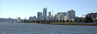
Perth Water is a section of the Swan River on the southern edge of the central business district of Perth, Western Australia. It is between the Causeway to the east, and Narrows Bridge to the west – a large wide but shallow section of river, and the northern edge of the suburb South Perth. It is considered a landmark of the City of Perth.
Matilda Bay or Crawley Bay is a natural bay in the Swan River in Western Australia, adjacent to the Perth suburb of Crawley. It extends from Pelican Point to Mounts Bay Road below Kings Park.
Point Belches is a small point on the south side of Swan River, Western Australia, about 250 metres (820 ft) east of The Narrows within the area known as Perth Water. The land is part of the South Perth Esplanade, and the water off the point is used as a commercial water skiing area.
Christies Beach is a seaside suburb in the southern Adelaide metropolitan area, within the City of Onkaparinga. The area is scenic and hence popular with photographers as Witton Bluff provides a natural vantage point over the entire suburb and beyond.
The Esplanade Reserve in Perth, Western Australia was a heritage listed public space between Perth Water and the Perth central business district. It formed part of, and was occasionally referred to incorrectly as, the Perth foreshore and the Perth waterfront. The public space was resumed by the Western Australian state government in April 2012 as part of the Elizabeth Quay redevelopment of the Perth waterfront area.
The north shore of Perth Water on the Swan River frontage to the city of Perth in Western Australia has been frequently changed since the arrival of Europeans in 1829. Various forms and structures have appeared and been removed over the last 190 years. Jetties, ports and various forms of reclamation have moved the shore considerably into Perth Water. The main eras of reclamation were in the 1870s, 1900s, 1920s-1937, 1955–1959, and 1967.
Riverside Drive in Perth, Western Australia, is a road on the northern side of Perth Water. It was built on reclaimed land in the 1930s, and links The Causeway to the Narrows Bridge.
Lawson Apartments are located at 2–4 Sherwood Court near the corner with The Esplanade, in Perth, Western Australia. They are situated across the road from the Esplanade Reserve and adjacent to the Weld Club.
Queens Gardens, Perth, is a 3.3-hectare (8.2-acre) park on a former brickworks and clay pit site in the eastern end of the Perth central business district. The park is bounded by Hay Street to the south, Plain Street to the west, Nelson Crescent to the north, and Hale Street to the east, which separates it from the WACA Ground.
Elizabeth Quay is a mixed-use development project in the Perth central business district. Encompassing an area located on the north shore of Perth Water near the landmark Swan Bells, the precinct was named in honour of Queen Elizabeth II during her Diamond Jubilee.
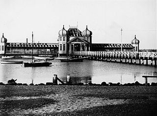
Perth City Baths was a public swimming facility, located on the north shore of Perth Water on the Swan River, in Perth, Western Australia. During his 1881 sojourn in Perth, exhibition impresario, Jules Joubert, had recommended that the City consider a public bath. The baths were opened in 1885, with segregated bathing. The ornate Moorish style building was opened on 5 March 1898 by the Mayor of Perth, Alexander Forrest and was leased to the Perth City Council. Costing £2600 with government support, the mostly jarrah building had four towers capped by cupolas and was designed by G.R. Johnson and built by C. Nelson.
Capitol Theatre was a George Temple-Poole designed theatre and cinema located at 10 William Street Perth.
The Esplanade Hotel was a hotel on The Esplanade across from Esplanade Reserve in Perth, Western Australia. Its demolition in 1972 was controversial because of the building's beauty and popularity.
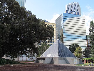
The Allan Green Conservatory was a pyramid shaped botanical display facility on the Esplanade Reserve in Perth, Western Australia.
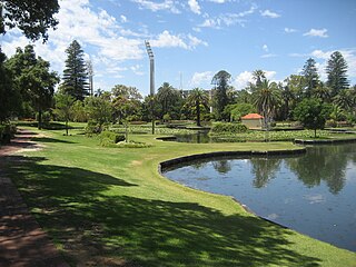
Sir James Mitchell Park is a park along the southern foreshore of Perth Water in Perth, Western Australia. It lies within the suburb of South Perth from Mends Street Jetty, to just south of Heirisson Island.
Esplanade Park is a public reserve in Fremantle, Western Australia. Situated on Marine Terrace and opposite the Esplanade Hotel, the reserve features about 100 mature Norfolk Island pines and the Explorers' Monument.
This page is based on this Wikipedia article Text is available under the CC BY-SA 4.0 license; additional terms may apply. Images, videos and audio are available under their respective licenses.