It was formerly a riverside area with a number of issues regarding management. In the 1950s market gardens were closed in the area.[1]
Since the 1970s considerable effort has been made to improve amenity, access and environmental issues.[2][3]
The South Perth City Council considers the park, or parts of it to be suitable for hire, and it has hosted numerous events since its improvements and landscaping.[4]
As of December 2015[update] it is a very regularly used location for cyclists, runners and dog walkers around the river, with links to a circuit that continues around the whole of Perth Water, utilising pedestrian facilities on the Narrows Bridge and The Causeway.
↑ Swan River Trust (W.A.); South Perth (W.A.: Municipality). Council (2001), Sir James Mitchell Park foreshore management plan, Swan River Trust, ISBN978-0-7309-7525-0
The Swan River is a river in the south west of Western Australia. The river runs through the metropolitan area of Perth, Western Australia's capital and largest city.
The Town of Victoria Park is a local government area of Western Australia. It covers an area of 17.62 km² in metropolitan Perth, the capital of Western Australia. It had a population of approximately 35,000 as at the 2016 Census.
Salter Point is a suburb of Perth, Western Australia, located in the City of South Perth local government area.
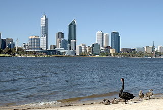
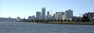
Perth Water is a section of the Swan River on the southern edge of the central business district of Perth, Western Australia. It is between the Causeway to the east, and Narrows Bridge to the west – a large wide but shallow section of river, and the northern edge of the suburb South Perth. It is considered a landmark of the City of Perth.
The Causeway is an arterial traffic crossing in Perth, Western Australia, linking the inner-city suburbs of East Perth and Victoria Park. It is carried over the Swan River at the eastern end of Perth Water by two bridges on either side of Heirisson Island. The current Causeway is the third structure to have been built across the river at this point.
The Canning River is a major tributary of the Swan River in the South West Land Division of Western Australia. It is home to much wildlife including dolphins, pelicans, swans and many other bird species.
The Blackwood River is a major river and catchment in the South West of Western Australia.
Matilda Bay or Crawley Bay, then Sutherland's Bay) is a natural bay in the Swan River in Western Australia, adjacent to the Perth suburb of Crawley. It extends from Pelican Point to Mounts Bay Road below Kings Park.
Point Belches is a small point on the south side of Swan River, Western Australia, about 250 metres (820 ft) east of The Narrows within the area known as Perth Water. The land is part of the South Perth Esplanade, and the water off the point is used as a commercial water skiing area.
South Perth is a residential suburb of Perth, Western Australia that adjoins the southern shore of Perth Water on the Swan River; it is 3 kilometres (2 mi) south of the central business district. The suburb adjoins two major arterial roads—Canning Highway and the Kwinana Freeway, and is within the City of South Perth local government area.
Freshwater Bay is a bay of the Swan River, in metropolitan Perth, Western Australia. It is about 5 km upstream from the mouth of the river at Fremantle and is overlooked by the suburbs of Dalkeith, Claremont, Mosman Park and Peppermint Grove. Freshwater Bay was named after Freshwater Bay and Freshwater, Isle of Wight by Henry Charles Prinsep (1844-1922), who had a riverside family holiday cottage there, The Chine.
Blackwall Reach is a section of the Swan River in Western Australia.
The Murray River is a river in the southwest of Western Australia. It played a significant part in the expansion of settlement in the area south of Perth after the arrival of British settlers at the Swan River Colony in 1829.
The W.A. Heritage Trails Network is a network of heritage trails and places in Western Australia that was initially funded by the Australian Commonwealth/State Bicentennial Commemorative Program for the 1988 Australian Bicentenary. In many cases local communities and councils collaborated with the National Trust of Australia (WA) to research and develop local trails.
Claise Brook is a stream which empties into Claisebrook Cove before running into the Swan River in Perth, Western Australia. The area surrounding the stream is on the outskirts of the Perth CBD and is part of the suburb of East Perth. Claise Brook was once an important water course from which the numerous interconnected fresh water lakes north of Perth emptied into during the wet season before entering the Swan River.
The north shore of Perth Water on the Swan River frontage to the city of Perth in Western Australia has been frequently changed since the arrival of Europeans in 1829. Various forms and structures have appeared and been removed over the last 190 years. Jetties, ports and various forms of reclamation have moved the shore considerably into Perth Water. The main eras of reclamation were in the 1870s, 1900s, 1920s-1937, 1955–1959, and 1967.
Riverside Drive in Perth, Western Australia, is a road on the northern side of Perth Water. It was built on reclaimed land in the 1930s, and links The Causeway to the Narrows Bridge.
South Perth Esplanade is the name of the foreshore area of Perth Water from Point Belches to Mends Street Jetty in South Perth, Western Australia.
Dalkeith Hot Pool was an open air hot spring in Dalkeith, Western Australia. It was situated on the foreshore of the Swan River near Sunset Heritage Precinct at the foot of the escarpment.
Swan Canning Riverpark consists of the waterways and public foreshore reserves in the Swan and Canning Rivers in Perth, Western Australia. Established under the Swan and Canning Rivers Management Act 2006, it has an area of 72.1 square kilometres (27.8 sq mi).
This page is based on this Wikipedia article Text is available under the CC BY-SA 4.0 license; additional terms may apply. Images, videos and audio are available under their respective licenses.