Lamorna is a village, valley and cove in west Cornwall, England, UK. It is on the Penwith peninsula approximately 4 miles (6 km) south of Penzance. Lamorna became popular with the artists of the Newlyn School, including Alfred Munnings, Laura Knight and Harold Knight, and is also known for former residents Derek and Jean Tangye who farmed land and wrote "The Minack Chronicles".

Newquay is a town on the north coast in Cornwall, England, United Kingdom. It is a civil parish, seaside resort, regional centre for aerospace industries with an airport and a spaceport, and a fishing port on the North Atlantic coast of Cornwall, approximately 12 miles (19 km) north of Truro and 20 miles (32 km) west of Bodmin.

Penzance is a town, civil parish and port in the Penwith district of Cornwall, England, United Kingdom. It is the westernmost major town in Cornwall and is about 64 miles (103 km) west-southwest of Plymouth and 255 miles (410 km) west-southwest of London. Situated in the shelter of Mount's Bay, the town faces south-east onto the English Channel, is bordered to the west by the fishing port of Newlyn, to the north by the civil parish of Madron and to the east by the civil parish of Ludgvan. The civil parish includes the town of Newlyn and the villages of Mousehole, Paul, Gulval, and Heamoor. Granted various royal charters from 1512 onwards and incorporated on 9 May 1614, it has a population of 21,200.
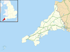
Hugh Town is the largest settlement on the Isles of Scilly and its administrative centre. The town is situated on the island of St Mary's, the largest and most populous island in the archipelago, and is located on a narrow isthmus which joins the peninsula known as the Garrison with the rest of the island.

Portland Harbour is located beside the Isle of Portland, Dorset, on the south coast of England. Construction of the harbour began in 1849; when completed in 1872, its 520-hectare (1,300-acre) surface area made it the largest human-made harbour in the world, and it remains one of the largest in the world today. It is naturally sheltered by Portland to the south, Chesil Beach to the west and mainland Dorset to the north. It consists of four breakwaters: two southern and two northern. These have a total length of 4.57 km (2.84 mi) and enclose approximately 1,000 ha of water.

Porthleven is a town, civil parish and fishing port near Helston, Cornwall, England, United Kingdom. The most southerly port in Great Britain, it was a harbour of refuge when this part of the Cornish coastline was infamous for wrecks in the days of sail. The South West Coast Path from Somerset to Dorset passes through the town. The population at the 2011 census was 3,059.

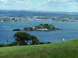
Mount's Bay is a bay on the English Channel coast of Cornwall, England, stretching from the Lizard Point to Gwennap Head. In the north of the bay, near Marazion, is St Michael's Mount; the origin of name of the bay. In summer, it is a generally benign natural harbour. However, in winter, onshore gales present maritime risks, particularly for sailing ships. There are more than 150 known wrecks from the nineteenth century in the area. The eastern side of the bay centred around Marazion and St Michael's Mount was designated as a Marine Conservation Zone in January 2016.

Par is a village and fishing port with a harbour on the south coast of Cornwall, England, United Kingdom. The village is situated in the civil parish of Tywardreath and Par, although West Par and the docks lie in the parish of St Blaise.

St Austell station is a Grade II listed station which serves the town of St Austell, Cornwall, England. It is 286 miles 26 chains from the zero point at London Paddington measured via Box and Plymouth Millbay. The station is operated by Great Western Railway.

Truro railway station serves the city of Truro, Cornwall, England. The station is on the Cornish Main Line and is the junction for the Maritime Line to Falmouth Docks. It is situated at milepost 300.75 miles (484.01 km) from London Paddington, which is measured via Bristol Temple Meads, although most trains use the shorter route via Newbury.

Penzance railway station serves the town of Penzance in west Cornwall, England. It is the terminus of the Cornish Main Line and the southernmost railway station in Great Britain, situated at milepost 326.5 miles (525.5 km) from London Paddington. The station is owned by Network Rail and managed by Great Western Railway who also operate train services there, together with CrossCountry.
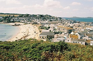
Gulval is a village in the civil parish of Penzance, in Cornwall, England. Although historically a parish in its own right, Gulval was incorporated into the parishes of Ludgvan, Madron and Penzance in 1934, and is now considered to be a suburb of Penzance. Gulval still maintains its status as an ecclesiastical parish and parts of the village church date back to the 12th-century. Together with Heamoor, Gulval still retains its status as an electoral ward. The ward population at the 2011 census was 4,185.
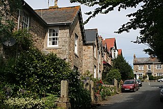
Mullion Cove, or Porth Mellin, is a small community on the West Coast of the Lizard Peninsula in Cornwall, England, and on the eastern side of Mount's Bay. The Cove forms part of the parish of Mullion, and is accessible by road from Mullion village, 1 mile (1.6 km) to the northeast, and also via the South West coast path. It lies within an Area of Outstanding Natural Beauty.
Mount Edgcumbe Country Park is listed as Grade I on the National Register of Historic Parks and Gardens and is one of four designated country parks in Cornwall, England, United Kingdom. The 885 acres (3.58 km2) country park is on the Rame Peninsula, overlooking Plymouth Sound and the River Tamar. The park has been famous since the 18th century, when the Edgcumbe family created formal gardens, temples, follies and woodlands around the Tudor house. Specimen trees, such as Sequoiadendron giganteum, stand against copses which shelter a herd of wild fallow deer. The South West Coast Path runs through the park for nine miles (14 km) along the coastline.

Donaghadee Lighthouse is a lighthouse in Donaghadee County Down, Northern Ireland. Donaghadee is probably best known for its lighthouse and harbour. There has been a haven for ships at Donaghadee for centuries, and there has also existed a harbour since at least the 17th century.

Angarrack railway viaduct crosses the valley of the Angarrack River at Angarrack in west Cornwall, England, United Kingdom.

Penlee Lifeboat Station is the base for Royal National Lifeboat Institution (RNLI) search and rescue operations for Mount's Bay in Cornwall, United Kingdom. The lifeboat station operated at various locations in Penzance from the early 19th century. It moved to Penlee Point near Mousehole in 1913, thus gaining its current name, but was moved to Newlyn in 1983 without any change of name. The station is remembered for the loss of the entire lifeboat crew on 19 December 1981.
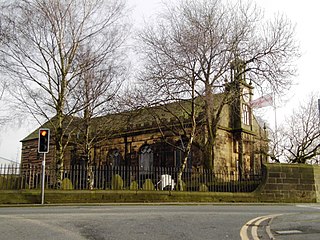
St Aidan's Church is in Main Street, Billinge, St Helens, Merseyside, England. It is an active Anglican parish church in the diocese of Liverpool. It was built in 1716–18 to replace a chapel of ease on the site, and was remodelled and extended in 1907–08. The church is recorded in the National Heritage List for England as a designated Grade II* listed building.

Scarborough Pier Lighthouse is an active aid to navigation on Vincent Pier in Scarborough, North Yorkshire, owned and operated by Scarborough Borough Council. The lighthouse dates from 1806, but it had to be rebuilt following damage sustained in the German bombardment of 1914.
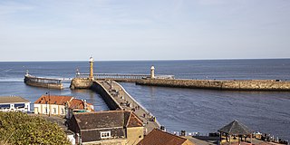
The piers of Whitby are four structures along the River Esk estuary in Whitby, North Yorkshire, England. Whilst all the piers can be accessed by the general public, the piers were not built as seaside attractions – so-called pleasure piers like Redcar, Saltburn or Withernsea – but rather serving a civil purpose, such as ship loading and protecting the harbour. The main West and East piers in the town were built to provide shelter from the currents and storms of the North Sea, and in the 18th and 19th centuries, any ships seeking refuge in the harbour were charged a levy for use of Whitby's safe haven. These levies were used to pay for the maintenance and improvement of the piers.