The Oyster Rocks are a close pair of small granite islands, with a combined area of about 6 ha, in south-eastern Australia. They are part of Tasmania’s Tin Kettle Island Group, lying in eastern Bass Strait between Flinders and Cape Barren Islands in the Furneaux Group. They are a conservation area. The islands are part of the Franklin Sound Islands Important Bird Area, identified as such by BirdLife International because it holds over 1% of the world populations of six bird species.

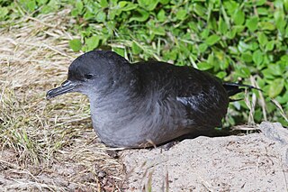
Steep Island, also known as Steep Head, is a 21.6 ha island in Bass Strait in south-eastern Australia. It is part of Tasmania’s Hunter Island Group and lies between north-west Tasmania and King Island. It was once used for grazing sheep but title has been transferred to the Tasmanian Aboriginal community; with an estimated 250,000 shearwater burrows present, it is principally used for muttonbirding.
Nares Rocks are a group of three rocks with a total area of 0.76 ha in Bass Strait, part of Tasmania’s Hunter Island Group and lie between north-west Tasmania and King Island. They are steep and largely bare of vegetation.
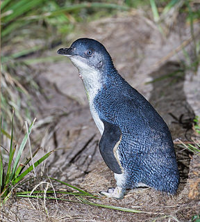
Bird Island is an island game reserve, with an area of 43.92 ha, in Bass Strait, south-eastern Australia. It is part of Tasmania’s Hunter Island Group which lies between north-west Tasmania and King Island. It is home to about 5,000 pairs of short-tailed shearwaters, the young of which are harvested annually, and about 3,000 pairs of little penguins.
Dugay Islet is a small island with an area of 0.44 ha in Bass Strait, north-western Tasmania.
Edwards Islet is a small island with an area of 0.58 ha in Bass Strait, south-eastern Australia. It is part of Tasmania’s Hunter Island Group which lies between north-west Tasmania and King Island.
Penguin Islet is a small island nature reserve with an area of 3.46 ha in Bass Strait, south-eastern Australia. It is part of Tasmania’s Hunter Island Group which lies between north-west Tasmania and King Island. It is notable as the only pelican colony in western Bass Strait.
Bears Island is a small island with an area of 0.34 ha, lying off the north-west tip of Three Hummock Island in Bass Strait, south-eastern Australia. It is part of Tasmania’s Hunter Island Group which lies between north-west Tasmania and King Island.
Black Pyramid Rock is an island nature reserve, with an area of 40 ha, in Bass Strait, south-eastern Australia. It is part of Tasmania’s Hunter Island Group which lies between north-west Tasmania and King Island. It is part of the Albatross Island and Black Pyramid Rock Important Bird Area. It is notable for its Australasian gannet colony which, at over 12,000 pairs, is the largest in Tasmania and supports about 20% of the world population of the species.
South Black Rock is a small island with an area of <1 ha, in Bass Strait, south-eastern Australia. It is part of Tasmania’s Hunter Island Group which lies between north-west Tasmania and King Island.

Little Trefoil Island is a small island with an area of 0.64 ha, in south-eastern Australia. It is part of Tasmania’s Trefoil Island Group, lying close to Cape Grim, Tasmania’s most north-westerly point, in Bass Strait.

The Harbour Islets are a group of two adjacent small rocky islands, joined at low tide, part of Tasmania’s Trefoil Island Group, lying close to Cape Grim, Tasmania’s most north-westerly point, in Bass Strait, with a combined area of 3.13 ha, in south-eastern Australia.
Little Stony Petrel Island is an island game reserve with an area of 4 ha, in south-eastern Australia. It is part of the Petrel Island Group, lying in Bass Strait close to Walker and Robbins Islands in north-west Tasmania.
Big Stony Petrel Island is an island game reserve with an area of 7.2 ha, in south-eastern Australia. It is part of the Petrel Island Group, lying in Bass Strait close to Walker and Robbins Islands in north-west Tasmania.
Big Sandy Petrel Island is an island game reserve with an area of 15.2 ha, in south-eastern Australia. It is part of the Petrel Island Group, lying in Bass Strait close to Walker and Robbins Islands in north-west Tasmania.
Howie Island is an island, with an area of 4.1 ha, in south-eastern Australia. It is part of the Petrel Island Group, lying in Bass Strait close to Walker and Robbins Islands in north-west Tasmania. It is surrounded by extensive mudflats.

Sentinel Island is a granite island, with an area of 10 ha, in south-eastern Australia. It is part of Tasmania’s Sentinel Island Group, lying in eastern Bass Strait off the north-west coast of Flinders Island in the Furneaux Group. Until 1985 it was used for grazing sheep.
South Pasco Island is an island, with an area of 21 ha, in south-eastern Australia. It is part of Tasmania’s Pasco Island Group, lying in eastern Bass Strait off the north-west coast of Flinders Island in the Furneaux Group. It is used for grazing sheep.
The Low Islets are two small, flat, adjacent, granite islands, with a combined area of about 2 ha, in south-eastern Australia. They are part of Tasmania’s Prime Seal Island Group, lying in eastern Bass Strait west of Flinders in the Furneaux Group. The larger of the two islets has been used for grazing sheep, cattle and horses.
Wybalenna Island comprises four round granite islands with a combined area of about 16 ha, in south-eastern Australia. It is part of Tasmania’s Prime Seal Island Group, lying in eastern Bass Strait west of Flinders in the Furneaux Group. The island is a conservation area