
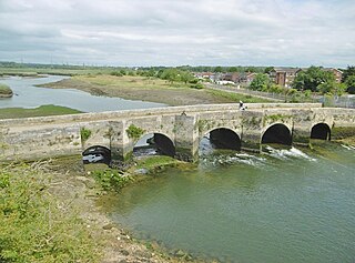
Newport is the county town of the Isle of Wight, an island county off the south coast of England. The town is slightly north of the centre of the island, located in the civil parish of Newport and Carisbrooke. It has a quay at the head of the navigable section of the River Medina, which flows northwards to Cowes and the Solent. The 2021 census recorded a population of 25,407.

The counties of England are a type of subdivision of England. Counties have been used as administrative areas in England since Anglo-Saxon times. There are three definitions of county in England: the 48 ceremonial counties used for the purposes of lieutenancy; the 84 metropolitan and non-metropolitan counties for local government; and the 39 historic counties which were used for administration until 1974.

South Glamorgan is a preserved county of Wales.
Kerrier was a local government district in Cornwall, England, United Kingdom. It was the most southerly district in the United Kingdom, other than the Isles of Scilly. Its council was based in Camborne. Other towns in the district included Redruth and Helston. The district also contained the Lizard Peninsula.

Weymouth and Portland was a local government district with borough status in Dorset, England from 1974 to 2019. It consisted of the resort of Weymouth and the Isle of Portland, and includes the areas of Wyke Regis, Preston, Melcombe Regis, Upwey, Broadwey, Southill, Nottington, Westham, Radipole, Chiswell, Castletown, Fortuneswell, Weston, Southwell and Easton; the latter six being on the Isle of Portland.

Purbeck was a local government district in Dorset, England. The district was named after the Isle of Purbeck, a peninsula that forms a large proportion of the district's area. However, it extended significantly further north and west than the traditional boundary of the Isle of Purbeck which is the River Frome. The district council was based in the town of Wareham, which is itself north of the Frome.

The Borough of Fareham is a local government district with borough status in Hampshire, England. Its council is based in Fareham. Other places within the borough include Portchester, Hill Head, Sarisbury, Stubbington, Titchfield and Warsash. The borough covers much of the semi-urban area between the cities of Southampton and Portsmouth, and is part of the South Hampshire conurbation. The neighbouring districts are Eastleigh, Winchester, Portsmouth and Gosport. The district's southern boundary is the coast of the Solent.

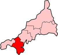
Medina was a non-metropolitan district with the status of a borough on the Isle of Wight in England from 1974 to 1995.

Cambridgeshire and Isle of Ely was, from 1965 to 1974, an administrative and geographical county in East Anglia in the United Kingdom. In 1974 it became part of an enlarged Cambridgeshire.

Glanford was, from 1974 to 1996, a local government district with borough status in the non-metropolitan county of Humberside, England.
New Forest is a local government district in Hampshire, England. Its council is based in Lyndhurst, although the largest town is Totton. The district also includes the towns of Fordingbridge, Lymington, New Milton and Ringwood. The district is named after and covers most of the New Forest National Park, which occupies much of the central part of the district. The main urban areas are around the periphery of the forest. The district has a coastline onto the Solent to the south and Southampton Water to the east.

Kingswood was, from 1974 to 1996, a non-metropolitan district of the county of Avon, England.

The Local Government Act 1972 is an act of the Parliament of the United Kingdom that reformed local government in England and Wales on 1 April 1974. It was one of the most significant Acts of Parliament to be passed by the Heath Government of 1970–74.
A non-metropolitan county, or colloquially, shire county, is a subdivision of England used for local government.

Isle of Wight Council, known between 1890 and 1995 as Isle of Wight County Council, is the local authority for the Isle of Wight in England. Since 1995 it has been a unitary authority, being a county council which also performs the functions of a district council. It is based at County Hall in Newport. The council has been under no overall control since 2021, being led by a coalition of independent, Green, and Our Island councillors called the Alliance Group.

South Hampshire is a term used mainly to refer to the conurbation formed by the city of Portsmouth, city of Southampton and the non-metropolitan boroughs of Gosport, Fareham, Havant and Eastleigh in southern Hampshire, South East England. The area was estimated to have a population of over 1.5 million in 2013. It is the most populated part of South East England excluding London. The area is sometimes referred to as Solent City particularly in relation to local devolution, but the term is controversial.
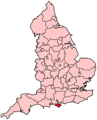
As a geographical entity distinct from the mainland, the Isle of Wight has always fought to have this identity recognised. The Isle of Wight is currently a ceremonial and Non-metropolitan county and local government is controlled by unitary authority. Prior to the 2024 United Kingdom General election, the island was the highest populated Westminster constituency in the country.
Isle of Wight was a constituency that was last represented in the House of Commons of the UK Parliament from 2017 until 2024 by Bob Seely, a Conservative.

The unitary authorities of England are a type of local authority responsible for all local government services in an area. They combine the functions of a non-metropolitan county council and a non-metropolitan district council, which elsewhere in England provide two tiers of local government.
The Local Government Commission for England was the body responsible for reviewing the structure of local government in England from 1992 to 2002. It was established under the Local Government Act 1992, replacing the Local Government Boundary Commission for England. The Commission could be ordered by the Secretary of State to undertake "structural reviews" in specified areas and recommend the creation of unitary authorities in the two-tier shire counties of England. The Commission, chaired by John Banham, conducted a review of all the non-metropolitan counties of England from 1993 to 1994, making various recommendations on their future.

