Southgate Town Hall

Last updated

Southgate Town Hall
Prytaneum Court, former Southgate Town Hall, 251 Green Lanes, London.JPG
Southgate Town Hall
Location Palmers Green
Coordinates 51°36′55″N0°06′37″W / 51.6154°N 0.1102°W / 51.6154; -0.1102 Coordinates: 51°36′55″N0°06′37″W / 51.6154°N 0.1102°W / 51.6154; -0.1102
Built1893
ArchitectArthur Rowland Barker
Architectural style(s) Queen Anne style
Enfield London UK location map.svg
Red pog.svg
Shown in Enfield

Southgate Town hall is a municipal building in Green Lanes, Palmers Green, London.

Contents

History

The building was commissioned by the local board of health as dedicated municipal offices in anticipation of Southgate becoming an urban district in 1894. [1] The site they selected was agricultural land associated with Bowes Farm. [2]

The municipal offices, the northern section of the current complex, were designed by Arthur Rowland Barker in the Queen Anne style and completed in 1893. [3] The design involved an asymmetrical main frontage with five bays facing onto Green Lanes; there was a porch in the middle of the building and the right hand two bays projected forwards and there were rows of sash windows on the ground floor and first floor. [1] In 1914, the building was extended southwards by adding another five bays: this time the left hand two bays projected forward to achieve a symmetrical composition, and a clock tower was added on the roof. [3] The principal room in the extension was the new council chamber. [1] A stone name plaque bearing the coat of arms of the borough with the words "Southgate Town Hall" below was erected on the front elevation of the building. [3]

The building became the headquarters of the Municipal Borough of Southgate when the area was granted municipal borough status in 1933. A public library, which subsequently became known as "Palmers Green library", was erected to the north west of the main building in April 1940. [3] The town hall served as the local Civil Defence Control Centre during the Second World War. [1] Princess Alexandra, who had already visited the building as a child, visited it again in 1961. [1]

The building ceased to function as the local of seat of government when the enlarged London Borough of Enfield was formed in 1965. [4] It was subsequently used as the Local History Archive until 2009 when it was deemed surplus to requirements and marketed for sale. [5] It was acquired by the developer, Hollybrook Homes, in November 2013 [6] [7] and conversion of the property for residential use as "Prytaneum Court" (Prytaneion is a Greek word meaning "seat of government") was completed in September 2015. [8] [9]

As part of the transaction the developer agreed to undertake a programme of refurbishment works at a cost of £4.45 million at Palmers Green Library. [10] [11] The memorials commemorating council employees who had died in the First and the Second World Wars had been recovered from the town hall before it was converted and rededicated at Palmers Green Library in January 2019. [12]

Use by media

The former town hall is used to represent Cowley police station in the drama series Endeavour . [13]

Related Research Articles

<span class="mw-page-title-main">Palmers Green</span> Human settlement in England

Palmers Green is a suburban area and electoral ward in North London, England, within the London Borough of Enfield. It is located within the N13 postcode district, around 8 miles (13 km) north of Charing Cross. It is home to the largest population of Greek Cypriots outside Cyprus and is often nicknamed "Little Cyprus" or "Palmers Greek".

<span class="mw-page-title-main">Southgate, London</span> Human settlement in England

Southgate is a suburban area of North London, England in the London Borough of Enfield. It is located around 8 miles (13 km) north of Charing Cross. The name is derived from being the south gate to Enfield Chase.

<span class="mw-page-title-main">London Borough of Enfield</span> Borough in United Kingdom

The London Borough of Enfield is a London borough in North London. It borders the London boroughs of Barnet to the west, Haringey to the south, and Waltham Forest to the southeast. To the north are the districts of Hertsmere, Welwyn Hatfield and Broxbourne, and to the east is Epping Forest District in Essex. The local authority is Enfield London Borough Council. Enfield's population is estimated to be 333,794; the main towns in the borough are Edmonton, Enfield, Southgate and Palmers Green. Enfield is the northernmost London borough.

Winchmore Hill is a suburb and electoral ward in the Borough of Enfield, North London, in the N21 postal district. With the Winchmore Hill conservation area as a focal point, the district is bounded on the east by Green Lanes, Barrowell Green, Firs Lane and Fords Grove, and on the north-west by Grovelands Park; in the south it extends to part of Aldermans Hill, and in the north to Vicars Moor Lane and Houndsden Road. Winchmore Hill is 8.9 miles (14.3 km) north north-east of Charing Cross.

<span class="mw-page-title-main">Enfield, London</span> Suburb of London

Enfield is a large town in North London, England, 10.1 miles (16.3 km) north of Charing Cross. It had a population of 156,858 in 2018. It includes the areas of Botany Bay, Brimsdown, Bulls Cross, Bullsmoor, Bush Hill Park, Clay Hill, Crews Hill, Enfield Highway, Enfield Lock, Enfield Town, Enfield Wash, Forty Hill, Freezywater, Gordon Hill, Grange Park, Hadley Wood, Ponders End, and World's End.

<span class="mw-page-title-main">Enfield Southgate (UK Parliament constituency)</span> UK Parliament constituency since 1950

Enfield Southgate is a constituency in the House of Commons of the UK Parliament. It was created in 1950 as Southgate, and has been represented since 2017 by Bambos Charalambous, a member of the Labour Party.

<span class="mw-page-title-main">Osidge</span> Human settlement in England

Osidge is a district in the London Borough of Barnet, between Brunswick Park and Southgate, just west of the border with the London Borough of Enfield. It may be loosely defined as the part of postal district N14 that is in Barnet. Osidge has no formal border and is entirely enclosed within the electoral ward of Brunswick Park, East Barnet; however Oak Hill Park forms a natural boundary to the North and Pymmes Brook to the West, with the A111 to the East and the Piccadilly line to the South/East.

<span class="mw-page-title-main">Edmonton, London</span> District of London, England

Edmonton is a town in north London, England within the London Borough of Enfield, a local government district of Greater London. The northern part of the town is known as Lower Edmonton or Edmonton Green, and the southern part as Upper Edmonton. Situated 8.4 miles (13.5 km) north-northeast of Charing Cross, it borders Enfield to the north, Chingford to the east, and Tottenham to the south, with Palmers Green and Winchmore Hill to the west. The population of Edmonton was 82,472 as of 2011.

<span class="mw-page-title-main">Municipal Borough of Southgate</span>

Southgate was a local government district of Middlesex from 1881 to 1965. It was part of the London postal district and Metropolitan Police District.

<span class="mw-page-title-main">Municipal Borough of Edmonton</span>

Edmonton was a local government district in north-east Middlesex, England, from 1850 to 1965.

<span class="mw-page-title-main">Parks and open spaces in the London Borough of Enfield</span>

The London Borough of Enfield is the northernmost of the Outer London boroughs. The borough lies within the Metropolitan Green Belt, and several of its 123 or more parks and open spaces are part of it. The ancient Enfield Chase, remnants of which still exist, occupied much of the area. In addition to many playgrounds and sports facilities, the main areas of public open space are:

Southgate School is a coeducational secondary school and sixth form located in the Oakwood area of London, England.

<span class="mw-page-title-main">The Fox, Palmers Green</span>

The Fox is a public house in Palmers Green, north London, on the corner of Green Lanes and Fox Lane. A Fox pub and hotel has stood on the site for over 300 years. In 2004, The Fox featured in the film of J.K. Rowling's novel Harry Potter and the Prisoner of Azkaban. In 2015, The Fox was the first Asset of Community Value to be registered in the London Borough of Enfield.

<span class="mw-page-title-main">Enfield Civic Centre</span> Municipal building in London, England

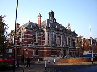
Enfield Civic Centre is a municipal building in Silver Street, Enfield, London. It is the headquarters of Enfield London Borough Council.

<span class="mw-page-title-main">Tottenham Town Hall</span> Municipal building in London, England

Tottenham Town Hall is a municipal building in Town Hall Approach Road, Tottenham, London. It is a Grade II listed building.

<span class="mw-page-title-main">Stratford Town Hall</span> Municipal building in London, England

Stratford Town Hall is a municipal building in Stratford, London. It is a Grade II listed building.

<span class="mw-page-title-main">Chingford Town Hall</span> Municipal building in London, England

Chingford Town Hall is a municipal building in The Ridgeway, Chingford, London. It is a locally listed building.

<span class="mw-page-title-main">Wandsworth Town Hall</span> Municipal building in London, England

Wandsworth Town Hall is a municipal building on the corner of Wandsworth High Street and Fairfield Street in Wandsworth, London. The building, which is the headquarters of Wandsworth London Borough Council, is a Grade II listed building.

<span class="mw-page-title-main">Anerley Town Hall</span> Municipal building in London, England

Anerley Town Hall is a municipal building in Anerley Road, Anerley, London. It is a locally listed building.

<span class="mw-page-title-main">Hanley Town Hall</span> Municipal building in Hanley, Staffordshire, England

Hanley Town Hall is a municipal building in Albion Square in Hanley, Staffordshire, England. The building, which is used as the local register office, is a Grade II listed building.

References

  1. 1 2 3 4 5 Galili, Ruby. "Southgate Town Hall". Archived from the original on 18 August 2013. Retrieved 25 April 2020.
  2. "Ordnance Survey Map". 1883. Retrieved 1 May 2020.
  3. 1 2 3 4 "London's Town Halls". Historic England. p. 60. Retrieved 25 April 2020.
  4. "Local Government Act 1963". Legislation.gov.uk. Retrieved 25 April 2020.
  5. "Southgate Town Hall: Supplementary Planning Document" (PDF). London Borough of Enfield. 1 October 2011. Retrieved 25 April 2020.
  6. "Southgate Town Hall". EGI. 20 November 2013. Retrieved 1 May 2020.
  7. "Southgate Town Hall has been sold to housing developers to become flats". Enfield Independent. 19 November 2013. Retrieved 1 May 2020.
  8. "Prytaneum Court, 251 Green Lanes, London". Winkworth. Retrieved 1 May 2020.
  9. "Southgate Town Hall". BPPCC. Retrieved 1 May 2020.
  10. "Southgate Town Hall deal agreed". Opportunity Enfield. 22 November 2013. Retrieved 1 May 2020.
  11. "Palmers Green library". The New Wipers Times. 1 January 2020. Retrieved 1 May 2020.
  12. "Re-dedication of the Southgate Town Hall War Memorials". 29 January 2019. Retrieved 1 May 2020.
  13. "Town Hall of many disguises". Palmers Green Jewel in the North. 4 October 2012. Retrieved 2 March 2023.