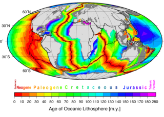
Seafloor spreading is a process that occurs at mid-ocean ridges, where new oceanic crust is formed through volcanic activity and then gradually moves away from the ridge.
A transform fault or transform boundary, sometimes called a strike-slip boundary, is a fault along a plate boundary where the motion is predominantly horizontal. It ends abruptly where it connects to another plate boundary, either another transform, a spreading ridge, or a subduction zone. A transform fault is a special case of a strike-slip fault that also forms a plate boundary.

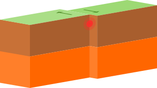
In plate tectonics, a divergent boundary or divergent plate boundary is a linear feature that exists between two tectonic plates that are moving away from each other. Divergent boundaries within continents initially produce rifts, which eventually become rift valleys. Most active divergent plate boundaries occur between oceanic plates and exist as mid-oceanic ridges. Divergent boundaries also form volcanic islands, which occur when the plates move apart to produce gaps that magma rises to fill.

The North American Plate is a tectonic plate covering most of North America, Cuba, the Bahamas, extreme northeastern Asia, and parts of Iceland and the Azores. With an area of 76 million km2 (29 million sq mi), it is the Earth's second largest tectonic plate, behind the Pacific Plate.

The Explorer Plate is an oceanic tectonic plate beneath the Pacific Ocean off the west coast of Vancouver Island, Canada, which is partially subducted under the North American Plate. Along with the Juan De Fuca Plate and Gorda Plate, the Explorer Plate is a remnant of the ancient Farallon Plate, which has been subducted under the North American Plate. The Explorer Plate separated from the Juan De Fuca Plate roughly 4 million years ago. In its smoother, southern half, the average depth of the Explorer plate is roughly 2,400 metres (7,900 ft) and rises up in its northern half to a highly variable basin between 1,400 metres (4,600 ft) and 2,200 metres (7,200 ft) in depth.

The Scotia Plate is a tectonic plate on the edge of the South Atlantic and Southern oceans. Thought to have formed during the early Eocene with the opening of the Drake Passage that separates South America from Antarctica, it is a minor plate whose movement is largely controlled by the two major plates that surround it: the South American Plate and the Antarctic Plate.

A fracture zone is a linear oceanic feature—often hundreds, even thousands of kilometers long—resulting from the action of offset mid-ocean ridge axis segments. They are a consequence of plate tectonics. Lithospheric plates on either side of an active transform fault move in opposite directions; here, strike-slip activity occurs. Fracture zones extend past the transform faults, away from the ridge axis; seismically inactive, they display evidence of past transform fault activity, primarily in the different ages of the crust on opposite sides of the zone.

The Diamantina Fracture Zone is an area of the south-eastern Indian Ocean seafloor. It has a range of ridges and trenches. It lies to the south of the mideastern Indian Ocean features of the Wharton Basin and Perth Basin, and to the south west of the Naturaliste Plateau.

The Mendocino Fracture Zone is a fracture zone and transform boundary over 4000 km long, starting off the coast of Cape Mendocino in far northern California. It runs westward from a triple junction with the San Andreas Fault and the Cascadia subduction zone to the southern end of the Gorda Ridge. It continues on west of its junction with the Gorda Ridge, as an inactive remnant section which extends for several hundred miles.

The Explorer Ridge is a mid-ocean ridge, a divergent tectonic plate boundary located about 241 km (150 mi) west of Vancouver Island, British Columbia, Canada. It lies at the northern extremity of the Pacific spreading axis. To its east is the Explorer Plate, which together with the Juan de Fuca Plate and the Gorda Plate to its south, is what remains of the once-vast Farallon Plate which has been largely subducted under the North American Plate. The Explorer Ridge consists of one major segment, the Southern Explorer Ridge, and several smaller segments. It runs northward from the Sovanco Fracture Zone to the Queen Charlotte Triple Junction, a point where it meets the Queen Charlotte Fault and the northern Cascadia subduction zone.

The Azores–Gibraltar Transform Fault (AGFZ), also called a fault zone and a fracture zone, is a major seismic zone in the Eastern Atlantic Ocean between the Azores and the Strait of Gibraltar. It is the product of the complex interaction between the African, Eurasian, and Iberian plates. The AGFZ produced the large-magnitude 1755 Lisbon, 1761, 1816, 1941 Gloria Fault earthquake, 1969 Horseshoe and 1975 earthquakes and, consequently, a number of large tsunamis.

The Owen Fracture Zone (OFZ), though misnamed a fracture zone, is a transform fault in the northwest Indian Ocean that separates the Arabian and African Plates from the Indian Plate. Extending north-northeast from where the Carlsberg Ridge meets the Sheba ridge in the south to the Makran Subduction Zone in the north, it represents the port side of the northward motion of the Indian subcontinent during the Late Cretaceous–Palaeogene break-up of Gondwana. Slip along the Owen Fracture Zone is occurring at 2 mm (0.079 in)/yr, the slowest rate on Earth, which means the Arabian Plate moves northward faster than the Indian Plate.
The Aden-Owen-Carlsberg Triple Junction (AOC), also known as the Arabia–India–Somalia Triple Junction, is a triple junction that connects the Aden Ridge, Owen Fracture Zone, and Carlsberg Ridge in the northwest Indian Ocean. It has been described as one of only three RRF (ridge-ridge-fault) triple junctions on Earth, besides the Azores Triple Junction and Chile Triple Junction. However, because the fault arm of such unstable triple junctions tend to evolve into a spreading centre, all three cases have quickly evolved into stable RRR triple junctions.
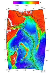
The Central Indian Ridge (CIR) is a north-south-trending mid-ocean ridge in the western Indian Ocean.
The Tehuantepec Ridge is a linear undersea ridge located off the west coast of Mexico in the Pacific Ocean. It is the remnant of an old fracture zone, and not a tectonic spreading center ridge. It extends from the eastern end of the Clipperton Fracture Zone northeastward toward Mexico into Chiapas and El Chichón until it is subducted into the Middle America Trench. It lies within the tectonic Cocos Plate, separating the lower and older seafloor of the Guatemala Basin which lies southeast of the ridge from higher and younger seafloor which lies to its northwest.

The Jan Mayen Microcontinent is a fragment of continental crust within the oceanic part of the western Eurasian Plate lying northeast of Iceland. At the onset of separation between the Greenland and Eurasian plates 55 million years ago, it formed part of the eastern margin of the Greenland Plate. Propagation of a new spreading center from the Reykjanes Ridge separated this microcontinent from the Greenland Plate. For a short period it formed a microplate, until the Aegir Ridge became inactive, after which it formed part of the Eurasian Plate. The island of Jan Mayen is a much younger feature, formed of volcanic rock, built up at the northernmost tip of the microcontinent.

The Vema Fracture Zone is a fracture zone in the equatorial Atlantic Ocean. It offsets the Mid-Atlantic Ridge by 320 km to the left. Its transform valley has a depth of 5000m. The fracture zone can be traced for over 2500 km east to west.

The Agulhas Basin is an oceanic basin located south of South Africa where the South Atlantic Ocean and south-western Indian Ocean meet. Part of the African Plate, it is bounded by the Agulhas Ridge to the north and the Southwest Indian Ridge to the south; by the Meteor Rise to the west and the Agulhas Plateau to the east. Numerous bathymetric anomalies hint at the basin's dynamic tectonic history.

The geological deformation of Iceland is the way that the rocks of the island of Iceland are changing due to tectonic forces. The geological deformation explains the location of earthquakes, volcanoes, fissures, and the shape of the island. Iceland is the largest landmass (102,775 km²) situated on an oceanic ridge. It is an elevated plateau of the sea floor, situated at the crossing of the Mid-Atlantic Ridge and the Greenland-Iceland-Faeroe Ridge. It lies along the oceanic divergent plate boundary of North American Plate and Eurasian Plate. The western part of Iceland sits on the North American Plate and the eastern part sits on the Eurasian Plate. The Reykjanes Ridge of the Mid-Atlantic ridge system in this region crosses the island from southwest and connects to the Kolbeinsey Ridge in the northeast.
