Kentucky Route 676 is a Kentucky State Highway located almost entirely within the city limits of Frankfort. The four-lane divided highway is locally known as the East–West Connector.

Kentucky Route 90 is a major east-west state highway in southern Kentucky. The route is 134.734 miles (216.833 km) long, and it traverses Barren, Metcalfe, Cumberland, Clinton, Wayne, Pulaski, McCreary and Whitley Counties in southern Kentucky. It originates near the KY 70 junction with Interstate 65 in Cave City and ends at a junction with US 25W at Youngs Creek.
Kentucky Route 70 (KY 70) is a long east-east state highway that originates at a junction with U.S. Route 60 (US 60) in Smithland in Livingston County, just east of the Ohio River. The route continues through the counties of Crittenden, Caldwell, Hopkins, Muhlenberg, Butler, Edmonson, Barren, Barren, Metcalfe, Green, Taylor, Casey, Pulaski, Lincoln and back into Pulaski again to terminate at a junction with US 150 near Maretburg in Rockcastle.
Kentucky Route 101 (KY 101) is a north–south highway traversing three counties in south central Kentucky.
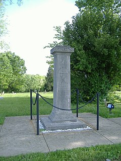
The Colored Soldiers Monument in Frankfort, Kentucky's Green Hill Cemetery, at the junction of US 60 and US 421, is the only Kentucky monument to black soldiers that participated in the American Civil War, and one of only four in the entire United States. The GAR Monument in Covington is the only other monument built by the Grand Army of the Republic in the state of Kentucky.
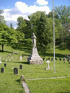
The Confederate Monument in Frankfort, in Frankfort Cemetery in Frankfort, Kentucky, is a monument dedicated to the Confederate States of America that is on the National Register of Historic Places.
U.S. Route 421 (US 421) in the U.S. state of Kentucky is a 250.536-mile-long (403.199 km) north–south United States highway that traverses twelve counties in the central and eastern parts of the state. It travels in a southeast-to-northwest path from the Virginia state line near Pennington Gap to the Indiana state line, on the Ohio River at Milton, Kentucky and Madison, Indiana.
Kentucky Route 1508 is a state highway located in northwestern Kentucky. The route starts at KY 109, west of Sturgis. It travels westward to unincorporated area of Caseyville, and turns north near the Ohio River. KY 1508 then travels through the community of Dekoven, before ending at KY 109, northwest of its southern terminus. The route was designated around 1967, after the KY 130 designation was removed from the section in Caseyville, which was connected to the community since 1939.
Veterans Outer Loop is a major bypass route in Glasgow, Kentucky. It is maintained by the Kentucky Transportation Cabinet (KYTC).
Kentucky Route 221 (KY 221) is a 42.5-mile-long (68.4 km) state highway in the U.S. state of Kentucky. The highway connects mostly rural areas of Bell, Harlan, Perry, and Leslie counties with the Daniel Boone National Forest.
The Russellville Bypass is a beltway around Russellville in Logan County in south central Kentucky. The 12.260-mile-long (19.731 km) highway comprises overlapping portions of U.S. Route 68 and Kentucky Route 80, US 79, and US 431. The north side of the circumferential highway was conceived in the 1980s to relieve traffic in downtown Russellville and as part of greater improvements along the US 68 corridor. The first two phases of the ring road, from US 79 on the west side to US 68 on the east side, were constructed in the 1990s. The state decided to complete the orbital road in the 2000s to resolve continuing traffic bottlenecks along US 431 and US 79 on the south side. The second two phases of the beltline were started in 2010 and completed in 2017. Construction of the Russellville Bypass led to a series of route changes over 20 years involving the city's U.S. Highways, special routes, and state-numbered highways.
Kentucky Route 1020 is a 17.806-mile-long (28.656 km) north–south state highway in north central Kentucky, traversing portions of Bullitt and Jefferson counties, including the Louisville metropolitan area.
Kentucky Route 864 is a 16.339-mile-long (26.295 km) state highway located entirely in the Louisville metropolitan area of Jefferson County in north central Kentucky.
