This article needs additional citations for verification .(January 2017) |
Special routes of U.S. Route 4 | |
|---|---|
| Highway system | |
A total of at least five special routes of U.S. Route 4 (US 4) have existed.
This article needs additional citations for verification .(January 2017) |
Special routes of U.S. Route 4 | |
|---|---|
| Highway system | |
A total of at least five special routes of U.S. Route 4 (US 4) have existed.
| | This section is empty. You can help by adding to it. (July 2013) |
| Location | Fair Haven–West Rutland, Vermont |
|---|---|
| Location | Rutland, Vermont |
|---|---|
| Length | 4.371 mi [1] (7.034 km) |
U.S. Route 4 Business (US 4 Bus.) is a 4.371-mile (7.034 km) [1] alternate route of US 4 serving the city of Rutland, Vermont, and running north of US 4. It begins at exit 6 of the US 4 expressway in West Rutland and heads north to Main Street in West Rutland center, where it meets the east end of Vermont Route 4A (VT 4A). US 4 Bus. turns east, following Main Street into the town of Rutland. In the town of Rutland, the road changes names to Rutland Road and intersects with VT 3 at the town center. About 0.3 miles (0.48 km) later, the road enters the city of Rutland, becoming West Street. US 4 Bus. briefly shifts north one block to use State Street before returning to West Street after half a mile (0.80 km). The route ends at an intersection with US 4 and US 7 in the center of the city.
| | This section is empty. You can help by adding to it. (July 2013) |
| Location | Andover–Boscawen, New Hampshire |
|---|---|
| | This section is empty. You can help by adding to it. (July 2013) |
| Location | Concord, New Hampshire |
|---|---|
| | This section is empty. You can help by adding to it. (July 2013) |
| Location | East Northwood–Dover, New Hampshire |
|---|---|

Rutland County is a county located in the U.S. state of Vermont. As of the 2020 census, the population was 60,572, making it the second-most populous county in Vermont. Its county seat and most populous municipality is the city of Rutland.

Middlebury is the shire town of Addison County, Vermont, United States. As of the 2020 census, the population was 9,152. Middlebury is home to Middlebury College and the Henry Sheldon Museum of Vermont History.

Manchester is a town in, and one of two shire towns of, Bennington County, Vermont, United States. The population was 4,484 at the 2020 census.
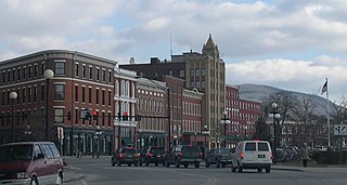
Rutland is the only city in and the seat of Rutland County, Vermont, United States. As of the 2020 census, the city had a total population of 15,807. It is located approximately 65 miles (105 km) north of the Massachusetts state line, 35 miles (56 km) west of New Hampshire state line, and 20 miles (32 km) east of the New York state line. Rutland is the third largest city in the state of Vermont after Burlington and South Burlington. Rutland City is completely surrounded by Rutland Town, which is a separate municipality. The downtown area of the city is listed as a historic district on the National Register of Historic Places.

U.S. Route 4 (US 4) is a 253-mile-long (407 km) United States Numbered Highway that runs from East Greenbush, New York, in the west to Portsmouth, New Hampshire, in the east, traversing Vermont.

Vermont Route 105 (VT 105) is a 98.135-mile-long (157.933 km) state highway located in northern Vermont in the United States. The route runs from U.S. Route 7 (US 7) in St. Albans in the west to the New Hampshire state line in Bloomfield in the east. The road continues across the state line as Bridge Street, a short unnumbered New Hampshire state route to US 3 in North Stratford, New Hampshire. As it is not a New Hampshire state highway, the connection is signed with Vermont state highway signage, similar to how connections to Vermont state routes are indicated elsewhere in New Hampshire.
Vermont Route 11 is a 42.154-mile-long (67.840 km) east–west state highway in Vermont, United States. The western end of the highway is at VT 7A in Manchester. The eastern end is at the New Hampshire border at the Cheshire Bridge over the Connecticut River, connecting Springfield and Charlestown, New Hampshire. The route continues into New Hampshire as New Hampshire Route 11, and then following that into Maine as Maine State Route 11. The three Routes 11, totaling 551.7 miles (887.9 km) in length, were once part of the New England Interstate system.
Vermont Route 22A (VT 22A) is a 44.738-mile-long (71.999 km) state highway in western Vermont, United States. It is the northward continuation of New York State Route 22A. Its southern end is at the New York state line in Fair Haven and its northern end is in Ferrisburgh at U.S. Route 7 (US 7). As it is an extension of NY 22A, VT 22A is a spur route of NY 22, which runs roughly parallel to VT 22A west of the state border. This is a rather unusual case of one state having a suffixed route of another state's primary route. Vermont does not currently have a "Route 22."

Vermont Route 15 (VT 15) is a 68.957-mile-long (110.976 km) east–west state highway in northern Vermont, United States. Its western terminus is at U.S. Route 2 (US 2) and US 7 in Winooski and its eastern terminus is at US 2 in Danville. It is known as the Grand Army of the Republic Highway, a designation shared nationally with U.S. Route 6.
Vermont Route 14 (VT 14) is a 108.946-mile-long (175.332 km) north–south state highway in northeastern Vermont, United States. It extends from U.S. Route 4 (US 4) and US 5 in White River Junction to VT 100 in Newport. Between White River Junction and the city of Barre, the route parallels Interstate 89 (I-89). VT 14 was originally designated in 1922 as part of the New England road marking system. Its north end was truncated in 1926 as a result of the designation of US 2 but was extended north along an old alignment of VT 12 in the 1960s.

Vermont Route 9 is a state highway in the U.S. state of Vermont. The highway runs 46.957 miles (75.570 km) from the New York state line in Bennington, where it continues west as New York State Route 7, to the New Hampshire state line at the Connecticut River in Brattleboro, where the highway continues as New Hampshire Route 9. VT 9 is the primary east–west highway of Bennington and Windham counties in southern Vermont. The highway connects Southern Vermont's primary towns of Bennington and Brattleboro via its crossing of the Green Mountains. VT 9 also connects those towns with Troy, New York, and Keene, New Hampshire, via the connecting highways in those states. The highway also intersects three major north–south routes: U.S. Route 7 in Bennington and Interstate 91 (I-91) and US 5 in Brattleboro.

Vermont Route 133 (VT 133) is a 22.476-mile-long (36.172 km) north–south state highway in Rutland County, Vermont, United States. It runs from VT 30 in Pawlet in the south to VT 4A in West Rutland in the north.

Vermont Route 4A (VT 4A) is a 14.174-mile-long (22.811 km) east–west state highway in Rutland County, Vermont, United States. It runs from Fair Haven to West Rutland. VT 4A was the former alignment of U.S. Route 4 before it was relocated to an expressway.
Vermont Route 114 (VT 114) is a 53.094-mile-long (85.447 km) north–south state highway in northeastern Vermont in the United States. It runs northward from U.S. Route 5 (US 5) in Lyndon until nearing the Canada–United States border in the town of Norton; thereafter, the road continues east to the New Hampshire state line in Canaan. The vast majority of VT 114 is situated within Essex County; however, the route also passes through small, isolated portions of Caledonia and Orleans Counties.

U.S. Route 4 (US 4) in the U.S. state of Vermont extends for 66.059 miles (106.312 km) between the New York state line at Fair Haven and the New Hampshire state line at White River Junction. It is one of the main arteries between New York and New Hampshire.

U.S. Route 7 (US 7) is a north–south highway extending from southern Connecticut to the northernmost part of Vermont. In Vermont, the route extends for 176 miles (283 km) along the western side of the state as a mostly two-lane rural road, with the exception of an expressway section between Bennington and East Dorset. US 7 is known as the Ethan Allen Highway for its entire length through the state, named after the US Revolutionary War general. US 7 ends at an interchange with Interstate 89 (I-89) in the town of Highgate, just south of the Canada–United States border. I-89 continues to the border crossing.

There are a number of special routes of U.S. Route 2 (US 2). These special routes connect US 2 to downtown areas, bypass city centers, or provide alternate routes around an area.

Vermont Route 104 (VT 104) is a state highway in the U.S. state of Vermont. The highway runs 20.503 miles (32.996 km) from VT 15 in Cambridge to VT 105 in the town of St. Albans. VT 104 is an L-shaped route that connects the city of St. Albans and Cambridge via Fairfax. The highway has an auxiliary route, VT 104A, that connects Fairfax and Georgia to the west.
Vermont Route 140 (VT 140) is a state highway in the U.S. state of Vermont. The highway runs 25.059 miles (40.329 km) from VT 30 in Poultney east to VT 103 in Mount Holly. VT 140 connects the southern Rutland County towns of Poultney, Middletown Springs, Tinmouth, Wallingford, and Mount Holly.
Castleton Four Corners is a census-designated place (CDP) in the town of Castleton, Rutland County, Vermont, United States. It consists of the unincorporated villages of Castleton Corners and Hydeville. As of the 2020 census, the CDP had a population of 699, out of 4,458 in the entire town.