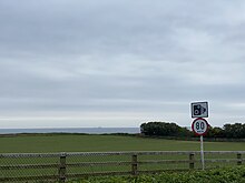
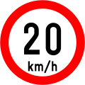
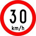
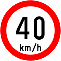
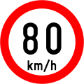
Speed limits in Ireland apply on all public roads in the state. These are signposted and legislated for in kilometres per hour. Speed limits are demarcated by regulatory road signs. These consist of white circular signs with a red outline. Speed limits are marked in black with "km/h" below the speed limit. Smaller "repeater" speed limit signs are used along stretches of road where there is no change in speed limit, in order to remind motorists currently on the road and to inform traffic merging from junctions that a certain speed limit applies.
The first speed limits in Ireland were introduced prior to independence, by regulations made in 1876 under the Dublin Traffic Act 1875, which prescribed speed limits of 6 mph (9.7 km/h) for certain vehicles. The Light Locomotives on Highways (Ireland) Order 1896 then set a maximum national speed limit of 12 mph (19 km/h) with a speed limit of 6 mph (9.7 km/h) for traffic in villages, towns and the Dublin Metropolitan Police District. Vehicles weighing more than 2 tons (unladen) were restricted to 5 mph (8.0 km/h) in these areas. This situation was updated in 1933 with Road Traffic Act 1933 [1] prescribing an ordinary speed limit of 25 mph (40 km/h) for light motor vehicles or heavy motor vehicles fitted with pneumatic tyres. Lower speed limits were applied for heavy motor vehicles without some pneumatic tyres, or used for pulling another vehicle. Road signage was established by the Traffic Signs Regulations, 1956. [2]
However, the main piece of legislation responsible for the introduction of speed limits in Ireland was Part IV of the Road Traffic Act, 1961. [3] This repealed the 1933 Act and allowed the Minister for the Environment to prescribe a general speed limit through regulations made under this Act. It also allowed local authorities to specify special speed limits through regulations made under this Act. The first regulations made were the Road Traffic (Speed Limits) Regulations, 1963 [4] which set down a speed limit of 50 mph (80 km/h) for all roads except those subject to a built up area speed limit of 30 mph (48 km/h) or special speed limit of 40 mph (64 km/h). Throughout the mid to late 1960s local authorities studied roads in their areas and had regulations drafted specifically for their county which prescribed speed limits of 30 mph (48 km/h) and 40 mph (64 km/h) along specifically named roads in their administrative area.
On 1 April 1969 the Minister for the Environment through the Road Traffic (General Speed Limit) Regulations, 1969 [5] finally prescribed a general national speed limit of 60 mph (97 km/h) on all roads except those subject to special and built up area speed limits of 40 mph (64 km/h) and 30 mph (48 km/h). This replaced the 50 mph (80 km/h) speed limit in all but a few cases where regulations had been drafted specifically to impose a 50 mph (80 km/h) limit. While the built up area and special speed limits were clearly indicated to motorists by the number 30, 40 or 50 in black numbers on a white circular background with a red outline, there was no such signage for the general 60 mph (97 km/h) speed limit. This was indicated to motorists by a "general speed limit" applies sign which consisted of a circular white sign with a black diagonal line bisecting it. The general limit was reduced to 55 mph (89 km/h) in 1979 [6] as an energy conservation measure during the 1979 energy crisis. [7] Some drivers remained unaware of this change. [8] A review of speed limits from 1990 to 1992 restored the 60 mph limit. [9] [10]
It was not until 1992 that a 70 mph (113 km/h) speed limit was authorised on the State's motorways. This occurred through the Road Traffic (Speed Limits) (County of Kildare) (Amendment) Regulations, 1992 [11] and the similar Road Traffic (Speed Limits) (County Borough of Dublin and County of Dublin) (Amendment) Regulations, 1992. [12] This authorised traffic on the M1, M7, M11 and M50 to travel at 70 mph (113 km/h) where signposted. This was extended to motorways in general by the Road Traffic Act, 1994. [13] A minimum speed limit of 30 mph (48 km/h) had previously been set in 1974.[ citation needed ]
On 20 January 2005, Ireland adopted metric speed limits. [14] Around 35,000 existing signs were replaced and a further 23,000 new signs erected bearing the speed limit in kilometres per hour. To avoid confusion with the old signs, each speed limit sign now has "km/h" beneath the numerals.
In February 2012 Leo Varadkar, the Minister for Transport, Tourism and Sport, tasked a working group with reviewing speed-limit policy and implementation. [15] Its report, published in 2013, identified two key issues: inconsistency of limits between similar roads, and inappropriateness of limits on some roads. [16] It found the default limits were unsafely high on many minor roads where they applied. It recommended the introduction of a "rural speed limit" sign, to emphasise that the statutory maximum speed was not necessarily a safe speed. The Rural Speed Limit Sign (RUS 041A) consists of a 450mm diameter white disk with a black border and oblique parallel black bars (not to be confused with the 'end of speed limit' sign in existence in Ireland prior to the 2004 Road Traffic Act, nor the 'end of previously signed restrictions' sign used in mainland Europe). This was introduced in 2015 with the publication of the Guidelines for Setting and Managing Speed Limits in Ireland (The Guidelines [17] ) as a combination of Sign RUS 041A and Plate P 080 (bilingually reading SLOW and Go Mall); it can only be used on single-lane local tertiary roads and selected single-lane local secondary roads and not on national, regional, or local primary roads. [18]
Different default speed limits apply to particular categories of roads. Default speed limits are termed as "ordinary speed limits" by the Road Traffic Act 2004. There are also speed restrictions for certain classes of vehicles. As of 2007, the ordinary speed limits are as follows:
There are particular powers available to local county councils under the Road Traffic Act 2004 [19] to apply "special speed limits" to particular stretches of road. Special speed limits of 30, 50, 60, 80, 100 and 120 km/h (19, 31, 37, 50, 62 and 75 mph) can be imposed, but only 30 and 60 km/h (19 and 37 mph) are exclusively "special" as opposed to the others which are "ordinary". The 120 km/h (75 mph) limit is ordinary for motorways but can be special for dual carriageways forming part of a national primary road. Special speed limits are usually lower than normal, for schools, etc. One instance of higher speed limits being applied is that of the new N2 route from the M50 motorway in Fingal (Dublin) to north of Ashbourne, County Meath where a special speed limit of 120 km/h (75 mph) was imposed from 15 June 2006, therefore becoming the first non-motorway road in Ireland to obtain this speed limit. According to the project engineers, the National Roads Authority decided due to the lack of available space at the M50 junction to accommodate a parallel joining non-motorway route that they would designate the new road as high-quality dual carriageway and block off the existing road from the M50. The 2004 Act has therefore allowed local authorities to get around such issues as the implications of motorway restrictions on learner drivers as under this act such drivers are now permitted to travel at speeds up to 120 km/h (75 mph) on such roads as this section of the N2. The N1 dual carriageway north of Dundalk has also recently been granted a special speed limit of 120 km/h (75 mph), in line with its preceding M1 motorway. As of 2 March 2007, Cork County Council and Limerick city and county councils have published amendments to local bye-laws to adjust several High Quality Carriageways' speed limits to 120 km/h (75 mph). [20] S.I. No. 331 of 2012 allowed a new speed limit of 40 km/h (25 mph) to be applied by a city or county council. [21]
The Minister for Transport issued a direction to road authorities under section 95(16) of the Road Traffic Act 1961 in February 2007 with respect to a range of non-regulatory traffic signs. Chapter 8 of the Traffic Signs Manual was superseded by an updated version which allowed for the erection of signage stating a cautionary speed limit in the vicinity of road works. These speed limits are purposely different from legally enforceable speed limits and always display a speed limit that ends in 5; they are – 25 km/h (16 mph), 35 km/h (22 mph), 45 km/h (28 mph), 55 km/h (34 mph), 65 km/h (40 mph) and 75 km/h (47 mph). They are not legally binding on motorists or legally enforceable by the Garda Síochána and it is not known if 'compliance' with these Cautionary speed limits is taken into account in the event of a road traffic collision, however, motorists must always drive at a speed appropriate to the prevailing conditions whilst not exceeding the speed limit. [22]
The manager of a city or county council can reduce the speed limit on a road undergoing road works for a stated period of time by executive order under powers available to them under the Road Traffic Act 2004. The reduced speed limits are typically 30, 50 or 90 km/h (19, 31 or 56 mph). These are different from cautionary speed limits as they are binding on drivers and it is an offence to exceed a road works speed limit.
Speed limits on road traffic, as used in most countries, set the legal maximum speed at which vehicles may travel on a given stretch of road. Speed limits are generally indicated on a traffic sign reflecting the maximum permitted speed, expressed as kilometres per hour (km/h) or miles per hour (mph) or both. Speed limits are commonly set by the legislative bodies of national or provincial governments and enforced by national or regional police and judicial authorities. Speed limits may also be variable, or in some places nonexistent, such as on most of the Autobahnen in Germany.
The M50 motorway is a C-shaped orbital motorway in Dublin and the busiest motorway in Ireland. The current route was built in various sections over the course of 27 years, from 1983 to 2010. It begins at Dublin Port, running northward through the Dublin Port Tunnel and along a portion of the Airport Motorway. It then turns west at its junction with the M1, circling the northern, western and southern suburbs of Dublin, before merging with the M11 at Shankill in South East Dublin. The road forms part of European route E01.
The M1 motorway is a motorway in Ireland. It forms the large majority of the N1 national primary road connecting Dublin towards Belfast along the east of the island of Ireland. The route heads north via Swords, Drogheda and Dundalk to the Northern Irish border just south of Newry in County Armagh, where it joins the A1 road and further on, the M1 motorway in Northern Ireland. It also forms a significant part of the road connection between Dublin and the Northern Irish cities of Newry, and Lisburn. The route is part of European route E01.
The island of Ireland, comprising Northern Ireland and the Republic of Ireland, has an extensive network of tens of thousands of kilometres of public roads, usually surfaced. These roads have been developed and modernised over centuries, from trackways suitable only for walkers and horses, to surfaced roads including modern motorways. Driving is on the left-hand side of the road. The major routes were established before Irish independence and consequently take little cognisance of the border other than a change of identification number and street furniture. Northern Ireland has had motorways since 1962, and has a well-developed network of primary, secondary and local routes. The Republic started work on its motorway network in the early 1980s; and historically, the road network there was once somewhat less well developed. However, the Celtic Tiger economic boom and an influx of European Union structural funding, saw national roads and regional roads in the Republic come up to international standard quite quickly. In the mid-1990s, for example, the Republic went from having only a few short sections of motorway to a network of motorways, dual carriageways and other improvements on most major routes as part of a National Development Plan. Road construction in Northern Ireland now tends to proceed at a slower pace than in the Republic, although a number of important bypasses and upgrades to dual carriageway have recently been completed or are about to begin.
The N4 road is a national primary road in Ireland, running from Dublin to the northwest of Ireland and Sligo town. The M6 to Galway diverges from this route after Kinnegad, while the N5 to Westport diverges at Longford town. Most sections of the N4 that are motorway-standard are designated the M4 motorway.
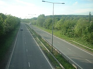
A dual carriageway (BrE) or a divided highway (AmE) is a class of highway with carriageways for traffic travelling in opposite directions separated by a central reservation (BrE) or median (AmE). Roads with two or more carriageways which are designed to higher standards with controlled access are generally classed as motorways, freeways, etc., rather than dual carriageways.
The N2 road is a national primary road in Ireland, running from Dublin to the border with Northern Ireland at Moy Bridge near Aughnacloy, County Tyrone to connect Dublin with Derry and Letterkenny via the A5. A section of the route near Dublin forms the M2 motorway.
A limited-access road, known by various terms worldwide, including limited-access highway, dual-carriageway, expressway, and partial controlled-access highway, is a highway or arterial road for high-speed traffic which has many or most characteristics of a controlled-access highway, including limited or no access to adjacent property, some degree of separation of opposing traffic flow, use of grade separated interchanges to some extent, prohibition of slow modes of transport, such as bicycles, horse-drawn vehicles or ridden horses, or self-propelled agricultural machines; and very few or no intersecting cross-streets or level crossings. The degree of isolation from local traffic allowed varies between countries and regions. The precise definition of these terms varies by jurisdiction.
Road signs in the Republic of Ireland do not differ greatly from those used elsewhere in Europe – with the notable exception that hazard or warning signs follow the 'MUTCD' style of a yellow diamond shape. The symbols used on these warning signs do, nevertheless, resemble much more closely those used in the rest of Europe than many of those seen in the United States.
The R148 road is one of Ireland's regional roads which was classified following the opening of a bypassed national primary road.
A controlled-access highway is a type of highway that has been designed for high-speed vehicular traffic, with all traffic flow—ingress and egress—regulated. Common English terms are freeway, motorway, and expressway. Other similar terms include throughway or thruway and parkway. Some of these may be limited-access highways, although this term can also refer to a class of highways with somewhat less isolation from other traffic.
Road signs in the United Kingdom and in its associated Crown dependencies and overseas territories conform broadly to European design norms, though a number of signs are unique: direction signs omit European route numbers, and road signs generally use the imperial system of units, unlike the rest of Europe. Signs in Wales and parts of Scotland are bilingual.
In the United States, speed limits are set by each state or territory. States have also allowed counties and municipalities to enact typically lower limits. Highway speed limits can range from an urban low of 25 mph (40 km/h) to a rural high of 85 mph (137 km/h). Speed limits are typically posted in increments of five miles per hour (8 km/h). Some states have lower limits for trucks, some also have night and/or minimum speed limits.
A national primary road is a road classification in Ireland. National primary roads form the major routes between the major urban centres. There are 2649 km of national primary roads. This category of road has the prefix "N" followed by one or two digits. Motorways are prefixed "M" followed by one or two digits.
A High-quality dual carriageway (HQDC) is a road category in Ireland. It is defined as an all-purpose dual carriageway road type built to near motorway standards, but without motorway classification or motorway restrictions. High-quality dual carriageways have full grade-separated access and do not have junctions with minor roads. Such roads in the Republic of Ireland have been built as part of the 2000–2006 and 2007–2013 National Development Plans, including interurban routes from Dublin to other cities.
The M6 motorway is a motorway in Ireland, which runs from Dublin to Galway. The M6 extends from its junction with the M4 at Kinnegad all the way west to the outskirts of Galway City, but the Athlone bypass and the approach to Galway city - while of dual carriageway standard - have not been designated motorway and are still signed as N6. The motorway was officially completed and opened to traffic on 18 December 2009, and was the first city-to-city direct major inter-urban route to be completed in Ireland. The M6 and M4, which form the Galway–Dublin route, consist of a grade-separated 2+2 dual carriageway road with a top speed limit of 120 km/h. At approximately 144 km (90 mi), the M6 is the third longest motorway in the state and will be 159 km.
In Ireland, the highest category of road is a motorway, indicated by the prefix M followed by a one- or two-digit number. The motorway network consists entirely of motorway-grade dual carriageways and is largely focused upon Dublin. There are also several three-lane motorways, while Ireland's busiest road, the M50, incorporates four-lane, five-lane, and six-lane stretches.
There have been routes and trackways in Ireland connecting settlements and facilitating trade since ancient times and the country now has an extensive network of public roads connecting all parts of the island.
This article describes the highway systems available in selected countries.
Road speed limits in the United Kingdom are used to define the maximum legal speed for vehicles using public roads in the UK.
This country is particularly affected by the present oil shortage ... The Government have, therefore, decided ... that the maximum speed limit on any road shall be 55 mph
Their 1992 survey showed up interesting attitudinal facts. 54 per cent of drivers correctly stated that the general speed limit was 55 miles per hour; 30 per cent believed the limit was higher than 55 miles per hour and 12 per cent believed it was less. This is an area of confusion as many people do not know the speed limit.
A comprehensive review of speed limits was carried out in Ireland between 1990 and 1992. This left urban speed limits unchanged at 30 mph and 40 mph, but increased the speed limit for heavy goods vehicles from 40 mph to 50 mph and the general speed limit from 55 mph to 60 mph.