The Northland Region is the northernmost of New Zealand's 16 local government regions. New Zealanders sometimes refer to it as the Winterless North because of its mild climate all throughout the year. The major population centre is the city of Whangārei, and the largest town is Kerikeri. At the 2018 New Zealand census, Northland recorded a population growth spurt of 18.1% since the previous 2013 census, placing it as the fastest growing region in New Zealand, ahead of other strong growth regions such as the Bay of Plenty Region and Waikato.

The Manawatāwhi / Three Kings Islands are a group of 13 uninhabited islands about 55 kilometres (34 mi) northwest of Cape Reinga / Te Rerenga Wairua, New Zealand, where the South Pacific Ocean and Tasman Sea converge. They measure 6.85 km2 (2.64 sq mi) in area. The islands are on a submarine plateau, the Three Kings Bank, and are separated from the New Zealand mainland by an 8 km wide, 200 to 300 m deep submarine trough. Therefore, despite relative proximity to the mainland, the islands are listed with the New Zealand Outlying Islands. The islands are an immediate part of New Zealand, but not part of any region or district, but instead Area Outside Territorial Authority, like all the other outlying islands except the Solander Islands.

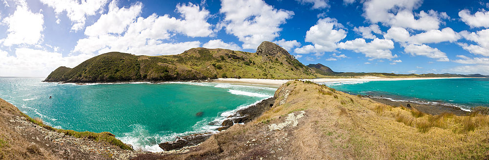
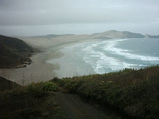
Te-Oneroa-a-Tōhē / Ninety Mile Beach is on the western coast of the far north of the North Island of New Zealand. The beach is actually 88 kilometres long. Its southern end is close to the headland of Tauroa Point, to the west of Ahipara Bay, near Kaitaia. From there it sweeps briefly northeast before running northwest along the Aupōuri Peninsula for the majority of its length. It ends at Tiriparepa / Scott Point, 5 kilometres (3 mi) south of Cape Maria van Diemen and about 10 kilometres (6 mi) south of Cape Reinga / Te Rerenga Wairua.

Kaitaia is a town in the Far North District of New Zealand, at the base of the Aupōuri Peninsula, about 160 km northwest of Whangārei. It is the last major settlement on State Highway 1. Ahipara Bay, the southern end of Te Oneroa-a-Tōhē / Ninety Mile Beach, is 5 kilometres (3.1 mi) west.

Ngāti Whātua is a Māori iwi (tribe) of the lower Northland Peninsula of New Zealand's North Island. It comprises a confederation of four hapū (subtribes) interconnected both by ancestry and by association over time: Te Uri-o-Hau, Te Roroa, Te Taoū, Ngāti Whātua o Kaipara and Ngāti Whātua-o-Ōrākei. The five hapū can act together or separately as independent tribes.
Te Aupōuri is the second northernmost Māori iwi, located north of Kaitaia, Northland, New Zealand, a region known as the Te Hiku o te Ika. The iwi is one of the six Muriwhenua iwi of the far north of the North Island.

Matiu Waitai Rata was a Māori politician who was a member of the New Zealand Parliament for the Labour Party from 1963 to 1980, and a cabinet minister from 1972 to 1975. In 1979 he resigned from the Labour Party and formed the Mana Motuhake Party.

William Gilbert Puckey, born in Penryn, England, was a missionary in New Zealand. He accompanied his parents to New Zealand at the age of 14. He became widely regarded as one of the best interpreters of Māori in the fledgling mission. He was able to form relationships of trust with many influential Māori from a young age, and in particular, with Nōpera Panakareao, of Te Rarawa iwi at Kaitaia.

Ahipara is a town and locality in Northland, New Zealand at the southern end of Ninety Mile Beach, with the Tauroa Peninsula to the west and Herekino Forest to the east. Ahipara Bay is to the north west. Kaitaia is 14 km to the north east, and Pukepoto is between the two.

Herekino is a locality in Northland, New Zealand. It lies 26 km south west of Kaitaia. The Herekino Harbour, also called the Herekino River, is an estuary and inlet from the Tasman Sea to the west. The Herekino Forest, which contains a stand of large kauri, is to the north, and the Tauroa Peninsula lies to the north west.
Ngataki is a community on the Aupouri Peninsula in Northland, New Zealand. State Highway 1 runs through the area. To the east is Rarawa Beach, a mile-long strip of clean silver sand, gently shelving and backed by sand dunes. To the north-east is the Great Exhibition Bay and Rarawa Bay and to the south-west is the long Ninety Mile Beach coastline.

Ngāi Takoto is a Māori iwi from Northland, New Zealand. The iwi is one of the six Muriwhenua iwi of the far north of the North Island. Ngāi Takoto trace their whakapapa (ancestry) back to Tuwhakatere, and trace their arrival in New Zealand to the Kurahaupo waka (canoe). The rohe of the iwi is focused on the upper North Island and extends to Kermadec Islands, Three Kings Island, Cape Reinga, Pao Island, Ninety Mile Beach, Waimimiha River, Ohaku hills, Whangatane River, Rangaunu Harbour and North Cape.

Ngāti Kurī is a Māori iwi from Northland, New Zealand. The iwi is one of the five Muriwhenua iwi of the far north of the North Island. Ngāti Kurī trace their whakapapa (ancestry) back to Pōhurihanga, the captain of the waka (canoe) Kurahaupō. Kurī, in Māori, means "dog". The rohe of the iwi is focused on the most northern tip of the North Island and includes the Kermadec Islands, Manawatāwhi / Three Kings Islands, Cape Reinga / Te Rerenga Wairua, Ninety Mile Beach, Parengarenga Harbour, Te Kao and Houhora.
Rongowhakaata is a Māori iwi of the Gisborne region of New Zealand.
Te Rarawa is a Māori iwi of Northland, New Zealand. The iwi is one of six Muriwhenua iwi of the far north of the North Island.
Anahera Herbert-Graves was the Chief Executive Officer of Te Runanga-a-Iwi o Ngāti Kahu from July 2006 to December 2021, the tribal parliament of the New Zealand Māori tribe Ngāti Kahu.
Muriwhenua are a group of northern Māori iwi, based in Te Hiku o te Ika, the northernmost part of New Zealand's North Island. It consists of six iwi, Ngāti Kurī, Ngāi Takoto, Te Pātū, Ngāti Kahu, Te Aupōuri and Te Rarawa, with a combined population of about 34,000 people. The spiritually significant Hokianga Harbour, located just to the south of the Maungataniwha Range, is of special significance to the Muriwhenua people.

In Re the Ninety-Mile Beach was a decision of the Court of Appeal of New Zealand holding that Maori could not hold title to the foreshore because of the effect of section 147 of the Harbours Act 1878 ; and because investigation of title to land adjacent to the sea by the Māori Land Court had extinguished rights to land below the high water mark. The decision was overturned in 2003 by Ngati Apa v Attorney-General.
Te Tai Tokerau Māori are a group of Māori iwi (tribes) based on the Northland Peninsula of New Zealand's North Island. It includes the far northern Muriwhenua iwi (tribes) of Te Aupōuri, Ngāti Kahu, Ngāti Kurī, Te Pātū, Te Rarawa and Ngāi Takoto. It also includes Ngāpuhi and the affiliated iwi of Ngāti Hine. Elsewhere in the region, it includes Whaingaroa, Ngāti Wai and Ngāti Whātua.

Saana Romana Murray, also known as Hana Waitai Murray, was a Māori master weaver, poet and writer in New Zealand, who was affiliated with Ngāti Kurī at Aupouri. She was the only claimant on the Wai 262 claim still alive when the report was delivered.