
The Vaal Dam in South Africa was constructed in 1938 and lies 77 km south of OR Tambo International Airport. The lake behind the dam wall has a surface area of about 320 square kilometres (120 sq mi) and is 47 meters deep. The Vaal Dam lies on the Vaal River, which is one of South Africa's strongest-flowing rivers. Other rivers flowing into the dam are the Wilge River, Klip River, Molspruit and Grootspruit. It has over 800 kilometres (500 mi) of shoreline and is South Africa's second biggest dam by area and the fourth largest by volume.

Gariep Dam located in South Africa, near the town of Norvalspont, bordering the Free State and Eastern Cape provinces. Its primary purpose is for irrigation, domestic and industrial use as well as for power generation.

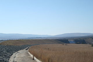
The Vanderkloof Dam is situated approximately 130 km (81 mi) downstream from Gariep Dam and is fed by the Orange River, South Africa's largest river. Vanderkloof Dam is the second-largest dam in South Africa, having the highest dam wall in the country at 108 metres (354 ft). The dam was commissioned in 1977; it has a capacity of 3,187.557 million cubic metres (2,584,195 acre⋅ft) and a surface area of 133.43 square kilometres (51.52 sq mi) when full. Other rivers flowing into this dam are the Berg River, two unnamed streams coming in from the direction of Reebokrand, the Knapsak River, Paaiskloofspruit, Seekoei River, Kattegatspruit and the Hondeblaf River, in a clockwise direction.
The Albasini Dam is a dam located just outside the town of Louis Trichardt, Limpopo Province, South Africa. The dam has a capacity of 25,200,000 cubic metres (890,000,000 cu ft), and a surface area of 3.572 square kilometres (1.379 sq mi). The wall is 34 metres (112 ft) high.

Albert Falls Dam is a dam in the Umgeni River, just outside Pietermaritzburg, KwaZulu-Natal, South Africa. It was established in 1976. It has a gross capacity of 290.1 million cubic meters and a surface area of 23.521 square kilometres (9.082 sq mi), the dam wall is 33 metres (108 ft) high.
The Allemanskraal Dam is a dam in the Free State province of South Africa, on the Sand River. It was established in 1960. The reservoir has a gross capacity of 174,500 cubic metres (6,160,000 cu ft), and a surface area of 26.481 square kilometres (10.224 sq mi), the dam wall is 38 metres (125 ft) high.
Armenia Dam is a dam in the Leeu River, near Hobhouse, Free State province, South Africa. It was established in 1954. It has a capacity of 13,000 cubic metres (460,000 cu ft), and a surface area of 3.933 square kilometres (1.519 sq mi), the wall is 22 metres (72 ft) high.
Beervlei Dam is a dam in the Groot River, Eastern Cape, South Africa. It was established in 1957, has a capacity of 85,800,000 cubic metres (3.03×10⁹ cu ft), and a surface area of 23.145 square kilometres (8.936 sq mi), and the dam wall is 31 m high. The main purpose of the dam is to provide flood absorption. The Karoo sediments in the area contain a lot of salts and it has been found that lengthy storage of water results in high water salinity. Any flood water is used as quickly as possible by the downstream irrigators and the reservoir is kept empty for extended periods.
Darlington Dam, also referred to as Lake Mentz. is a gravity type dam situated in the Sundays River, near Kirkwood, in Eastern Cape, South Africa. It was established in 1922 and was renovated in 1952. The dam has a capacity of 187,000,000 cubic metres (6.6×10⁹ cu ft), with a 35.3 metres (116 ft)-high wall. Its primary purpose is for irrigation, industrial and domestic use.
Goedertrouw Dam is an earth-filled dam in South Africa. The Dam was constructed on the Mhlathuze River, near Eshowe, KwaZulu-Natal, in 1980. It currently has a capacity of 301 million m3 and is principally for provision of water to the industrial complex at Richards Bay. It serves also as reservoir for irrigation and domestic use. The hazard potential of the dam has been ranked high (3).
Kwena Dam is a combined gravity & arch type dam located on the Crocodile River, near Lydenburg, Mpumalanga province, South Africa. It was established in 1984 and it serves mainly for irrigation purposes. The hazard potential of the dam has been ranked high (3).
Middle Letaba Dam is an earth-fill type dam located on the Middle Letaba River, 40 km east of Elim and 40 km west of Giyani, Limpopo, South Africa. The source of the Middle Letaba river rises high in the tropical mountains of Magoebaskloof near Tzaneen, where rainfall is abundant during the summer months. The river passes numerous villages and its flow becomes quite strong when it reaches the village of Magoro.

Nzhelele Dam is an arch type dam located on the Nzhelele River in Limpopo Province, South Africa. It has a capacity of 55.3 million m3. It was established in 1948. The main purpose of the dam is to serve for irrigation and its hazard potentials has been ranked high (3).
Welbedacht Dam is a concrete-gravity type dam situated in South Africa, and was established in 1973. Bloemfontein is the sixth-largest city in South Africa, with a population around 300 000. It is situated in the Modder River catchment, which has insufficient water resources to meet the growing water requirements. The water supply to Bloemfontein is, therefore, augmented from the adjacent Caledon River by means of the Caledon - Modder River Government Water Scheme (CMRGWS).

Wemmershoek Dam is an earth-fill type dam located on the Wemmershoek River near Franschhoek and Paarl in South Africa. The dam was established in 1957 with a capacity of 58 644 000 m3 behind a 55 m high wall. The dam serves mainly for municipal and industrial use as part of the Western Cape Water Supply System which supplies the city of Cape Town and surrounding areas. Its hazard potential has been ranked high (3).
Zaaihoek Dam is a gravity type dam located on the Slang River in Mpumalanga Province of South Africa. The dam was established in 1988 with a capacity of 185 000 000 m3. The dam serves primarily for municipal and industrial water supply purposes. Its hazard potential has been ranked high (3).
Bongolo Dam, is located on the Komani River, near Queenstown, Eastern Cape, South Africa. The dam has a capacity of 7,015,000 cubic metres (247,700,000 cu ft). The Bongolo Dam, about 5 kilometres (3.1 mi) from town on the Dordrecht road, is one of Queenstown's main sources of water, its main purpose is for industrial and municipal usage. The wall was begun in 1905 and was for years the largest concrete dam wall in South Africa. Incidentally the origin of the name Bongola has caused some controversy, but it is believed by some to have been derived from the Xhosa language word mbongolo meaning donkey, as these animals were extensively used in the construction of the dam.
Stompdrift Dam is a combined multi-arch and gravity type dam located on the Olifants River near De Rust, Western Cape, South Africa.
The Rust de Winter Dam is a dam located on the Elands River, Limpopo, South Africa.


